Ashuanipi

Last updated
Territory of Ashuanipi
French: Territoire d'Ashuanipi
Territory of Quebec
1899–1927
Carte Ashuanipi.svg
  Ashuanipi
  Territory currently claimed by Quebec
History 
 Established
1899
 Disestablished
1927
Preceded by
Succeeded by
Blank.png District of Ungava
Dominion of Newfoundland Flag of the Dominion of Newfoundland.svg
Today part of

The Territory of Ashuanipi (French : Territoire d'Ashuanipi) was a formerly disputed area and territory of Quebec that was claimed by Quebec and the Dominion of Newfoundland from 1899 and 1927.

Contents

Ashuanipi was first devised under the territorial claims of the Quebec Boundary Extension Act, 1898 , and then subdivided under the 1899 An Act respecting the territories of Abittibi, Mistassini and Ashuanipi. The territory would be effectively annulled after a 1927 ruling by the Judicial Committee of the Privy Council defining the border between Newfoundland and Canada, but Quebec continues to recognize the region as a territory of Quebec in the Territorial Division Act.

Description

A map of Quebec's Cote-Nord from 1900 with Ashuanipi highlighted Cote-Nord - Carte de la province de Quebec 1900 (cropped).jpg
A map of Quebec's Côte-Nord from 1900 with Ashuanipi highlighted

The territory of Ashuanipi was defined under the terms of An Act respecting the territories of Abittibi, Mistassini and Ashuanipi [1] (French : Loi concernant les territoires d'Abittibi, de Mistassini et d'Ashuanipi) of 1899. Article 2.3 of the act read: "The territory of Ashuanipi is bounded to the north, to the east and to the west by the limits of the province; and to the south and southwest by the county of Saguenay". [2] The Revised Statutes of the Province of Quebec (1909) recognized the same description of the territory. [3] The Territorial Division Act's description remains largely the same, but alters the south and southwest portion's boundaries by the "electoral districts of Duplessis and Saguenay". [4]

The territory, as defined by the provisions of the former act, directly included the river basins of the Ashuanipi River, Hamilton River, and Esquimaux River. It additionally included "all other parts of territory watered by water-courses flowing directly towards the Atlantic". [3]

History

When Canada purchased the territory of Rupert's Land from the Hudson's Bay Company in 1870, the potential for territorial expansion northwards became available to the Quebec government. During a session held on April 8, 1885, the Legislative Assembly of Quebec devised a special committee with regards to the potential expansion of the border into the north. The borders that were devised by the committee were adopted by both the Parliament of Quebec and the Parliament of Canada in 1898 as the Boundaries Extension Acts of 1898 . In the provisions of An Act respecting the territories of Abittibi, Mistassini and Ashuanipi of 1899, the newly annexed northern territory was divided into three regions. [2] The act decreed that the lands of Abitibi and Mistassini would be annexed alongside it. [5] [4] The area that was claimed remained poorly defined at its eastern frontier, running alongside the Dominion of Newfoundland's claim, whose border was also poorly defined at the time. [6] During its existence as a territory of Quebec, for judicial and registration purposes, the territory of Ashuanipi formed a part of the historical county of Saguenay. [3]

In 1912, a further extension was granted for Quebec under the provisions of the Quebec Boundaries Extension Act, 1912 , allowing Quebec's northern border to include that of the remainder of the District of Ungava. This revision continued to be ambiguous with regards to the definition of the territory, continuing to refer to the area on the eastern reaches as the land "over which the island of Newfoundland has lawful jurisdiction". [7]

The territory ceased to exist in 1927, following a ruling by the Judicial Committee of the Privy Council, which ruled that the 52nd parallel north would serve as an effective border between Newfoundland and Canada. [8] [9] As much of Ashuanipi lay north the parallel, the territorial claim was effectively annulled. Quebec continues to assert a claim over the portions between the southern portions of Ashuanipi and the 52nd parallel. [8]

Contemporary Quebec

Ashuanipi continues to be recognized as a territory within the provisions of the Territorial Division Act. The act's provisions state that it is under the registration division of Sept-Îles, alongside the provincial riding of Duplessis, and the territory of New Québec. [4]

See also

Related Research Articles

<span class="mw-page-title-main">Labrador</span> Mainland portion of Newfoundland and Labrador

Labrador is a geographic and cultural region within the Canadian provinces of Newfoundland and Labrador and Quebec. It is the primarily continental portion of the province and constitutes 71% of the province's area but is home to only 6% of its population. It is separated from the island of Newfoundland by the Strait of Belle Isle. It is the largest and northernmost geographical region in the four Atlantic provinces.

<span class="mw-page-title-main">Alma, Quebec</span> Town in Quebec, Canada

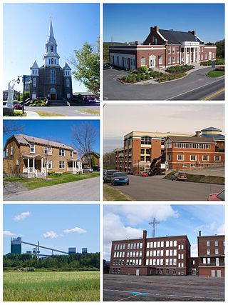
Alma is a town in Saguenay–Lac-Saint-Jean, in the Canadian province of Quebec.

<span class="mw-page-title-main">Saguenay–Lac-Saint-Jean</span> Région in Quebec, Canada

Saguenay–Lac-Saint-Jean is a region in Quebec, Canada on the Labrador Peninsula. It contains the Saguenay Fjord, the estuary of the Saguenay River, stretching through much of the region. It is also known as Sagamie in French, from the first part of "Saguenay" and the last part of "Piekouagami", the Innu name for Lac Saint-Jean, with the final "e" added to follow the model of other existing region names such as Mauricie, Témiscamie, Jamésie, and Matawinie. With a land area of 98,712.71 km2 (38,113.19 sq mi), Saguenay–Lac-Saint-Jean is the third-largest Quebec region after Nord-du-Québec and Côte-Nord.

<span class="mw-page-title-main">Legislative Council of Quebec</span> Former upper house of the Quebec Legislature

The Legislative Council of Quebec was the unelected upper house of the bicameral legislature in the Canadian province of Quebec from 1867 to 1968. The Legislative Assembly was the elected lower house.

<span class="mw-page-title-main">Census geographic units of Canada</span> Term used in Canada

The census geographic units of Canada are the census subdivisions defined and used by Canada's federal government statistics bureau Statistics Canada to conduct the country's quinquennial census. These areas exist solely for the purposes of statistical analysis and presentation; they have no government of their own. They exist on four levels: the top-level (first-level) divisions are Canada's provinces and territories; these are divided into second-level census divisions, which in turn are divided into third-level census subdivisions and fourth-level dissemination areas.

<span class="mw-page-title-main">Lac-Saint-Jean-Est Regional County Municipality</span> Regional county municipality in Quebec, Canada

Lac-Saint-Jean-Est is a regional county municipality in the Saguenay–Lac-Saint-Jean region of Quebec, Canada. The seat is Alma. In 2016, 99.3% reported that they spoke French most often at home, according to the census.

<span class="mw-page-title-main">Le Fjord-du-Saguenay Regional County Municipality</span> Regional county municipality in Quebec, Canada

Le Fjord-du-Saguenay is a regional county municipality in the Saguenay-Lac-Saint-Jean region of Quebec, Canada. Its seat is Saint-Honoré, which is also its most populous municipality.

<span class="mw-page-title-main">Maria-Chapdelaine Regional County Municipality</span> Regional county municipality in Quebec, Canada

Maria-Chapdelaine is a regional county municipality in the Saguenay–Lac-Saint-Jean region of Quebec, Canada. Its seat is in Dolbeau-Mistassini.

<span class="mw-page-title-main">Regional county municipality</span> County-like political entities in Quebec, Canada

The term regional county municipality or RCM is used in Quebec, Canada to refer to one of 87 county-like political entities. In some older English translations they were called county regional municipality.

<span class="mw-page-title-main">Roberval, Quebec</span> City in Quebec, Canada

Roberval is a city on the south-western shore of Lac Saint-Jean in the Le Domaine-du-Roy Regional County Municipality of Quebec, Canada. With a population of 9,840 in the Canada 2021 Census, it is the fourth largest city on this lake after Alma, Dolbeau-Mistassini and Saint-Félicien. It is the seat of the Domaine-du-Roy RCM and the main service centre for the region with a hospital and some government services. It is also the seat of the judicial district of Roberval.

<span class="mw-page-title-main">Urban agglomeration of Montreal</span> Urban agglomeration in Quebec, Canada

The urban agglomeration of Montreal is an urban agglomeration in Quebec, Canada. Coextensive with the administrative region of Montréal, it is a territory equivalent to a regional county municipality (TE) and a census division (CD), for both of which its geographical code is 66. Prior to the merger of the municipalities in Region 06 in 2002, the administrative region was co-extensive with the Montreal Urban Community.

<i>Quebec Boundaries Extension Act, 1912</i>

The Quebec Boundaries Extension Act, 1912 was passed by the Parliament of Canada on April 1, 1912. It expanded the territory of the Province of Quebec, extending the northern boundary to its present location. The act transferred to the province all of the Northwest Territories' former District of Ungava except offshore islands. This is a vast area bounded by the Eastmain River, the Labrador coast, and Hudson and Ungava Bays. It was first claimed by England in 1670 as Rupert's Land by royal decree, becoming part of Canada after Confederation. The indigenous people of the region are Cree, Montagnais, Naskapi, and Inuit.

The following is a list of the types of local and supralocal territorial units in Quebec, Canada, including those used solely for statistical purposes, as defined by the Ministry of Municipal Affairs, Regions and Land Occupancy and compiled by the Institut de la statistique du Québec.

<span class="mw-page-title-main">Territorial evolution of Canada</span>

The history of post-confederation Canada began on July 1, 1867, when the British North American colonies of Canada, New Brunswick, and Nova Scotia were united to form a single Dominion within the British Empire. Upon Confederation, the United Province of Canada was immediately split into the provinces of Ontario and Quebec. The colonies of Prince Edward Island and British Columbia joined shortly after, and Canada acquired the vast expanse of the continent controlled by the Hudson's Bay Company, which was eventually divided into new territories and provinces. Canada evolved into a fully sovereign state by 1982.

<span class="mw-page-title-main">Administrative divisions of Quebec</span> Overview of political subdivisions of Quebec

The Province of Quebec is divided into entities that deliver local government, along with other types of functional divisions.

<span class="mw-page-title-main">Urban agglomeration of Longueuil</span> Urban agglomeration in Quebec, Canada

The urban agglomeration of Longueuil was created on January 1, 2006 as a result of the de-amalgamation process brought upon by the Charest government. It encompasses all the boroughs that were merged into the previous city of Longueuil and still retains the same area as that mega-city.

<span class="mw-page-title-main">Mont-Valin, Quebec</span> Unorganized territory in Quebec, Canada

Mont-Valin is an unorganized territory in the Canadian province of Quebec. It makes up over 87% of Le Fjord-du-Saguenay Regional County Municipality and is the largest subdivision of the Saguenay–Lac-Saint-Jean region. The territory, named after Mount Valin, had a population of 10 as of the Canada 2021 Census, and covered a land area of 33,540.39 km2.

The Communauté maritime des Îles-de-la-Madeleine, commonly designated as the Agglomeration of Les Îles-de-la-Madeleine, is located on the islands of the Magdalen Islands archipelago, that bathes in the waters of the Gulf of St. Lawrence, 250 km from Gaspé, 120 km from Prince Edward Island, 90 km from Cape Breton Island and 150 km from Newfoundland. the municipality of Les Îles-de-la-Madeleine

<span class="mw-page-title-main">Newfoundland and Labrador–Quebec border</span> Border between two Canadian provinces

The border between the province of Newfoundland and Labrador and the province of Quebec is the longest interprovincial border in Canada. It stretches for more than 3,500 kilometres (2,200 mi) on land, and, according to both provincial governments, also contains a maritime part. Starting from the north, the border follows the Laurentian Divide on the Labrador Peninsula for the majority of the border's length, then follows the divide between the Côte-Nord-Gaspé and Newfoundland-Labrador drainage basins as far as Brûlé Lake, after which it goes along the Romaine River downstream to the 52nd parallel, which it follows east to its southeastern terminus at Blanc-Sablon.

References

  1. Gazette Officielle du Québec - QUEBEC OFFICIAL GAZETTE (in French) (XXXI ed.). 4 March 1899. Retrieved 11 May 2022.
  2. 1 2 "Loi concernant les territoires d'Abittibi, de Mistassini et d'Ashuanipi". Territoire d'Abitibi, etc. National Assembly of Quebec - Assemblée nationale. 1899. p. 31. Retrieved 11 May 2022.
  3. 1 2 3 The revised statutes of the province of Quebec, 1909. 1909. pp. 101–102. Retrieved 11 May 2022.
  4. 1 2 3 "chapter D-11 Territorial Division Act DIVISION I DIVISION OF QUÉBEC FOR CERTAIN PURPOSES". Légis Québec. Les Publications du Québec Ministère du Travail, de l'Emploi et de la Solidarité sociale. Retrieved 11 May 2022.
  5. Frenette, Jacques (10 April 2014). "Les lois de l'extension des frontières du Québec de 1898 et de 1912, la Convention de la Baie James et du Nord québécois et la Première Nation Abitibiwinni" (PDF). Recherches amérindiennes au Québec. 43 (1): 87–104. doi:10.7202/1024476ar . Retrieved 11 May 2022.
  6. "L'Atlas du Canada. Évolution territoriale, 1898". Natural Resources Canada (in French). 2009-03-18. Archived from the original on 2011-09-18. Retrieved 2022-05-11.
  7. British North America Acts 1867–1907 (PDF). Ottawa: C. H. Parmelee. 1913. pp. 235–236.
  8. 1 2 Jacobs, Frank (2012-07-10). "Oh, (No) Canada!". Opinionator: Borderlines. The New York Times. Archived from the original on 2019-10-01. Retrieved 2012-09-23.
  9. Machabée, Daniel (19 March 2022). "Le Labrador". Journal des Citoyens (in French). Retrieved 11 May 2022.