Related Research Articles

Freetown is a town in Bristol County, Massachusetts, United States. The population was 9,206 at the 2020 census.

Green-Wood Cemetery is a 478-acre (193 ha) cemetery in the western portion of Brooklyn, New York City. The cemetery is located between South Slope/Greenwood Heights, Park Slope, Windsor Terrace, Borough Park, Kensington, and Sunset Park, and lies several blocks southwest of Prospect Park. Its boundaries include, among other streets, 20th Street to the northeast, Fifth Avenue to the northwest, 36th and 37th Streets to the southwest, Fort Hamilton Parkway to the south, and McDonald Avenue to the east.

The Taunton River, historically also called the Taunton Great River, is a river in southeastern Massachusetts in the United States. It arises from the confluence of the Town River and Matfield River, in the town of Bridgewater. From there it meanders through the towns of Halifax, Middleborough and Raynham, through the city of Taunton for which it is named, the towns of Berkley, Dighton, Somerset, and the Assonet section of Freetown, to Fall River where it joins Mount Hope Bay, an arm of Narragansett Bay.
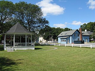
Assonet is one of two villages in the town of Freetown, Massachusetts in Bristol County, Massachusetts, United States. An original part of the town, Assonet was settled in 1659 along with the city of Fall River, then a part of Freetown. It rests on the banks of the Assonet River. As of the 2000 census, the village had a total population of 4,084; up from 3,614 in 1990. As of the 2014 census the village had a total estimated population of 9,093.

The Assonet River is located in Bristol County, Massachusetts. It flows 7.4 miles (11.9 km) in a westerly direction through Freetown and joins the Taunton River near Assonet Neck in Berkley, Massachusetts.
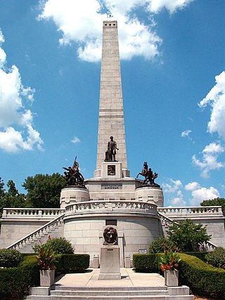
The Lincoln Tomb is the final resting place of Abraham Lincoln, the 16th President of the United States; his wife Mary Todd Lincoln; and three of their four sons: Edward, William, and Thomas. It is located in Oak Ridge Cemetery in Springfield, Illinois. It is constructed of granite and has a large, single-story rectangular base surmounted by an obelisk, with a semicircular receiving room entranceway on one end and a semicircular crypt or burial-room opposite.

The Mount Hope Bay raids were a series of military raids conducted by British troops during the American Revolutionary War against communities on the shores of Mount Hope Bay on May 25 and 31, 1778. The towns of Bristol and Warren, Rhode Island were significantly damaged, and Freetown, Massachusetts was also attacked, although its militia resisted British attacks more successfully. The British destroyed military defenses in the area, including supplies that had been cached by the Continental Army in anticipation of an assault on British-occupied Newport, Rhode Island. Homes as well as municipal and religious buildings were also destroyed in the raids.

Forest Hills Cemetery is a historic 275-acre (111.3 ha) rural cemetery, greenspace, arboretum and sculpture garden located in the Forest Hills section of the Jamaica Plain neighborhood of Boston, Massachusetts. The cemetery was established in 1848 as a public municipal cemetery of the town of Roxbury, but was privatized when Roxbury was annexed to Boston in 1868.
Conspiracy Island is a privately owned tidal island situated in the Assonet River off Berkley, Massachusetts.

The Freetown-Fall River State Forest is a publicly owned forest covering more than 5,000 acres (2,000 ha) in the city of Fall River and the towns of Freetown and Lakeville in the state of Massachusetts. The forest lies mostly in the center of the town of Freetown dividing Assonet, East Freetown, and Fall River's northernmost boundary. The forest land includes Profile Rock, a granite outcropping which local Native Americans believe to be the image of Chief Massasoit, and a 227-acre (92 ha) Wampanoag reservation. The forest is owned by the Commonwealth of Massachusetts and operated by the Department of Conservation and Recreation with headquarters in Assonet.

The West Parish Burying Ground, also known as the River Street Burying Ground or River Street Cemetery, is a cemetery located at River and Cherry streets in West Newton, Massachusetts, and is listed on the National Register of Historic Places. Established in 1777, the cemetery is owned and maintained by the City of Newton; the Second Church in Newton, its original owner, was known as the West Parish.
East Parish Burying Ground, also known as Centre Street Burying Ground or Centre Street Cemetery, is an historic cemetery located at Centre and Cotton streets in the village of Newton Corner in the city of Newton, Massachusetts. On December 23, 1983, it was listed on the National Register of Historic Places. It has been called the "most important, the most evocative and also the most fragile historic site in the city."

John Milton Deane, was an American Civil War Medal of Honor recipient and a major in the United States Army.
The Rumney Marsh Burying Ground is a historic cemetery on Butler Street between Elm and Bixby Streets in Revere, Massachusetts. It was added to the National Register of Historic Places in 2004. It was the first burying ground of an area that now encompasses Revere as well as neighboring Chelsea and Winthrop.

Pittsfield Cemetery is a historic cemetery at 203 Wahconah Street in Pittsfield, Massachusetts. Established in 1850, it is good example of a rural cemetery, and is the resting ground of many prominent Pittsfield residents, with a number of architecturally significant elements. It also houses a number of Pittsfield's earliest burials, which were relocated here from a cemetery near the city center. The cemetery was listed on the National Register of Historic Places in 2007.
Abner Jones, also known as Elder Abner Jones, was a minister and early church reformer in the United States.

Ebenezer Weaver Peirce, was a brigadier general in the Massachusetts militia, serving as 90–day volunteers in the Union Army in the opening months of the American Civil War, and a colonel of the 29th Massachusetts Volunteer Infantry Regiment of the Union Army between December 1861 and July 1864. He later became a farmer, real estate speculator, historian and genealogist.

Walnut Hills Cemetery is a historic cemetery on Grove Street and Allandale Road in Brookline, Massachusetts. It encompasses 45.26 acres (18.32 ha), with mature trees and puddingstone outcrops, and was laid out in 1875 in the then-fashionable rural cemetery style. Many past prominent citizens of the town, including architect H.H. Richardson, are buried here. The cemetery was listed on the National Register of Historic Places in 1985.
The Old Village Cemetery is an historic cemetery in Dedham, Massachusetts.

Brookdale Cemetery is an historic cemetery in Dedham, Massachusetts. More than 28,000 people are buried there. Mother Brook runs behind it.
References
- ↑ Deane, Maj. John M. A History of the Town of Freetown, Massachusetts: Record and Tradition. Assonet: Assonet Village Improvement Society, 1902.