Aston Valley Barrow Cemetery

Last updated

Aston Valley Barrow Cemetery
Wiltshire UK location map.svg
Archaeological site icon (red).svg
Shown within Wiltshire
Alternative nameAshton Valley Barrow Cemetery
Location Wiltshire
RegionSouthern England
Coordinates 51°11′07″N2°01′48″W / 51.1853°N 2.0301°W / 51.1853; -2.0301
TypeBarrow cemetery
History
MaterialChalk
PeriodsBronze Age
Site notes
Archaeologists Sir Richard Colt Hoare,
W.F.Cunnington,
L.Grinsell,
Rev.E.H.Steele
A pencil sketch showing, in the upper plate, the original arrangement of the barrows, from The Ancient History of Wiltshire, by Sir Richard Colt-Hoare, 1810 Tumuli at Ashton Valley and earthworks at Elder Valley.jpg
A pencil sketch showing, in the upper plate, the original arrangement of the barrows, from The Ancient History of Wiltshire, by Sir Richard Colt-Hoare, 1810
A pencil sketch showing some of the artefacts found within the barrows at Ashton Valley, from The Ancient History of Wiltshire, by Sir Richard Colt-Hoare, 1810 Artefacts from Ashton Valley.jpg
A pencil sketch showing some of the artefacts found within the barrows at Ashton Valley, from The Ancient History of Wiltshire, by Sir Richard Colt-Hoare, 1810

The Aston Valley Barrow Cemetery, or Ashton Valley Barrow Cemetery, is a group of Bronze Age bowl barrow and bell barrow tumuli on the south facing edge of Codford Down on the west side of the valley of the Chitterne Brook, within the civil parish of Codford, in Wiltshire, England. There were originally ten bowl barrows and a single bell barrow, but some of these have now been ploughed out: only the bell barrow and five bowl barrows survive. [1] The site is a scheduled monument. [2]

Contents

Context

The site lies in close proximity to Codford Circle, an Iron Age hillfort or enclosure some 2 km (1.2 mi) to the southeast, and Knook Castle, an Iron Age hillfort a similar distance to the northwest.

Archaeology

Excavations at the barrows have revealed many Bronze Age and some possible Saxon urned cremations and other interments. The barrows were originally excavated by W.F. Cunnington in 1801, and recorded by Sir R. Colt-Hoare, with later excavations by the Reverend E.H. Steele in 1957; and with further correlations by Leslie Grinsell, also in 1957. Some burials and items were left in place by Cunnington, but others are now preserved at the Wiltshire Museum in Devizes. [1]

The excavations by Colt-Hoare and Cunnington in the 1800s revealed most of the finds and interments. However, as the three-age system had not yet been introduced, and they were unable to properly date their finds, they were at a disadvantage when trying to interpret them.

The following table includes details for the eleven barrows and associated finds:

A list of the Barrows at Ashton Valley
Name/referenceLocationTypeSizeNMR numberDescription and finds
Barrow A
Monument no.887655
grid reference ST97914268 Bowl barrow23.5 m (25.7 yd) wide by 2.2 m (7.2 ft) highST 94 SE 54The largest barrow in the cemetery. Finds included cremated remains of a primary burial within a large urn and other secondary remains including nine smaller cremation urns, sherds and burnt bones. [3]
Barrow B
Monument no.887681
grid reference ST97914274 Bowl barrow20 m (22 yd) wide by 1.0 m (3.3 ft) highST 94 SE 55Contained a probable Bronze Age cremation. [4]
Barrow C
Monument no.887692
grid reference ST97914277 Bowl barrow15.5 m (17.0 yd) wide by 0.3 m (0.98 ft) highST 94 SE 56No finds. [5]
Barrow D
Monument no.887703
grid reference ST97894280 Bell barrow22.5 m (24.6 yd) wide by 2.8 m (9.2 ft) highST 94 SE 57Surrounding quarry ditch 5 m (5.5 yd) wide and 0.5 m (0.55 yd) deep. Contained a cremation beneath an inverted Bronze Age urn along with a perforated dolerite battle-axe or hammer. [6]
Barrow E
Monument no.887709
grid reference ST97874277 Bowl barrow21 m (23 yd) wide by 0.4 m (1.3 ft) highST 94 SE 58Contained a primary cremation along with a granodiorite battle axe and a bone point. [7]
Barrow F
Monument no.887713
grid reference ST98044280 Bowl barrow30 m (33 yd) wide by 1 m (3.3 ft) highST 94 SE 59,
ST 94 SE 60
Contained a primary cremation and a later Saxon inhumation along with a fir-wood bucket bound with bronze, and a possible sword or spearhead. [8]
Barrow G
Monument no.887718
grid reference ST97954269 Bowl barrownow ploughed outST 94 SE 61Contained a circular shaft with a nearby possible cremation, and other secondary cremations with urn fragments. [9]
Barrow H
Monument no.887751
grid reference ST97904290 Bowl barrownow ploughed outST 94 SE 62Contained a human burial in a wooden coffin. [10]
Barrow J
Monument no.887757
grid reference ST97844280 Bowl barrownow ploughed outST 94 SE 63Contained a cremation within a crushed urn. [11]
Barrow K
Monument no.888063
grid reference ST97864280 Bowl barrownow ploughed outST 94 SE 64Contained a cremation (possibly two) within urns. [12]
Barrow L
Monument no.888065
grid reference ST97884279 Bowl barrownow ploughed outST 94 SE 65Contained a cremation within a crushed urn. [12]

Related Research Articles

<span class="mw-page-title-main">Badbury Rings</span> Iron Age hill fort in east Dorset, England

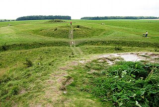
Badbury Rings is an Iron Age hill fort and Scheduled Monument in east Dorset, England. It was in the territory of the Durotriges. In the Roman era a temple was located immediately west of the fort, and there was a Romano-British town known as Vindocladia a short distance to the south-west.

<span class="mw-page-title-main">Codford</span> Civil parish in Wiltshire, England

Codford is a civil parish south of Salisbury Plain in the Wylye Valley in Wiltshire, England. Its settlements are the adjacent villages of Codford St Peter and Codford St Mary, which lie some 7 miles (11 km) southeast of Warminster.

<span class="mw-page-title-main">Upton Lovell</span> Human settlement in England

Upton Lovell is a village and civil parish in Wiltshire, England. It lies on the A36, in the Wylye valley about 5 miles (8.0 km) southeast of Warminster. The parish is on the left (northeast) bank of the river, and stretches for over two miles northeast onto Salisbury Plain.

<span class="mw-page-title-main">Cursus Barrows</span> Barrow cemetery in England

The Cursus Barrows is the name given to a Neolithic and Bronze Age round barrow cemetery lying mostly south of the western end of the Stonehenge Cursus, in Wiltshire, England. The cemetery contains around 18 barrows scattered along an east-to-west ridge, although some of the mounds are no longer visible. The Cursus Barrows can be seen just north of the route between the Stonehenge Visitor Centre and Stonehenge.

<span class="mw-page-title-main">Scratchbury Camp</span> Iron Age hillfort in Wiltshire, England

Scratchbury Camp is the site of an Iron Age univallate hillfort on Scratchbury Hill, overlooking the Wylye valley about 1 km northeast of the village of Norton Bavant in Wiltshire, England. The fort covers an area of 37 acres (15 ha) and occupies the summit of the hill on the edge of Salisbury Plain, with its four-sided shape largely following the natural contours of the hill.

Chisenbury Camp is the site of an Iron Age univallate hillfort in Broad Chalke parish in Wiltshire, England. The site comprises a small circular 5-acre enclosure that was levelled in 1931. The site was partially excavated in the 19th century and there were finds of ceramics, worked stone, worked animal bone and remains of human burial; some are held by the Wiltshire Museum at Devizes. It is a scheduled monument.

<span class="mw-page-title-main">Bratton Castle</span> Iron Age hillfort in Wiltshire, England

Bratton Castle is a bivallate Iron Age built hill fort on Bratton Down, at the western edge of the Salisbury Plain escarpment. The hill fort comprises two circuits of ditch and bank which together enclose a pentagonal area of 9.3 hectares.

<span class="mw-page-title-main">Fin Cop</span>

Fin Cop is a hill and an associated Iron Age hill fort in Monsal Dale, close to Ashford in the Water in Derbyshire, England.

<span class="mw-page-title-main">Knook Castle</span> Iron Age hillfort in Wiltshire, England

Knook Castle is the site of an Iron Age univallate hillfort on Knook Down, near the village of Knook in Wiltshire, England, but largely within the civil parish of Upton Lovell. It has also been interpreted as a defensive cattle enclosure associated with nearby Romano-British settlements. It is roughly rectangular in plan with a single entrance on the south/south-east side, but with a later break in the wall on the western side. The site is a scheduled monument.

William Hardy Lamplough was a British teacher and archaeologist based in Yorkshire.

<span class="mw-page-title-main">Scheduled monuments in Bath and North East Somerset</span>

Bath and North East Somerset is a unitary authority created on 1 April 1996, following the abolition of the County of Avon, which had existed since 1974. Part of the ceremonial county of Somerset, Bath and North East Somerset occupies an area of 220 square miles (570 km2), two-thirds of which is green belt. It stretches from the outskirts of Bristol, south into the Mendip Hills and east to the southern Cotswold Hills and Wiltshire border. The city of Bath is the principal settlement in the district, but BANES also covers Keynsham, Midsomer Norton, Radstock and the Chew Valley. The area has a population of 170,000, about half of whom live in Bath, making it 12 times more densely populated than the rest of the area.

<span class="mw-page-title-main">Scheduled monuments in Taunton Deane</span>

Taunton Deane was a local government district with borough status in Somerset, England. It merged with West Somerset to form Somerset West and Taunton on 1 April 2019. Its council was based in Taunton. The district was formed on 1 April 1974, under the Local Government Act 1972, by a merger of the Municipal Borough of Taunton, Wellington Urban District, Taunton Rural District, and Wellington Rural District. Taunton Deane was granted borough status in 1975, enabling the mayoralty of Taunton to be continued, when other districts did not have mayors. The district was given the name of an alternate form of the Taunton Deane Hundred.

<span class="mw-page-title-main">Scheduled monuments in Mendip</span>

Mendip is a local government district of Somerset in England. The Mendip district covers a largely rural area of 285 square miles (738 km2) ranging from the Mendip Hills through on to the Somerset Levels. It has a population of approximately 110,000. The administrative centre of the district is Shepton Mallet but the largest town is Frome.

<span class="mw-page-title-main">Hollingbury Castle</span>

Hollingbury Castle, also known as Hollingbury Camp and Hollingbury Hillfort, is an Iron Age hillfort on the northern edge of Brighton, in East Sussex, England. It is adjacent to Hollingbury Park Golf Course.

<span class="mw-page-title-main">Martin Down Enclosure</span>

The Martin Down Enclosure is an archaeological site on Martin Down, near the village of Martin, in Hampshire, England. It is near the boundaries with Dorset and Wiltshire.

West Somerset was a local government district in the English county of Somerset. It merged with Taunton Deane to form Somerset West and Taunton on 1 April 2019.

References

  1. 1 2 Historic England. "Ashton Valley (211332)". Research records (formerly PastScape). Retrieved 22 April 2012.
  2. Historic England. "Round barrow cemetery to the south of Codford Down (1016556)". National Heritage List for England . Retrieved 9 May 2023.
  3. Historic England. "Monument No. 887655". Research records (formerly PastScape). Retrieved 22 April 2012.
  4. Historic England. "Monument No. 887681". Research records (formerly PastScape). Retrieved 22 April 2012.
  5. Historic England. "Monument No. 887692". Research records (formerly PastScape). Retrieved 22 April 2012.
  6. Historic England. "Monument No. 887703". Research records (formerly PastScape). Retrieved 22 April 2012.
  7. Historic England. "Monument No. 887709". Research records (formerly PastScape). Retrieved 22 April 2012.
  8. Historic England. "Monument No. 887713". Research records (formerly PastScape). Retrieved 22 April 2012.
  9. Historic England. "Monument No. 887718". Research records (formerly PastScape). Retrieved 22 April 2012.
  10. Historic England. "Monument No. 887751". Research records (formerly PastScape). Retrieved 22 April 2012.
  11. Historic England. "Monument No. 887757". Research records (formerly PastScape). Retrieved 22 April 2012.
  12. 1 2 Historic England. "Monument No. 888063". Research records (formerly PastScape). Retrieved 22 April 2012.

Further reading