
Cantabria is an autonomous community and province in northern Spain with Santander as its capital city. It is called a comunidad histórica, a historic community, in its current Statute of Autonomy. It is bordered on the east by the Basque autonomous community, on the south by Castile and León, on the west by the Principality of Asturias, and on the north by the Cantabrian Sea, which forms part of the Bay of Biscay.
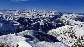
The Cantabrian Mountains or Cantabrian Range are one of the main systems of mountain ranges in Spain. They stretch for over 300 km (180 miles) across northern Spain, from the western limit of the Pyrenees to the Galician Massif in Galicia, along the coast of the Cantabrian Sea. Their easternmost end meets the Sistema Ibérico.

Peñamellera Baja is a municipality in the Autonomous Community of the Principality of Asturias, Spain. It is borderered to the north by Llanes and Ribadedeva, to the west by Peñamellera Alta, and to the east and south by the Autonomous Community of Cantabria.

Torrelavega is a municipality and important industrial and commercial hub in the single province Autonomous Community of Cantabria, northern Spain.

The Battle of Santander was fought in the War in the North campaign of the Spanish Civil War during the summer of 1937. Santander's fall on 26 August assured the Nationalist conquest of the province of Santander, now Cantabria. The battle devastated the Republic's "Army of the North"; 60,000 soldiers were captured by the Nationalists.

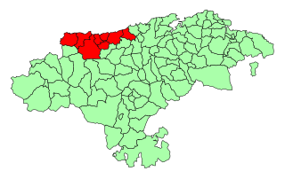
Campoo is a comarca (district) of Cantabria (Spain) located in the High Ebro. With an area of slightly more than 1,000 km2, it includes the municipalities of Hermandad de Campoo de Suso, Campoo de Enmedio, Campoo de Yuso, Valdeolea, Valdeprado del Río, Valderredible, Reinosa, Las Rozas de Valdearroyo, Santiurde de Reinosa, Pesquera, and San Miguel de Aguayo. The local inhabitants are called Campurrians . Its highest elevation is the Cuchillón peak, and the lowest is Pesquera, with the capital, Reinosa at 850 m.
The Western Coast of Cantabria is a comarca of said Spanish autonomous community which comprises the municipalities of Val de San Vicente, San Vicente de la Barquera, Valdáliga, Comillas, Udías, Ruiloba, Alfoz de Lloredo and Santillana del Mar.

Valles Pasiegos is an administrative comarca in Cantabria, Spain. It is formed by the valleys of the Pas and Miera rivers, each one being a natural comarca of its own.

The Valleys of the Saja and Nansa Rivers comprise an administrative comarca in Cantabria, Spain. It is formed by the valleys of said rivers, each one being a natural comarca of its own.

Trasmiera is a historic comarca of Cantabria (Spain), located to the east of the Miera River, reaching the western side of the Asón. It extends between the bays of Santander and Santoña, occupying most of the Eastern seaboard of Cantabria. This piece of coast is known for its cliffs and fine beaches, such as those of Langre, Loredo, Isla, Noja and Berria. Towards the interior, the comarca offers large prairies as well as considerable hotel and camping development.

Potes is a municipality in the autonomous community of Cantabria in Spain. It is the capital of the Comarca of Liébana and is located in the centre of it. It is bordered to the north by Cillorigo de Liébana, to the west by Camaleño, to the south by Vega de Liébana and to the east by Cabezón de Liébana.

Val de San Vicente is a municipality located in the autonomous community of Cantabria, Spain.

Suances is a municipality in Cantabria Province, Spain.

Rionansa is a municipality located in the autonomous community of Cantabria, Spain.
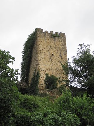
In Cantabria, there is a big number of fortified towers that fulfilled functions of housing and defense. These buildings, generally battlements, were erected mostly between the 13th and 15th centuries by noble families and influenced significantly in the architecture of Cantabria, passing some to be forts-houses, prelude to the future casona montañesa. A curious fact is that there are not in the region circular towers, as yes happens in the neighboring community of Asturias. Currently of the towers that survives several are in a deplorable condition.

The Latarmá, Latarma or Arria river is a fluvial course in Cantabria, Spain. It is a tributary of the Lamasón River and a subaffluent of the Nansa River, to whose river basin it belongs. Measuring 9 kilometres (5.6 mi) in length, it rises from an altitude of 339 metres (1,112 ft) to 180 metres (590 ft) at discharge.

The Nine Valleys lawsuit or simply Valleys lawsuit was a process that confronted the Nine Valleys of the Asturias de Santillana with the Dukedom of the Infantado. Begun in 1544 and it was ruled in 1581 in favor of the Nine Valleys. Its importance was capital in the process of the territorial configuration of Cantabria, since he achieved the independence of the valleys, constituted in the province of the Nine Valleys in 1589, germ in turn of the province of Cantabria of 1778, and caused the retreat of the manorial domains in the region. His memorial occupies 178 folios.

The Hermandad of the Cuatro Villas de la Costa de la Mar, also cited under the name Cuatro Villas de la Costa de Cantabria, was a medieval and modern administrative entity that grouped the coastal cities of the north of the kingdom of Castile, all of them part of present-day Cantabria; namely, from west to east: San Vicente de la Barquera, Santander, Laredo, and Castro-Urdiales. At the end of the 15th century, it became part of the corregimiento of the Cuatro Villas along with other territories in the north of the Iberian Peninsula. In 1514 the province was renamed the corregimiento de las Tres Villas de la Costa, by separation from the town of San Vicente, which rejoined in 1521. Towns twinned since the 13th century, its foundation as a corregimiento dates back to the reign of the Catholic Monarchs, around 1496, surviving until its inclusion in the province of Cantabria in 1778.

Viveda is a Lugar of the municipality of Santillana del Mar. It borders the towns of Barreda, Queveda and Camplengo, and Hinojedo. It is located 4 km from the municipal capital, Santillana del Mar, 3 km from the nearest city, Torrelavega, and about 22 km from Santander, Spain.

The Count of Castañeda, ruled by the Counts of Castañeda, a Spanish noble title of late medieval origin, was the first physical territory granted to an aristocrat in the region now occupied by the autonomous community of Cantabria. It initially belonged to the Manrique family. Geographically, it was located in territory originally belonging to the Asturias de Santillana comarca, bordering to the west with the marquisate of Santillana. The nobility title was used for centuries by the eldest sons of the holders of the marquisate of Aguilar de Campoo, first class Grandee of Spain, nowadays, both dignities are separated.
