This article may be confusing or unclear to readers.(February 2013) |
There are a number of explanations of the asymmetry of the Intertropical Convergence Zone (ITCZ), known by sailors as the Doldrums.
This article may be confusing or unclear to readers.(February 2013) |
There are a number of explanations of the asymmetry of the Intertropical Convergence Zone (ITCZ), known by sailors as the Doldrums.
The ITCZ would be expected to overlie the geographic equator according to symmetric solar radiation. [1] However, the ITCZ is mostly perennial in the northern hemisphere and in the eastern Pacific and Atlantic Oceans. [2] [3] It was originally explained by the asymmetrical distribution of continents. However, the distribution of land and ocean is severely asymmetric in the Indian Ocean, yet the ITCZ moves back and forth there between the southern and northern hemispheres. [4] Continents surround the Indian Ocean and monsoons prevail. Where the thermocline is deeper indicates that there is a weaker interaction between atmosphere and ocean. Due to the relatively small scale and deep thermocline in the Indian Ocean, there will be less asymmetric effects. In the middle latitude Pacific and Atlantic Ocean, because of the large scale easterly wind system and the western continents boundaries, the thermocline is definitely shallower in eastern part. Thus, the asymmetry is obvious in the eastern Pacific and Atlantic Ocean. There are two factors that are acknowledged by oceanographers and meteorologists: the interactions between ocean and atmosphere and the geometries of the continents. [5]
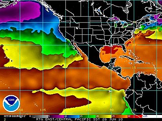
According to observations, the Sea Surface Temperature (SST) of ITCZ in the Northern Hemisphere is higher than the same latitude in the Southern Hemisphere. The asymmetry of ITCZ is triggered by the asymmetric SST distribution, which has been verified by General Circulation Model (GCM). [6]
What is more, because the Cross Equator SST Gradient (CESG) is southward, the cross equator northward wind, which decelerates trade winds north of the equator and accelerates those south of the equator due to Coriolis force, is originated. Thus the evaporation of the northern tropics is weakened, thereby cooling down the northern tropical SST slightly. Vice versa, SST of southern part to the equator is much reduced. Therefore, SST of northern tropical is much higher, and higher than southern tropical, by which increases the CESG. As a result, this positive feedback, which is defined as Wind-Evaporation-SST (WES) will intensify this process. [7]
In this way, the WES keeps the ITCZ north of the equator. And the precondition of WES is the asymmetric distribution of SST, and WES also strengthens this process. According to the observation of equatorial upwelling and obvious asymmetry of the ITCZ in the Pacific and Atlantic, it is inferred that it is the equatorial upwelling that prevents the ITCZ being created at the equator. [8] To explain this simply, upwelling brings cold water to the surface, which will cool the above atmosphere and make it stable because of relative high air density due to low temperature. Thus, this area of the equator is different compared to the strong vertical convection and abundant precipitation of the ITCZ. As a result, the SST is latitudinally asymmetric. [1]

Upwelling is an oceanographic phenomenon that involves wind-driven motion of dense, cooler, and usually nutrient-rich water from deep water towards the ocean surface. It replaces the warmer and usually nutrient-depleted surface water. The nutrient-rich upwelled water stimulates the growth and reproduction of primary producers such as phytoplankton. The biomass of phytoplankton and the presence of cool water in those regions allow upwelling zones to be identified by cool sea surface temperatures (SST) and high concentrations of chlorophyll a.

Physical oceanography is the study of physical conditions and physical processes within the ocean, especially the motions and physical properties of ocean waters.

The Intertropical Convergence Zone, known by sailors as the doldrums or the calms because of its monotonous windless weather, is the area where the northeast and the southeast trade winds converge. It encircles Earth near the thermal equator though its specific position varies seasonally. When it lies near the geographic Equator, it is called the near-equatorial trough. Where the ITCZ is drawn into and merges with a monsoonal circulation, it is sometimes referred to as a monsoon trough, a usage that is more common in Australia and parts of Asia.

A tropical wave, in and around the Atlantic Ocean, is a type of atmospheric trough, an elongated area of relatively low air pressure, oriented north to south, which moves from east to west across the tropics, causing areas of cloudiness and thunderstorms. Tropical waves form in the easterly flow along the equatorial side of the subtropical ridge or belt of high air pressure which lies north and south of the Intertropical Convergence Zone (ITCZ). Tropical waves are generally carried westward by the prevailing easterly winds along the tropics and subtropics near the equator. They can lead to the formation of tropical cyclones in the north Atlantic and northeastern Pacific basins. A tropical wave study is aided by Hovmöller diagrams, a graph of meteorological data.

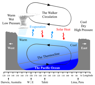
The Walker circulation, also known as the Walker cell, is a conceptual model of the air flow in the tropics in the lower atmosphere (troposphere). According to this model, parcels of air follow a closed circulation in the zonal and vertical directions. This circulation, which is roughly consistent with observations, is caused by differences in heat distribution between ocean and land. It was discovered by Gilbert Walker. In addition to motions in the zonal and vertical direction the tropical atmosphere also has considerable motion in the meridional direction as part of, for example, the Hadley Circulation.
The North Equatorial Current (NEC) is a westward wind-driven current mostly located near the equator, but the location varies from different oceans. The NEC in the Pacific and the Atlantic is about 5°-20°N, while the NEC in the Indian Ocean is very close to the equator. It ranges from the sea surface down to 400 m in the western Pacific.

The Equatorial Counter Current is an eastward flowing, wind-driven current which extends to depths of 100–150 metres (330–490 ft) in the Atlantic, Indian, and Pacific Oceans. More often called the North Equatorial Countercurrent (NECC), this current flows west-to-east at about 3-10°N in the Atlantic, Indian Ocean and Pacific basins, between the North Equatorial Current (NEC) and the South Equatorial Current (SEC). The NECC is not to be confused with the Equatorial Undercurrent (EUC) that flows eastward along the equator at depths around 200 metres (660 ft) in the western Pacific rising to 100 metres (330 ft) in the eastern Pacific.
The North Brazil Current (NBC) is a warm water ocean current that is part of the southwestern North Atlantic Gyre. It begins when the westward moving Atlantic South Equatorial Current splits in half and flows northwestward, following the coastline of north Brazil. It ends at the border of Brazil and Guiana, where it is renamed the Guiana Current. It is predominantly a salt water current, but it does help transport fresh water from the Amazon River northward.

A convergence zone in meteorology is a region in the atmosphere where two prevailing flows meet and interact, usually resulting in distinctive weather conditions. This causes a mass accumulation that eventually leads to a vertical movement and to the formation of clouds and precipitation. Large-scale convergence, called synoptic-scale convergence, is associated with weather systems such as baroclinic troughs, low-pressure areas, and cyclones. The large-scale convergence zone formed over the equator, the Intertropical Convergence Zone, has condensed and intensified as a result of the global increase in temperature. Small-scale convergence will give phenomena from isolated cumulus clouds to large areas of thunderstorms.

The geography of South America contains many diverse regions and climates. Geographically, South America is generally considered a continent forming the southern portion of the landmass of the Americas, south and east of the Colombia–Panama border by most authorities, or south and east of the Panama Canal by some. South and North America are sometimes considered a single continent or supercontinent, while constituent regions are infrequently considered subcontinents.

The Hadley cell, also known as the Hadley circulation, is a global-scale tropical atmospheric circulation that features air rising near the equator, flowing poleward near the tropopause at a height of 12–15 km (7.5–9.3 mi) above the Earth's surface, cooling and descending in the subtropics at around 25 degrees latitude, and then returning equatorward near the surface. It is a thermally direct circulation within the troposphere that emerges due to differences in insolation and heating between the tropics and the subtropics. On a yearly average, the circulation is characterized by a circulation cell on each side of the equator. The Southern Hemisphere Hadley cell is slightly stronger on average than its northern counterpart, extending slightly beyond the equator into the Northern Hemisphere. During the summer and winter months, the Hadley circulation is dominated by a single, cross-equatorial cell with air rising in the summer hemisphere and sinking in the winter hemisphere. Analogous circulations may occur in extraterrestrial atmospheres, such as on Venus and Mars.

The monsoon trough is a portion of the Intertropical Convergence Zone in the Western Pacific, as depicted by a line on a weather map showing the locations of minimum sea level pressure, and as such, is a convergence zone between the wind patterns of the southern and northern hemispheres.

Tropical instability waves, often abbreviated TIW, are a phenomenon in which the interface between areas of warm and cold sea surface temperatures near the equator form a regular pattern of westward-propagating waves. These waves are often present in the Atlantic Ocean, extending westward from the African coast, but are more easily recognizable in the Pacific, extending westward from South America. They have an average period of about 30 days and wavelength of about 1100 kilometers, and are largest in amplitude between June and November. They are also largest during La Niña conditions, and may disappear when strong El Niño conditions are present.
The Atlantic Equatorial Mode or Atlantic Niño is a quasiperiodic interannual climate pattern of the equatorial Atlantic Ocean. It is the dominant mode of year-to-year variability that results in alternating warming and cooling episodes of sea surface temperatures accompanied by changes in atmospheric circulation. The term Atlantic Niño comes from its close similarity with the El Niño-Southern Oscillation (ENSO) that dominates the tropical Pacific basin. For this reason, the Atlantic Niño is often called the little brother of El Niño. The Atlantic Niño usually appears in northern summer, and is not the same as the Atlantic Meridional (Interhemispheric) Mode that consists of a north-south dipole across the equator and operates more during northern spring. The equatorial warming and cooling events associated with the Atlantic Niño are known to be strongly related to rainfall variability over the surrounding continents, especially in West African countries bordering the Gulf of Guinea. Therefore, understanding of the Atlantic Niño has important implications for climate prediction in those regions. Although the Atlantic Niño is an intrinsic mode to the equatorial Atlantic, there may be a tenuous causal relationship between ENSO and the Atlantic Niño in some circumstances.
The Tropical Atlantic SST Dipole refers to a cross-equatorial sea surface temperature (SST) pattern that appears dominant on decadal timescales. It has a period of about 12 years, with the SST anomalies manifesting their most pronounced features around 10–15 degrees of latitude off of the Equator. It is also referred to as the interhemispheric SST gradient or the Meridional Atlantic mode.
The Tropical Atlantic Variability (TAV) is influenced by internal interaction and external effects. TAV can be discussed in different time scales: seasonal and interannual. tav can be discussed in different time scales:seasonal and interannual.and external effects.
A Wind generated current is a flow in a body of water that is generated by wind friction on its surface. Wind can generate surface currents on water bodies of any size. The depth and strength of the current depend on the wind strength and duration, and on friction and viscosity losses, but are limited to about 400 m depth by the mechanism, and to lesser depths where the water is shallower. The direction of flow is influenced by the Coriolis effect, and is offset to the right of the wind direction in the Northern Hemisphere, and to the left in the Southern Hemisphere. A wind current can induce secondary water flow in the form of upwelling and downwelling, geostrophic flow, and western boundary currents.

Pacific Meridional Mode (PMM) is a climate mode in the North Pacific. In its positive state, it is characterized by the coupling of weaker trade winds in the northeast Pacific Ocean between Hawaii and Baja California with decreased evaporation over the ocean, thus increasing sea surface temperatures (SST); and the reverse during its negative state. This coupling develops during the winter months and spreads southwestward towards the equator and the central and western Pacific during spring, until it reaches the Intertropical Convergence Zone (ITCZ), which tends to shift north in response to a positive PMM.
Ocean dynamical thermostat is a physical mechanism through which changes in the mean radiative forcing influence the gradients of sea surface temperatures in the Pacific Ocean and the strength of the Walker circulation. Increased radiative forcing (warming) is more effective in the western Pacific than in the eastern where the upwelling of cold water masses damps the temperature change. This increases the east-west temperature gradient and strengthens the Walker circulation. Decreased radiative forcing (cooling) has the opposite effect.
The recharge oscillator model for El Niño–Southern Oscillation (ENSO) is a theory described for the first time in 1997 by Jin., which explains the periodical variation of the sea surface temperature (SST) and thermocline depth that occurs in the central equatorial Pacific Ocean. The physical mechanisms at the basis of this oscillation are periodical recharges and discharges of the zonal mean equatorial heat content, due to ocean-atmosphere interaction. Other theories have been proposed to model ENSO, such as the delayed oscillator, the western Pacific oscillator and the advective reflective oscillator. A unified and consistent model has been proposed by Wang in 2001, in which the recharge oscillator model is included as a particular case.
{{cite book}}: |work= ignored (help)