
Madhubani is a town with municipality in Madhubani district in the Indian state of Bihar. It is the district headquarters. It lies 26 km northeast of Darbhanga town and was part of the erstwhile 'Bettiah Raj'. Internal disputes and family quarrels divided the Bettiah Raj in course of time. The Madhuban Raj in Madhubani was created as a consequence. The word "Madhuban" means "forest of honey" from which Madhubani is derived, but sometimes it is also known as "madhu"+"vaani" meaning "sweet" "voice/language". Madhubani is the cultural heart of Mithilanchal, being the birthplace of many literary people and home to Madhubani Paintings. It is said to be that Madhubani is the world's second city who adopted democracy. It shares a land boundary with Nepal. It is the core heart of Mithlanchal region and it is known for its hospitality culture. It is also known for its diverse food, culture and sweet Maithali language. Famous poets like Kalidas and Vidyapati emerged from this region only. This region is marked 4th in pisiculture in INDIA.
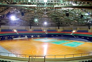
G. M. C. Balayogi SATS Indoor Stadium is an indoor arena located in Hyderabad, India. It holds 5,000 people. It is located in the Gachibowli suburb. The indoor stadium is located beside the Hyderabad International Institute of Information Technology. The venue hosted the 2009 BWF World Championships. It is one of the home arenas for the India's prime basketball league, the UBA Pro Basketball League. In 2017, 3rd edition of TEDxHyderabad was conducted in Gachibowli Indoor Stadium.

Chichli is a census town in Narsimhapur district in the state of Madhya Pradesh, India.

Dhandhuka is a city and a municipality in Ahmedabad district in the state of Gujarat, India.

Falakata is a census town of Alipurduar subdivision in Alipurduar district in the state of West Bengal, India.
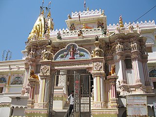
Gadhada is a city and a municipality in Botad District in the state of Gujarat, India. Gadhada is situated at bank of River Ghela.
Gariadhar is a city and a municipality in Bhavnagar district in the state of Gujarat, India.

Haldibari is a city and a municipality in Cooch Behar district in the Indian state of West Bengal.
Harij is a city and a municipality in Patan district in the Indian state of Gujarat.

Kakrala is a city and municipal board in Badaun district in India state of Uttar Pradesh. It is located to the East of the district Headquarter. It is 12 km from Badaun. the term Kakrala originates from the apbhramsha Kakrabad. The most population of this town are consisting Muslims, as the Vibrant culture of India suggests, the town is also diverse in terms of religion, festivals etc. India has a unique culture of Unity in diversity, the same phenomenon has occurred in this town also. In the vista of towns of this state one distinguishes Kakrala as quite significant. In fact, Kakrala is the name of a city which has a well British era municipal board.It is situated approximately at 27.9 deg N 79.2 deg E. It has an average height of 160 meters or 524 feet. The discovery of Indian town or city becomes complete with the knowledge of its current demographic scenario. In order to meet the objectives, numerous demographers have organized surveys and research works and thus brought out significant information about Kakrala city. Regarding this, the Census report is praiseworthy. Data like population, literacy rate etc. can be deduced from this report. According to this report, Kakrala city has got a total population measurement of 40,380. Females are less in number than their male counterparts. This becomes obvious from the literacy rates of both males and females. In other words, male populace constitutes 53 %, while the total population of females comprises 57 %. Information about the children who are residing in Kakrala too can be deduced. Thus kids who are below six years of age constitute 20 % of the total population of Kakrala. Literacy rate adds to the information of this Kakrala city. The most of the population of the city belongs to the Muslim Rajputs. Kakrala has done a important great war with british government from 1914 to 1919.
Kopaganj is a town and a nagar panchayat in Mau district in the Indian state of Uttar Pradesh.
Ranapur is a town and a nagar panchayat in Jhabua district in the Indian state of Madhya Pradesh.

Partridge Township is located in Woodford County, Illinois. As of the 2010 census, its population was 593 and it contained 243 housing units.

Fatehabad is a town and a municipal committee in Fatehabad district in the state of Haryana, India.
Kathgarh is a town and union council on Dera Ismail Khan District in the North-West Frontier Province of Pakistan. Its is built to the west shores of the river Beas. It is located at 32°9'2N 71°1'18E and has an altitude of 173 metres.

Kobylniki is a village in the administrative district of Gmina Poddębice, within Poddębice County, Łódź Voivodeship, in central Poland. It lies approximately 8 kilometres (5 mi) north-west of Poddębice and 44 km (27 mi) north-west of the regional capital Łódź.
Łęczno is a village in the administrative district of Gmina Białogard, within Białogard County, West Pomeranian Voivodeship, in north-western Poland. It lies approximately 5 kilometres (3 mi) south-west of Białogard and 110 km (68 mi) north-east of the regional capital Szczecin.

McConnel Place is an unincorporated community in El Dorado County, California. It lies at an elevation of 4600 feet.

Campo Felice is a karstic plateau in the central Appennines, included in the province of L'Aquila, Abruzzo, central Italy.


