Greater Manchester is a metropolitan and ceremonial county in North West England, with a population of 2.8 million; comprising ten metropolitan boroughs: Manchester, Salford, Bolton, Bury, Oldham, Rochdale, Stockport, Tameside, Trafford and Wigan. The county was created on 1 April 1974, as a result of the Local Government Act 1972, and has been covered by a combined authority on 1 April 2011. Greater Manchester is formed from parts of the historic counties of Cheshire, Lancashire and the West Riding of Yorkshire.

Leigh is a town in the Metropolitan Borough of Wigan, Greater Manchester, England, on low-lying land northwest of Chat Moss.

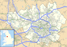
The Metropolitan Borough of Wigan is a metropolitan borough of Greater Manchester, in North West England. It is named after the main settlement of Wigan but covers a far larger area, extending up to 9 miles eastwards, including the towns of Atherton, Ashton-in-Makerfield, Golborne, Hindley, Ince-in-Makerfield, Leigh and Tyldesley. The borough also covers the villages and suburbs of Abram, Aspull, Astley, Bryn, Hindley Green, Lowton, Mosley Common, Orrell, Pemberton, Shevington, Standish, Winstanley and Worsley Mesnes. The borough is also the second-most populous district in Greater Manchester.

Farnworth is a town in the Metropolitan Borough of Bolton, Greater Manchester, England, 2.3 miles (3.7 km) southeast of Bolton, 4.3 miles south-west of Bury (7 km), and 7.5 miles (12.1 km) northwest of Manchester.

Westhoughton is a town and civil parish in the Metropolitan Borough of Bolton, Greater Manchester, England, 4 miles (6 km) southwest of Bolton, 5 miles (8 km) east of Wigan and 13 miles (21 km) northwest of Manchester.

Hindley is a town within the Metropolitan Borough of Wigan in Greater Manchester, England. It is three miles (4.8 km) east of Wigan and covers an area of 2,580 acres (1,044 ha). Within the boundaries of the historic county of Lancashire, Hindley borders the towns and villages of Ince-in-Makerfield, Aspull, Westhoughton, Atherton and Westleigh in the former borough of Leigh. In 2001, Hindley had a population of 23,457, increasing to 28,000 at the 2011 Census. It forms part of the wider Greater Manchester Urban Area.
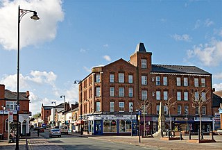
Atherton is a town in the Metropolitan Borough of Wigan in Greater Manchester, England and historically part of Lancashire. The town, including Hindsford, Howe Bridge and Hag Fold, is 5 miles (8.0 km) south of Bolton, 7 miles (11.3 km) east of Wigan, and 10 miles (16.1 km) northwest of Manchester. From the 17th century, for about 300 years, Atherton was known as Chowbent, which was frequently shortened to Bent, the town's old nickname. During the Industrial Revolution, the town was a key part of the Manchester Coalfield.

Pendlebury is a town in the City of Salford, Greater Manchester, England. The population at the 2011 Census was 13,069. It lies 4 miles (6.4 km) north-west of Manchester city centre, 3 miles (4.8 km) north-west of Salford and 6 miles (9.7 km) south-east of Bolton.

The Greater Manchester Built-up Area is an area of land defined by the Office for National Statistics (ONS), consisting of the large conurbation that encompasses the urban element of the city of Manchester and the metropolitan area that forms much of Greater Manchester in North West England. According to the United Kingdom Census 2011, the Greater Manchester Built-up Area has a population of 2,553,379 making it the second most populous conurbation in the United Kingdom after the Greater London Built-up Area. This was an increase of 14% from the population recorded at the United Kingdom Census 2001 of 2,240,230, when it was known as the Greater Manchester Urban Area.
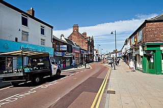
Tyldesley is a market town in Metropolitan Borough of Wigan in Greater Manchester, England. Within the boundaries of the historic county of Lancashire, it is north of Chat Moss near the foothills of the West Pennine Moors, 8 miles (12.9 km) southeast of Wigan and 9 miles (14.5 km) northwest of Manchester. At the United Kingdom Census 2001, the Tyldesley built-up area subdivision, excluding Shakerley, had a population of 16,142.

The Manchester–Southport line is a railway line in the north-west of England, operated by Northern Trains. It was originally built as the Manchester and Southport Railway. The section between Wigan and Salford is also known locally as the Atherton Line.

Bradshaw Gass & Hope is an English architectural practice founded in 1862 by Jonas James Bradshaw. The style "Bradshaw Gass & Hope" was adopted after his death referring to the remaining partners John Bradshaw Gass and Arthur John Hope.
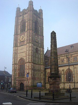
St John the Baptist's Church is in Market Place, Atherton, Greater Manchester, England. It is an active Anglican parish church in the archdeaconry of Salford, and diocese of Manchester. Together with St George's and St Philip's Churches in Atherton and St Michael and All Angels at Howe Bridge, the church is part of the United Benefice of Atherton and Hindsford with Howe Bridge. It is recorded in the National Heritage List for England as a designated Grade II listed building.

Howe Bridge is a suburb of Atherton, Greater Manchester, England. Historically within Lancashire, it is situated to the south west of Atherton town centre on the B5215, the old turnpike road from Bolton to Leigh. The settlement was built as a model pit village by the owners of Atherton Collieries.

James Caldwell Prestwich (1852–1940) was an English architect. He was born in Atherton, Lancashire and educated at Leigh and Nantwich Grammar Schools. He trained to be an architect in London and returned to Leigh in 1875 to start an architectural practice which he worked in until 1930 and which was continued by his son. He produced many buildings in Leigh and Nicholas Pevsner remarked that, "Any building of any merit which is not a church or a mill is almost certainly by the local firm of J.C. Prestwich & Sons, capable – sometimes very capable – in a number of styles."
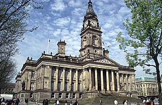
Bolton Town Hall in Victoria Square, Bolton, Greater Manchester, England, was built between 1866 and 1873 for the County Borough of Bolton to designs by William Hill of Leeds and George Woodhouse of Bolton. The town hall was extended in the 1930s to the designs of Bradshaw, Gass and Hope and has been designated a Grade II* listed building by English Heritage.
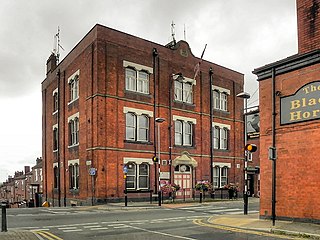
Tyldesley Town Hall is a municipal building in Elliott Street, Tyldesley, Greater Manchester, England. Initially the local Liberal Party Club, the town hall went on to become the meeting place of Tyldesley Urban District Council.
Westhoughton Town Hall is a municipal building in Market Street, Westhoughton, Greater Manchester, England. The town hall is the meeting place of Westhoughton Town Council.