
The Red River Gorge is a canyon system on the Red River in east-central Kentucky. Geologically, it is part of the Pottsville Escarpment.

Onkaparinga River National Park is a protected area in the Australian state of South Australia located about 32 kilometres (20 mi) south of Adelaide city centre. It extends over the floodplain of the Onkaparinga River east of Main South Road.
Gorges State Park is a 7,709-acre (31.20 km2) North Carolina state park in Transylvania County, North Carolina in the United States and along with other conservation lands is part of a 100,000+ acre conservation corridor stretching some 80 miles along the NC/SC state line. The land, along Jocassee Gorges, was purchased by the state from Duke Energy Corporation in 1999. It is North Carolina's westernmost state park and one of the state's newest. The park is adjacent to part of the Pisgah National Forest and the N.C. Wildlife Resources Commission's Toxaway Game Land. Gorges State Park provides the principal access to the Horsepasture River on these adjoining public lands.
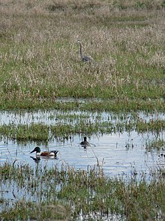
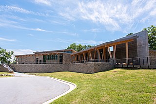
Ridgefield National Wildlife Refuge is a wildlife preserve, one of the national wildlife refuges operated by the United States Fish and Wildlife Service, located in the westernmost part of Clark County, Washington. The refuge protects more than 5,200 acres (2,100 ha) of marshes, grasslands, and woodlands. The refuge was established in 1965, in response to a need to establish vital winter habitat for wintering waterfowl with an emphasis on the dusky Canada goose whose nesting areas in Alaska were severely impacted by the violent earthquake of 1964. Ridgefield NWR is part of the Ridgefield National Wildlife Refuge Complex, headquartered in Ridgefield, Washington, which oversees the management of four refuges in the southwestern part of the state: Ridgefield, and three refuges in the Columbia River Gorge: Franz Lake, Pierce, and Steigerwald Lake. This place was closed in spring of 2019 to cut down Douglas fir and change the trail. In fall of 2020, the construction of a new multi-purpose building began. The new multi-purpose building will be a construction type V-B and consist of a 4,415 square foot single story building with an associated balcony and basement area. The building is being constructed to provide the fish and wildlife staff office space, meeting space, and an area for public visitors including volunteers and conservation partners.

The Justin P. Wilson Cumberland Trail State Park, commonly known as the Cumberland Trail, is a Tennessee hiking trail following a line of ridges and gorges along the eastern escarpment of the Cumberland Plateau and Cumberland Mountains in Tennessee. The trail begins at Cumberland Gap National Historical Park and ends at Chickamauga and Chattanooga National Military Park and Prentice Cooper Wildlife Management Area just outside Chattanooga, Tennessee. The trail travels through 11 Tennessee counties and two time zones.

The Little Pend Oreille National Wildlife Refuge is a wildlife preserve, one of the national wildlife refuges operated by the United States Fish and Wildlife Service. The refuge is located east of Colville, Washington, along the west slope of the Selkirk Mountain Range. It lies mostly in eastern Stevens County, with a small part extending eastward into western Pend Oreille County. It is the only mountainous, mixed-conifer forest refuge outside Alaska and the largest in Washington state.

Ashley National Forest is a National Forest located in northeastern Utah and southwestern Wyoming. Within the Forest's bounds are 1,382,346 acres (5,594 km2) of vast forests, lakes, and mountains, with elevations ranging from 6,000 to 13,500 feet. The Forest covers portions of Daggett, Duchesne, Summit, Uintah, and Utah counties in Utah and Sweetwater County in Wyoming. Some of the most popular landmarks located in the Forest include the Flaming Gorge National Recreation Area and the Uinta Mountains, which contains the highest mountain peak in Utah. The Forest also includes 276,175 acres (1,117.64 km2), or about 60.5%, of the High Uintas Wilderness. The headquarters for the Ashley National Forest are located in Vernal, Utah with ranger district offices in Vernal; Duchesne, Utah; Roosevelt, Utah; Manila, Utah; and Green River, Wyoming.

Tang-e Vashi is a gorge and mountain pass in the Alborz range of Iran (Persia). It is a popular tourist attraction in Tehran Province.

Sheep River Provincial Park is a provincial park located in Alberta, Canada, 23 kilometres (14 mi) west of Turner Valley on highway 546. It is part of the Kananaskis Country park system and encompasses a portion of the Sheep River valley.
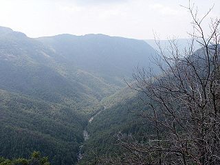
The Linville Gorge Wilderness is the third largest wilderness area in North Carolina and one of only two wilderness gorges in the Southern United States. Maintained by the United States Forest Service, it comprises 11,786 acres (47.7 km2) around the Linville River, and is situated inside the Pisgah National Forest. The river is approximately 1,400 feet below the ridge, thus hiking in and out of the Gorge is challenging and enjoyable for those who like serious hiking. The plant and animal community is extremely diverse, with a dense hardwood/pine forest and a wide variety of smaller trees and other plants as well as bear, fox, raccoon, trout, grouse, wild turkey, vultures, owls, hawks, copperheads, and timber rattlesnakes.

Bad Branch Falls State Nature Preserve is a forested gorge covering 2,639 acres near Whitesburg, KY in Letcher County, Kentucky. The deep and narrow gorge, adjacent to the Jefferson National Forest is carved into the face of Pine Mountain. Sandstone boulders and cliffs along with riglines and knobs provide views into the Appalachia area. The terrain is landscaped with streams, rivers, and a 60-foot waterfall. With a variety of habitat types, this nature preserve is home to many unique and unknown species of flora and fauna.

The Mark O. Hatfield Wilderness is a wilderness area located on the northern side of Mount Hood in the northwestern Cascades of the U.S. state of Oregon, near the Columbia River Gorge and within Mount Hood National Forest. Prior to Wilderness designation it was known as the Columbia Gorge Recreation Area.

Tekoa Mountain, 1,121 feet (342 m), is a dramatic, rocky high point overlooking the Westfield River Gorge at the eastern edge of the Berkshire plateau in the towns of Montgomery and Russell, Massachusetts, USA. Tekoa Mountain, very prominent from the "Jacob's Ladder" section of U.S. Route 20 in the town of Russell, is not a true mountain but a cleaver jutting from a dissected plateau; it was produced by glacial action and through continuous erosion by the Westfield River and Moose Meadow Brook before and after the last ice age.

John Bryan State Park is a 752-acre (304 ha) Ohio state park in Greene County, Ohio. The park surrounds Clifton Gorge, a deep cut of the Little Miami River between Yellow Springs and Clifton. The park contains a campground, and hiking and biking trails. The park also abuts the Clifton Gorge State Nature Preserve and Glen Helen Nature Preserve.

The Deschutes River State Recreation Area is a park at the confluence of the Deschutes and Columbia rivers in the U.S. state of Oregon. It is a few miles east of The Dalles. The 35.1-acre (14.2 ha) park offers opportunities for camping, fishing, hiking, mountain biking, and equestrian trail riding.

Havasu National Wildlife Refuge is a U.S. National Wildlife Refuge on the lower Colorado River in Arizona and California. It preserves habitat for desert bighorn sheep to the endangered southwestern willow flycatcher, birds and other animals. The refuge protects 30 river miles - 300 miles (480 km) of shoreline - from Needles, California, to Lake Havasu City, Arizona. One of the last remaining natural stretches of the lower Colorado River flows through the 20-mile-long (32 km) Topock Gorge.
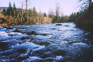
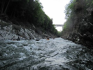
Kanaskat-Palmer State Park is a 320-acre (130 ha) Washington state park on the Green River in King County. The park has 2 miles (3.2 km) of river shoreline and offers picnicking, camping, 3 miles (4.8 km) of trails for hiking and biking, expert-level rafting and kayaking in the Green River Gorge, fishing, swimming, birdwatching, wildlife viewing, and horseshoes.
The word Atigun can refer to one of several place names in Alaska.
The Quechee State Park is located on US Route 4 in Quechee, Vermont. The park land is owned by the US Army Corps of Engineers and leased from by the State of Vermont. The park contains the Quechee Gorge, a popular Vermont tourist stop. The land was originally the site of the Dewey wool mill which ceased operation in 1952 and relocated to Enfield, New Hampshire. Shortly after the closing of the Mill the US Army Corps of Engineers acquired the property as part of its regional flood control plan. A hydroelectric dam sits at the north end of the gorge.

Dennis A. Cowals was a photojournalist who contributed many photos to the United States Environmental Protection Agency sponsored DOCUMERICA project. Hundreds of photos he took of Alaska during the construction of the Trans-Alaska Pipeline System have been published. He focused on both ground and aerial photos of geography, flora, and fauna. They are now in the public domain.

