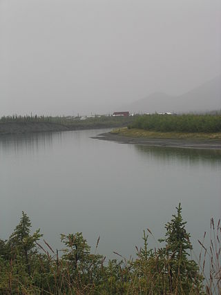
Cooper Landing is a census-designated place (CDP) in Kenai Peninsula Borough, Alaska, United States, about 100 miles (160 km) south of Anchorage, at the outlet of Kenai Lake into the Kenai River. The town was first settled in the 19th century by gold and mineral prospectors, and has become a popular summer tourist destination thanks to its scenic location and proximity to the salmon fishery of the Kenai River and Russian River. As of the 2010 census, the population in Cooper Landing was 289, down from 369 in 2000.
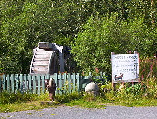
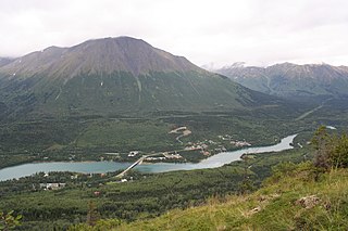
Moose Pass is a census-designated place (CDP) in Kenai Peninsula Borough, Alaska, United States. The population was 219 at the 2010 census, up from 206 in 2000.

Palmer is a city in and the borough seat of the Matanuska-Susitna Borough, Alaska, United States, located 42 miles (68 km) northeast of Anchorage on the Glenn Highway in the Matanuska Valley. It is the ninth-largest city in Alaska, and forms part of the Anchorage Metropolitan Statistical Area. As of the 2020 census, the population of the city is 5,888, down from 5,937 in 2010.

Susitna North is a census-designated place (CDP) in the Matanuska-Susitna Borough in the U.S. state of Alaska. It is part of the Anchorage, Alaska Metropolitan Statistical Area. The population was 1,564 at the 2020 census, up from 1,260 in 2010. The CDP was formerly named Y, for the intersection of the George Parks Highway and the Talkeetna Spur Road. In the immediate vicinity of this intersection is a community center of sorts, containing a health clinic, law enforcement, Susitna Valley High School and retail services for highway travelers such as gasoline and food.

Anaktuvuk Pass is a city in North Slope Borough, Alaska, United States. The population was 282 at the 2000 census and 324 as of the 2010 census.

The Municipality and Borough of Skagway is a first-class borough in Alaska on the Alaska Panhandle. As of the 2020 census, the population was 1,240, up from 968 in 2010. The population doubles in the summer tourist season in order to deal with more than 1,000,000 visitors each year. Incorporated as a borough on June 25, 2007, it was previously a city in the Skagway-Yakutat-Angoon Census Area. The most populated community is the census-designated place of Skagway.
Glennallen is a census-designated place (CDP) in the Copper River Census Area in the Unorganized Borough of the U.S. state of Alaska. As of the 2020 census, the population of the CDP was 439, down from 483 in 2010. It is the most populated community in the census area.

Bettles is a city in Yukon-Koyukuk Census Area, Alaska, United States. It is near Gates of the Arctic National Park and Preserve. The population was 23 at the 2020 census, up from 12 in 2010. It is the second smallest incorporated city in the state.

Coldfoot is a census-designated place (CDP) in Yukon-Koyukuk Census Area in the U.S. state of Alaska. The population was 34 at the 2020 census. It is said that the name was derived from travelers getting "cold feet" about making the 240-some-mile journey north to Deadhorse.

The James W. Dalton Highway, usually referred to as the Dalton Highway, is a 414-mile (666 km) road in Alaska. It begins at the Elliott Highway, north of Fairbanks, and ends at Deadhorse near the Arctic Ocean and the Prudhoe Bay Oil Fields. Once called the North Slope Haul Road, it was built as a supply road to support the Trans-Alaska Pipeline System in 1974. It is named after James Dalton, a lifelong Alaskan and an engineer who supervised construction of the Distant Early Warning Line in Alaska and, as an expert in Arctic engineering, served as a consultant in early oil exploration in northern Alaska. It is also the subject of the second episode of America's Toughest Jobs and the first episode of the BBC's World's Most Dangerous Roads.

Gates of the Arctic National Park and Preserve is an American national park that protects portions of the Brooks Range in northern Alaska. The park is the northernmost national park in the United States, situated entirely north of the Arctic Circle. The area of the park and preserve is the second largest in the U.S. at 8,472,506 acres, slightly larger in area than Belgium; the National Park portion is the second largest in the U.S., after the National Park portion of Wrangell–St. Elias National Park and Preserve.
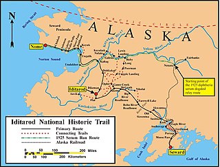
The Iditarod Trail, also known historically as the Seward-to-Nome Trail, is a thousand-plus mile (1,600 km) historic and contemporary trail system in the US state of Alaska. The trail began as a composite of trails established by Alaskan native peoples. Its route crossed several mountain ranges and valleys and passed through numerous historical settlements en route from Seward to Nome. The discovery of gold around Nome brought thousands of people over this route beginning in 1908. Roadhouses for people and dog barns sprang up every 20 or so miles. By 1918 World War I and the lack of 'gold fever' resulted in far less travel. The trail might have been forgotten except for the 1925 diphtheria outbreak in Nome. In one of the final great feats of dog sleds, twenty drivers and teams carried the life-saving serum 674 miles (1,085 km) in 127 hours. Today, the Iditarod Trail Sled Dog Race serves to commemorate the part the trail and its dog sleds played in the development of Alaska, and the route and a series of connecting trails have been designated Iditarod National Historic Trail.

Birch Creek is a 150-mile (240 km) tributary of the Yukon River in the U.S. state of Alaska. Beginning at the confluence of Ptarmigan and Eagle creeks near Porcupine Dome, it flows southwest, then south under the Steese Highway and into the Steese National Conservation Area. It then turns east, then north, again passing under the Steese Highway and entering the Yukon Flats National Wildlife Refuge. Turning northwest, it ends where it splits into two distributaries, Lower Mouth Birch Creek and Upper Mouth Birch Creek, near Birch Creek, Alaska. The distributaries flow into the Yukon River at separate locations downstream of Fort Yukon.
The Chandalar River is a 100-mile (160 km) tributary of the Yukon River in the U.S. state of Alaska. Its peak flow, recorded by the United States Geological Survey (USGS) between 1964 and 1974 at a stream gauge at Venetie, was 62,800 cubic feet per second (1,780 m3/s) on June 9, 1968.

Chugach State Park covers 495,204 acres covering a hilly region immediately east of Anchorage, in south-central Alaska.

Denali Highway is a lightly traveled, mostly gravel highway in the U.S. state of Alaska. It leads from Paxson on the Richardson Highway to Cantwell on the Parks Highway. Opened in 1957, it was the first road access to Denali National Park. Since 1971, primary park access has been via the Parks Highway, which incorporated a section of the Denali Highway from Cantwell to the present-day park entrance. The Denali Highway is 135 miles (217 km) in length.
The Stampede Trail is a remote road and trail located in the Denali Borough in the U.S. state of Alaska. Apart from a paved or maintained gravel road for 8 miles (13 km) between Eight Mile Lake and the trail's eastern end, the route consists of a primitive and at times dangerous hiking or ATV trail following the path of the original road, which has deteriorated over the years. The route ends at an abandoned antimony mine at 63.740739°N 150.379229°W along Stampede Creek, a couple miles past Stampede Airport's grass airstrip.
Little Susitna River (Dena'ina: Tsałtastnu) heads at Mint Glacier on Montana Peak, in Talkeetna Mountains at 61°51′30″N149°03′30″W, flows southwest to Cook Inlet, 13 miles (21 km) west of Anchorage, Alaska Cook Inlet Low.
The Sagavanirktok River or Sag River is a stream in the North Slope Borough of the U.S. state of Alaska. It is about 180 miles (290 km) long and originates on the north slope of the Brooks Range, flowing north to the Beaufort Sea near Prudhoe Bay. The Trans-Alaska Pipeline System and Dalton Highway roughly parallel it from Atigun Pass to Deadhorse.
The construction of the Trans-Alaska Pipeline System included over 800 miles (1,300 km) of oil pipeline, 12 pump stations, and a new tanker port. Built largely on permafrost during 1975–77 between Prudhoe Bay and Valdez, Alaska, the $8 billion effort required tens of thousands of people, often working in extreme temperatures and conditions, the invention of specialized construction techniques, and the construction of a new road, the Dalton Highway.

