Atlantic Park station (LIRR)

Last updated
Atlantic Park
General information
Line(s) Far Rockaway Branch
Tracks2
History
OpenedMay 1875
Closed1901 or 1929

Atlantic Park was a station on the Long Island Rail Road's former Far Rockaway Branch route in the Rockaways in Queens County, New York City, New York, United States. It has now been abandoned and destroyed.

Contents

Location Uncertainty

Where the station was located is uncertain. Some sources label its placement as past Neptune House in or next to Belle Harbor, while some say it was located on Rockaway Freeway in between Edgemere and Far Rockaway stations or on Rockaway Freeway between Edgemere and South Side Pavilion stations, though the last two could very well be two descriptions of the same place. [1]

History

The station opened in May 1875. [2] It closed sometime before 1929 [3] (if its placement was near Edgemere) or 1901 [4] (if its placement was past Neptune House.) [5] It was not raised up above ground with the rest of the line as part of its grade-separation.

Related Research Articles

<span class="mw-page-title-main">Long Island Rail Road</span> Commuter rail system on Long Island, New York

The Long Island Rail Road, often abbreviated as the LIRR, is a commuter rail system in the southeastern part of the U.S. state of New York, stretching from Manhattan to the eastern tip of Suffolk County on Long Island. With an average weekday ridership of 354,800 passengers in 2016, it is the busiest commuter railroad in North America. It is also one of the world's few commuter systems that runs 24/7 year-round. It is publicly owned by the Metropolitan Transportation Authority, which refers to it as MTA Long Island Rail Road. In 2022, the system had a ridership of 70,342,700, or about 239,300 per weekday as of the fourth quarter of 2022.

<span class="mw-page-title-main">Proposed expansion of the New York City Subway</span>

Since the opening of the original New York City Subway line in 1904, and throughout the subway's history, various official and planning agencies have proposed numerous extensions to the subway system. The first major expansion of the subway system was the Dual Contracts, a set of agreements between the City of New York and the IRT and the BRT. The system was expanded into the outer reaches of the Bronx, Brooklyn, and Queens, and it provided for the construction of important lines in Manhattan. This one expansion of the system provided for a majority of today's system.

<span class="mw-page-title-main">Far Rockaway, Queens</span> Neighborhood of Queens in New York City

Far Rockaway is a neighborhood on the eastern part of the Rockaway peninsula in the New York City borough of Queens. It is the easternmost section of the Rockaways. The neighborhood extends from Beach 32nd Street east to the Nassau County line. Its southern boundary is the Atlantic Ocean; it is one of the neighborhoods along Rockaway Beach.

<span class="mw-page-title-main">Atlantic Branch</span> Long Island Rail Road branch

The Atlantic Branch is an electrified rail line owned and operated by the Long Island Rail Road in the U.S. state of New York. It is the only LIRR line with revenue passenger service in the borough of Brooklyn.

<span class="mw-page-title-main">Far Rockaway Branch</span> Long Island Rail Road branch

The Far Rockaway Branch is an electrified rail line and service owned and operated by the Long Island Rail Road in the U.S. state of New York. The branch begins at Valley Interlocking, just east of Valley Stream station. From Valley Stream, the line heads south and southwest through southwestern Nassau County, ending at Far Rockaway in Queens, thus reentering New York City. LIRR maps and schedules indicate that the Far Rockaway Branch service continues west along the Atlantic Branch to Jamaica. This two-track branch provides all day service in both directions to Grand Central Madison and Penn Station, both in Midtown Manhattan

<span class="mw-page-title-main">Far Rockaway station (LIRR)</span> Long Island Rail Road station in Queens, New York

Far Rockaway is the terminus of the Long Island Rail Road's Far Rockaway Branch in the Far Rockaway neighborhood of Queens in New York City. The station is located at Nameoke Avenue and Redfern Avenue.

<span class="mw-page-title-main">Beach 36th Street station</span> New York City Subway station in Queens

The Beach 36th Street station is a station on the IND Rockaway Line of the New York City Subway. The station is located at the intersection of Beach 36th Street and Rockaway Freeway in Edgemere, Queens. It is served by the A train at all times.

<span class="mw-page-title-main">Beach 25th Street station</span> New York City Subway station in Queens

The Beach 25th Street station is a station on the IND Rockaway Line of the New York City Subway, located in Queens on the Rockaway Freeway at Beach 25th Street. It is served by the A train at all times. There are two tracks and two side platforms.

<span class="mw-page-title-main">Far Rockaway–Mott Avenue station</span> New York City Subway station in Queens

The Far Rockaway–Mott Avenue station is the eastern terminal station of the New York City Subway's IND Rockaway Line. Originally a Long Island Rail Road station, it is currently the easternmost station in the New York City Subway. It is served by the A train at all times.

<span class="mw-page-title-main">Long Beach Branch</span> Long Island Rail Road branch

The Long Beach Branch is an electrified rail line and service owned and operated by the Long Island Rail Road in the U.S. state of New York. The branch begins at Valley Interlocking, just east of Valley Stream station, where it merges with the Far Rockaway Branch to continue west as the Atlantic Branch. East from there the Long Beach Branch parallels the Montauk Branch to Lynbrook station, where it turns south toward Long Beach station. Trains operating on the Long Beach Branch continue west of Valley Stream via the Atlantic Branch to Jamaica station, with most continuing on to Grand Central or Penn Station in Midtown Manhattan. In 2018, the branch recorded an annual ridership of 4,849,085 based on ticket sales, down 1% from 2017.

The IND Rockaway Line is a rapid transit line of the IND Division of the New York City Subway, operating in Queens. It branches from the IND Fulton Street Line at Rockaway Boulevard, extending over the Jamaica Bay, into the Rockaways. The A train serves the line on the Far Rockaway–Mott Avenue branch and north of Hammels Wye. The Rockaway Park Shuttle runs between Broad Channel and Rockaway Park–Beach 116th Street. Five rush hour A trains provide service between Rockaway Park and Manhattan in the peak direction.

<span class="mw-page-title-main">Rockaway Beach Branch</span> Former Long Island Rail Road branch (closed 1962)

The Rockaway Beach Branch was a rail line owned and operated by the Long Island Rail Road in Queens, New York City, United States. The line left the Main Line at Whitepot Junction in Rego Park heading south via Ozone Park and across Jamaica Bay to Hammels in the Rockaways, turning west there to a terminal at Rockaway Park. Along the way it connected with the Montauk Branch near Glendale, the Atlantic Branch near Woodhaven, and the Far Rockaway Branch at Hammels.

<span class="mw-page-title-main">Woodhaven Junction station</span>

Woodhaven Junction was a station complex on the Atlantic Branch and Rockaway Beach Branch of the Long Island Rail Road, located at Atlantic Avenue between 98th and 100th Streets in Woodhaven, Queens, New York City. The elevated Rockaway Beach station was closed in 1962 along with the rest of the branch, while the underground Atlantic Branch station was closed and abandoned on January 7, 1977.

<span class="mw-page-title-main">Ozone Park station (LIRR)</span>

Ozone Park is a former Long Island Rail Road station in New York City. Located at 99th Street and 101st Avenue in Ozone Park, Queens, it was a major station along the Rockaway Beach Branch until the line's closure in 1962.

<span class="mw-page-title-main">Brooklyn Manor station</span> Former LIRR station (closed 1962)

Brooklyn Manor was a station on the Long Island Rail Road's Rockaway Beach Branch located on the south side of Jamaica Avenue at 100th Street, straddling the border between Richmond Hill and Woodhaven in Queens, New York City. The station name referred to the nearby Brooklyn Manor section of Woodhaven, originally a 603-lot development bounded by Woodhaven Boulevard to the west, 96th/98th Streets to the east, Forest Park to the north, and Jamaica Avenue to the south. The station opened in January 1911, and was constructed as a replacement for the Brooklyn Hills station, which was located 3,000 feet (910 m) to the north. This station closed along with the rest of the Rockaway Beach Branch in 1962, and was subsequently demolished.

Higbie Avenue was a railroad station along the Atlantic Branch of the Long Island Rail Road, in Queens, New York City. The station was located on 140th Avenue and Edgewood Avenue in the Springfield section of Queens, New York City between Locust Manor and Laurelton stations.

<span class="mw-page-title-main">Hamilton Beach station</span>

Hamilton Beach was a former Long Island Rail Road station on the Rockaway Beach Branch in Queens, New York City. It was located between two streets in Hamilton Beach, Queens, one of which no longer exists and is part of land owned by JFK Airport.

Hammels was a Long Island Rail Road station on the Rockaway Beach Branch in Hammels, Queens. It was located at what is today Beach 84th Street at the west leg of the Hammels Wye.

<span class="mw-page-title-main">Woodhaven and Cross Bay Boulevards buses</span> Bus routes in Queens, New York

The Q11, Q21, Q52, and Q53 bus routes constitute a public transit corridor running along Woodhaven and Cross Bay Boulevards in Queens, New York City. The corridor extends primarily along the length of the two boulevards through "mainland" Queens, a distance of 6 miles (9.7 km) between Elmhurst and the Jamaica Bay shore in Howard Beach. The Q52 and Q53 buses, which provide Select Bus Service along the corridor, continue south across Jamaica Bay to the Rockaway peninsula, one of the few public transit options between the peninsula and the rest of the city.

<span class="mw-page-title-main">Edgemere Landfill</span> Former landfill in Queens, New York

Edgemere Landfill is a former municipal landfill located in Edgemere on the Rockaway peninsula in Queens, New York City. It is located on a man-made peninsula on the Jamaica Bay shoreline, at the eastern end of the Rockaway peninsula. A portion of the site is currently open to the public as Rockaway Community Park. The entire site is owned by the New York City Department of Parks and Recreation.

References

  1. "Long Island Rail Road Alphabetical Station Listing and History" (PDF). Trains Are Fun. December 14, 2022. p. 5. Retrieved January 23, 2023.
  2. "The Long Island Rail Road: A Comprehensive History, Part One: South Side R.R. Of L.I."
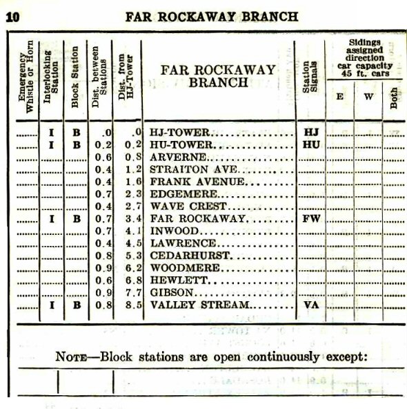
  3. "Far Rockaway Branch Station Listing". Trains Are Fun. June 16, 1929. Retrieved January 23, 2023.
  4. Digital Collections, The New York Public Library. "(cartographic) Queens V. 4, Plate No. 83 [Map bounded by Eastern Ave., Triton Ave., 10th Ave., Bay Ave., Jamaica Bay], (1884 - 1936)". The New York Public Library, Astor, Lenox, and Tilden Foundations. Retrieved January 23, 2023.
  5. "Far Rockaway Branch". Trains Are Fun. Retrieved January 23, 2023.