
Millimeter-wave cloud radars, also denominated cloud radars, are radar systems designed to monitor clouds with operating frequencies between 24 and 110 GHz. Accordingly, their wavelengths range from 1 mm to 1.11 cm, about ten times shorter than those used in conventional S band radars such as NEXRAD.

The Geostationary Earth Radiation Budget (GERB) is an instrument aboard EUMETSAT's Meteosat Second Generation geostationary satellites designed to make accurate measurements of the Earth radiation budget.

The Nimbus satellites were second-generation U.S. robotic spacecraft launched between 1964 and 1978 used for meteorological research and development. The spacecraft were designed to serve as stabilized, Earth-oriented platforms for the testing of advanced systems to sense and collect atmospheric science data. Seven Nimbus spacecraft have been launched into near-polar, Sun-synchronous orbits beginning with Nimbus 1 on August 28, 1964. On board the Nimbus satellites are various instrumentation for imaging, sounding, and other studies in different spectral regions. The Nimbus satellites were launched aboard Thor-Agena rockets and Delta rockets.
Cloud condensation nuclei (CCNs), also known as cloud seeds, are small particles typically 0.2 µm, or one hundredth the size of a cloud droplet. CCNs are a unique subset of aerosols in the atmosphere on which water vapour condenses. This can affect the radiative properties of clouds and the overall atmosphere. Water requires a non-gaseous surface to make the transition from a vapour to a liquid; this process is called condensation.

Atmospheric chemistry is a branch of atmospheric science in which the chemistry of the Earth's atmosphere and that of other planets is studied. It is a multidisciplinary approach of research and draws on environmental chemistry, physics, meteorology, computer modeling, oceanography, geology and volcanology and other disciplines. Research is increasingly connected with other areas of study such as climatology.
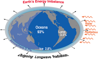
Earth's energy budget accounts for the balance between the energy that Earth receives from the Sun and the energy the Earth loses back into outer space. Smaller energy sources, such as Earth's internal heat, are taken into consideration, but make a tiny contribution compared to solar energy. The energy budget also accounts for how energy moves through the climate system. Because the Sun heats the equatorial tropics more than the polar regions, received solar irradiance is unevenly distributed. As the energy seeks equilibrium across the planet, it drives interactions in Earth's climate system, i.e., Earth's water, ice, atmosphere, rocky crust, and all living things. The result is Earth's climate.

Forrest M. Mims III is an American amateur scientist, magazine columnist, and author of Getting Started in Electronics and Engineer's Mini-Notebook series of instructional books that were originally sold in Radio Shack electronics stores and are still in print. Mims graduated from Texas A&M University in 1966 with a major in government and minors in English and history. He became a commissioned officer in the United States Air Force, served in Vietnam as an Air Force intelligence officer (1967), and a Development Engineer at the Air Force Weapons Laboratory (1968–70).
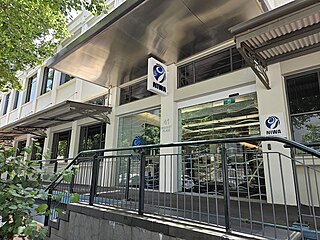
The National Institute of Water and Atmospheric Research or NIWA, is a Crown Research Institute of New Zealand. Established in 1992, NIWA conducts research across a broad range of disciplines in the environmental sciences. It also maintains nationally and, in some cases, internationally important environmental monitoring networks, databases, and collections.

The Max Planck Institute for Chemistry is a non-university research institute under the auspices of the Max Planck Society in Mainz, Germany. It was created as the Kaiser Wilhelm Institute for Chemistry in 1911 in Berlin.
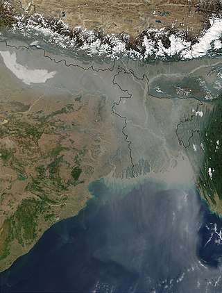
Over the last two centuries many environmental chemical observations have been made from a variety of ground-based, airborne, and orbital platforms and deposited in databases. Many of these databases are publicly available. All of the instruments mentioned in this article give online public access to their data. These observations are critical in developing our understanding of the Earth's atmosphere and issues such as climate change, ozone depletion and air quality. Some of the external links provide repositories of many of these datasets in one place. For example, the Cambridge Atmospheric Chemical Database, is a large database in a uniform ASCII format. Each observation is augmented with the meteorological conditions such as the temperature, potential temperature, geopotential height, and equivalent PV latitude.
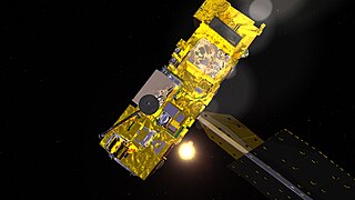
The atmospheric infrared sounder (AIRS) is one of six instruments flying on board NASA's Aqua satellite, launched on May 4, 2002. The instrument is designed to support climate research and improve weather forecasting.

Meteorological instruments, including meteorological sensors, are the equipment used to find the state of the atmosphere at a given time. Each science has its own unique sets of laboratory equipment. Meteorology, however, is a science which does not use much laboratory equipment but relies more on on-site observation and remote sensing equipment. In science, an observation, or observable, is an abstract idea that can be measured and for which data can be taken. Rain was one of the first quantities to be measured historically. Two other accurately measured weather-related variables are wind and humidity. Many attempts had been made prior to the 15th century to construct adequate equipment to measure atmospheric variables.

Chesapeake Light is an offshore lighthouse marking the entrance to the Chesapeake Bay. The structure was first marked with a lightship in the 1930s, and was later replaced by a "Texas Tower" in 1965. The lighthouse was eventually automated and was used for supporting atmospheric measurement sites for NASA and NOAA. Due to deteriorating structural conditions, the lighthouse was deactivated in 2016. At the time, it was the last remaining "Texas Tower" still in use due to obsolescence.
The Global Energy and Water Exchanges Project is an international research project and a core project of the World Climate Research Programme (WCRP).
The Advanced Along Track Scanning Radiometer (AATSR) is one of the Announcement of Opportunity (AO) instruments on board the European Space Agency (ESA)'s Envisat satellite.

EarthCARE is a planned joint European/Japanese satellite, the sixth of ESA's Earth Explorer Programme. The main goal of the mission is the observation and characterization of clouds and aerosols as well as measuring the reflected solar radiation and the infrared radiation emitted from Earth's surface and atmosphere.

SAGE III on ISS is the fourth generation of a series of NASA Earth-observing instruments, known as the Stratospheric Aerosol and Gas Experiment. The first SAGE III instrument was launched on a Russian Meteor-3M satellite. The recently revised SAGE III was mounted to the International Space Station where it uses the unique vantage point of ISS to make long-term measurements of ozone, aerosols, water vapor, and other gases in Earth's atmosphere.

The Amazon Tall Tower Observatory or ATTO is a scientific research facility in the Amazon rainforest of Brazil. This includes a 325-metre-tall (1,066 ft) tower that extends far above the forest canopy and two 80-metre (260 ft) towers that allow researchers to collect samples from the soil surface to above the forest canopy. Additionally, there are climate-controlled containers for laboratory equipment and an office, a base camp and nearby sites for studying vegetation and soil processes. The tall research tower is one metre taller than the Eiffel Tower and is currently the tallest structure in South America. All towers are equipped with a broad range of instruments to measure chemical and physical properties of the atmosphere, such as greenhouse gas concentrations, aerosols and meteorological data.
Mace Head Atmospheric Research Station is located on the West Coast of Ireland in Carna, and is one of the longest running mercury recording stations in the world. The stations location is highly important as it is far away from neighbouring cities to ensure no pollutants interfere with recordings, and its location is also highly important as it is ideal for studying the atmosphere under Northern Hemispheric and European conditions. The station has the dual status of being a World Meteorological Organization (WMO) Global Atmosphere Watch (GMO) station and a European Monitoring and Evaluation Program (EMEP) supersite. Mace Head research and monitor the climate and atmospheric composition, focusing on aerosol-cloud interactions and mercury readings.
Glenn Edmond Shaw is an American scientist specializing in atmospheric physics, especially relating to global climate change and long-range transport of aerosol material. He is Emeritus Professor of Physics and Atmospheric Science at the University of Alaska Fairbanks and a member of the scientific staff of the Geophysical Institute. He conducted research on global atmospheric transport of aerosols and feedback of biogenic aerosols on global climate. He and Kenneth Rahn did research on the sources and climatic effect of Arctic haze. He did pioneering work on the scientific concept of climate homeostasis through the sulfur cycle and atmospheric aerosol.
