Related Research Articles

Atoka County is a county located in the U.S. state of Oklahoma. As of the 2010 census, the population was 14,007. Its county seat is Atoka. The county was formed before statehood from Choctaw Lands, and its name honors a Choctaw Chief named Atoka.

The Lake of the Arbuckles is a reservoir located in southern Oklahoma, 8 miles (13 km) southwest of Sulphur in Murray County. The lake covers 2,350 acres (950 ha) and is a principal water supply reservoir for the city of Ardmore, some 30 mi (48 km) to the southwest. It also supplies water to the cities of Sulphur, Davis, Wynnewood and a large oil refinery near Wynnewood. The lake also provides flood control, fish and wildlife habitat and recreation opportunities.
Lake Overholser is a reservoir within the city limits of Oklahoma City, Oklahoma. Lake Overholser is formed by Overholser Dam on the North Canadian River in Oklahoma County, Oklahoma. The lake is 2.9 miles (4.7 km) west of Bethany. Lake Overholser is named after Ed Overholser who was the 16th Mayor of the City of Oklahoma City.
Lake Stanley Draper is a reservoir in southeast Oklahoma City, United States. It is one of three municipal reservoirs in the city. It was constructed in 1962-1963, and named for the long-time director of the Oklahoma City Chamber of Commerce. Located between Midwest Boulevard and Post Road, near I-240, it receives water by pipeline from Atoka Lake and McGee Creek Reservoir.

Fort Cobb Reservoir is a reservoir located in Caddo County in the U.S. state of Oklahoma. It impounds the waters of Cobb (Pond) Creek and Lake Creek. The lake covers approximately 4,000 acres (16 km²) of water and 45 mi (72 km) of shoreline. Its drainage area is 285 square miles (740 km2). It was constructed in 1958. The towns of Carnegie, Fort Cobb, and Eakly are located nearby.
Konawa Reservoir is a reservoir located in Seminole County, Oklahoma. The lake covers approximately 1,350 acres (5.5 km2) and has a capacity of 23,000 acre feet (28,000,000 m3). It is owned by Oklahoma Gas and Electric (OG&E) Company. and was constructed in 1968-70, to provide cooling for a nearby gas-fired electric power generation plant. It impounds Jumper Creek, about 2 miles (3.2 km) east of the city of Konawa, Oklahoma.
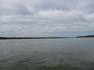
McGee Creek Reservoir is a reservoir in Atoka County, Oklahoma. It impounds the waters of McGee Creek and several smaller streams, including Potapo, Panther, Little Bugaboo, Bear, Blue, Mill, and Crooked creeks, all of which are tributaries of Muddy Boggy River. According to the Bureau of Reclamation (BuRec), the reservoir was designed to extend 14 miles (23 km) up McGee Creek and 9 miles (14 km) up Potapo Creek when the water is at "conservation level.
Lake Thunderbird is a reservoir located in Norman, Oklahoma. The lake was constructed between 1962 and 1965 for the purpose of providing municipal water to the nearby communities of Del City, Midwest City and Norman. It is formed by an earthfill embankment (dam) 7,300 feet (2,200 m) long and up to 144 feet (44 m) high on the Little River. In addition to being a source for drinking water, Lake Thunderbird's secondary uses include numerous recreational activities.

Boggy Depot is a ghost town and Oklahoma State Park that was formerly a significant city in the Indian Territory. It grew as a vibrant and thriving town in present-day Atoka County, Oklahoma, United States and became a major trading center on the Texas Road and the Butterfield Overland Mail route between Missouri and San Francisco. After the American Civil War when the MKT Railroad came through, it bypassed Boggy Depot and the town began a steady decline. It was soon replaced by Atoka as the chief city in the area. By the early 20th century, all that remained of the community was a sort of ghost town.
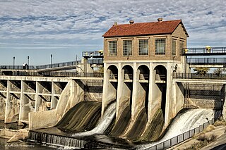
Lake Atoka Reservoir is a reservoir in southeastern Oklahoma, 4 miles (6.4 km) north of Atoka, Oklahoma, county seat of Atoka County, Oklahoma. It was built in 1959 to expand the water supply for Lake Stanley Draper in Oklahoma City and Atoka.

Sardis Lake is a reservoir in Pushmataha and Latimer counties in Oklahoma, USA. It was created about 1980 as the result of a dam constructed on Jackfork Creek, a tributary of the Kiamichi River, by the United States Corps of Engineers under contract to the state. It is named for the now-defunct town of Sardis, Oklahoma, which had to be abandoned before the area was submerged in the flooding of the lake.. The lake is located approximately 5 miles (8.0 km) north of Clayton. It is part of the Kiamichi Basin.

Black Mesa State Park is an Oklahoma state park in Cimarron County, near the western border of the Oklahoma panhandle and New Mexico. The park is located about 15 miles (24 km) away from its namesake, Black Mesa, the highest point in Oklahoma. The mesa was named for the layer of black lava rock that coats it.
Muddy Boggy Creek, also known as the Muddy Boggy River, is a 175-mile-long (282 km) river in south central Oklahoma. The stream headwaters arise just east of Ada in Pontotoc County. It is a major tributary of the Red River in south central Oklahoma. Clear Boggy Creek is a major tributary which enters the Muddy Boggy at a location known as River Mile 24 in Choctaw County. The river is inhabited by over one hundred species of fish.
Boomer Lake is located in the city of Stillwater, Oklahoma, United States, and was completed in 1925. The lake, as an artificial reservoir created by damming Stillwater Creek, serves several purposes such as cooling the local power plant and providing entertainment and recreation. Boomer Lake has a surface area of 251 acres (1,020,000 m2), watershed area of 8,954 acres (36,240,000 m2), shoreline length of 8.6 miles (13.8 km), shoreline development ratio of 4.17, and mean depth of 9.7 feet (3.0 m). The lake was designed to contain 3,600 acre feet (4,400,000 m3) in 1932, but in 2010 the capacity was reportedly only 1,484 acre feet (1,830,000 m3).
Raymond Gary Lake is a reservoir in southeastern Oklahoma, United States, one mile east of the town of Fort Towson in Choctaw County. It was constructed on Gates Creek in 1956 by the Oklahoma Department of Wildlife Conservation.
Foss Reservoir, also known as Foss Lake, is in Custer County, Oklahoma on the Washita River, about 15 miles (24 km) west of Clinton, Oklahoma. The reservoir was constructed during 1958–1961 by the U. S. Bureau of Reclamation. The project was known originally as the Washita Basin Project. The lake and dam were named for the community of Foss, Oklahoma, about 6 miles (9.7 km) south of the site. The primary purposes are to regulate flow of the river and to provide water for the cities of Bessie, Clinton, Cordell and Hobart. It is western Oklahoma's largest lake and lies entirely within Foss State Park.
Fuqua Lake is a reservoir located in Stephens County, Oklahoma, about 21 miles (34 km) northeast of the city of Duncan on State Highway 29. Constructed in 1962, it is the largest of four reservoirs that comprise the public water supply for Duncan.
Holdenville Lake is a reservoir in Hughes County, Oklahoma. Owned and operated by the City of Holdenville, Oklahoma, it supplies most of the drinking water for Hughes County. It is just 3.5 miles (5.6 km) south of Holdenville and a 1.5 hour drive from Oklahoma City.
Chickasha Lake is a man-made reservoir in the central part of the state of Oklahoma. Located on Spring Creek in Caddo County, Oklahoma, it was completed in 1958. The main purposes were supplying water and for recreation. The lake is reported to be 9 miles (14 km) west of Chickasha, and is operated by that city.
References
- ↑ "Archived copy". Archived from the original on 2015-01-12. Retrieved 2015-01-24.CS1 maint: archived copy as title (link)
- 1 2 Oklahoma Water Resource Board
- ↑ "Atoka Reservoir." Top Reservoirs in Atoka County. Accessed December 27, 2018.
- ↑ "Atoka Lake, Oklahoma." OutdoorsOK. Accessed August 28, 2015.
- ↑ "Oklahoma Lakes and Rivers." Leisure and Sports Review (LASR.com) Accessed August 28, 2015.
- ↑ Krehbiel-Burton, Lenzy. "Tribes sue over water rights to lake." Native American Times. August 22, 2011. August 28, 2015.