Surat is a city in the western Indian state of Gujarat. The word Surat directly translates to face in Urdu, Gujarati and Hindi. Located on the banks of the river Tapti near its confluence with the Arabian Sea, it used to be a large seaport. It is now the commercial and economic centre of South Gujarat, and one of the largest urban areas of western India. It has well-established diamond and textile industry, and is a major supply centre for apparels and accessories. About 90% of the world's diamonds are cut and polished in Surat. It is the second largest city in Gujarat after Ahmedabad and the eighth largest city by population and ninth largest urban agglomeration in India. It is the administrative capital of the Surat district.
Valsad, historically known as Bulsar, is a city and a municipality in Valsad district of the Indian state of Gujarat. It is the district headquarters of Valsad district. Valsad is located south of Navsari and shares border with Maharashtra and the union territories of Dadra and Nagar Haveli and Daman and Diu in the south.

Navsari is an administrative district in the state of Gujarat in India, with its headquarters at the city of Navsari. The district covers an area of 2,211 square kilometres and was formed in 1997 after Valsad district was split into Valsad and Navsari districts. It is the largest producer of chikoos in India.

Vapi, is a city and Municipal Corporation in Valsad district in the state of Gujarat, India. It is situated near the banks of the Daman Ganga River, around 28 km south of the district headquarters in the city of Valsad, and it is surrounded by the Union Territory of Dadra and Nagar Haveli and Daman and Diu. The town originally belonged to the Kshatriya Jagirdar family Palande during The Great Maratha Empire. After independence from the British Crown, the Jagirdar system was abolished by the Indian government in 1951 and the community of Anavil Brahmin who formerly acted as tax farmers during the era of the Maratha Empire received the land. It is believed that the city got its name from the old small stepwell which was built by Maratha and is situated near the Balitha area.The meaning of vapi (वापी) in sanskrit is a water reservoir or a water storage body.

Abu Road is a city and sub-district in Sirohi district of Rajasthan state in western India, lies on the bank of West Banas River. It is the tehsil and sub-district headquarters and the largest city in Sirohi District in terms of area and population. Its railway station is an important stop on the main Indian Railways line between New Delhi and Ahmedabad and registers an impressive growth in passenger traffic and revenue generation for North Western Railway zone. The popular hill station, Mount Abu is 27 km up the hill from Abu Road.

Valsad district is one of the 33 districts in the Western Indian state of Gujarat. It is bound by Navsari district to the north, Nashik district of Maharashtra state to the east, and Dadra and Nagar Haveli district of the Dadra and Nagar Haveli and Daman and Diu (DNHDD) union territory and the Palghar district of Maharashtra to the south. The Arabian Sea lies west of the district. The coastal Damaon enclave of DNHDD is bounded by Valsad district on the north, east, and south. The district's administrative capital is Valsad. The district's largest city is Vapi.

Veraval is a city and the headquarters of Gir Somnath district in the Indian state of Gujarat. Somnath temple, a place of pilgrimage due to its importance as Jyotirlinga site dedicated to Hindu deity Shiva, is located here. It is also known for the hub of fishing industries in India.
Bilimora is a city situated on the banks of the river Ambika, in Gandevi taluka & Navsari district of Gujarat state, in India. The city comes under the purview of the Surat Metropolitan Region. The city is roughly 70 kilometres (43 mi) south of the city of Surat and is the southernmost point of the Surat Metropolitan Region and the Metropolis of Surat. It is linked to Surat by SH 6 and SH 88.
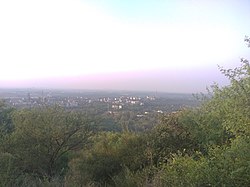
Magod is a small village in South Gujarat in the Valsad district. It has been there for a period of approximately 350 years. It is a fertile area which is heavily used for agriculture.
Nizar (Nijhar) is one of the 7 tehsils in Tapi district in the Indian state of Gujarat. Nizar was separated from Surat district in 2007 while Tapi district was formed. Nizar is located in South Gujarat, about 172 km from Surat bordering Nandurbar district of Maharashtra. The official language is Gujarati.

Atul Ltd is an integrated chemical company founded by Kasturbhai Lalbhai on September 5, 1947 in India. The company manufactures 900 products and 400 formulations and owns 140 retail brands. It serves 4,000 customers belonging to 30 diverse industries and has established subsidiary companies in the US, the UK, the UAE, China and Brazil to serve its customers.

The Ahmedabad–Mumbai main line or the Mumbai–Ahmedabad main line is a railway route on the Western Railway section of Indian Railways. It is one of the busiest railway routes of the Indian Railways and is fully electrified. The Western line of the Mumbai Suburban Railway operates on the southern part of this route.

Surat Diamond Bourse (SDB) is a diamond trade centre located in DREAM City, Surat, Gujarat, India, designed by the architecture firm Morphogenesis. It is the world's largest diamond trading hub with a floor space of 660,000 square metres (7,100,000 sq ft), as well as the world's largest office building.The current Chairman is Govind Dholakia and CEO of Surat Diamond Bourse is Mahesh Gadhavi.
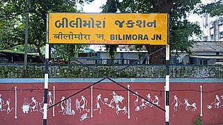
Bilimora Junction railway station is a small railway station in Navsari district, Gujarat, India. Its code is BIM. It serves the city of Bilimora. The station consists of five platforms. The platforms are not well sheltered. It lacks many facilities including water and sanitation. Passenger, Express and Superfast trains halt here.
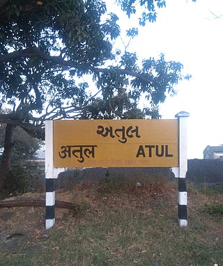
Atul railway station is a small railway station on the Western Railway network in the state of Gujarat, India. Atul is 'E' category railway station of Western Railway. Atul railway station is 7 km from Valsad railway station. Adjacent to Atul railway station is a coal yard. Passenger and MEMU trains halt here.
Mahemadavad Kheda Road railway station is a railway station on the Western Railway network in the state of Gujarat, India. This Station Connects to Kheda City and Mahemdavad Town. Mhemadavad Kheda Road railway station is 18km from Nadiad railway station. Passenger, MEMU, and a few Express/Superfast trains halt at Mahemadavad Kheda Road railway station. This railway station's nearest city is Kheda.
The 19417 / 19418 Borivali-Ahmedabad Express is an express train of the Indian Railways connecting Borivali in Maharashtra and Ahmedabad Junction of Gujarat. It is currently being operated with 19417/19418 train numbers on a daily basis.
Ancheli railway station is a small railway station on the Western Railway network in the state of Gujarat, India. Ancheli railway station is 12 km away from Navsari railway station. Passenger and MEMU trains halt here.
Bagwada is a small town station on the Western Railway network in the state of Gujarat, India. Bagwada railway station is 20 km away from Valsad railway station. This village was developed by Chhatrapati Shivaji Maharaj.This village is surrounded with old temples and has a small fort on the hill top of Arjungadh