
View to north from historic U.S. Route 66−(Arizona Route 66)
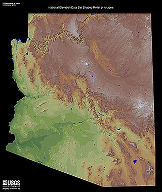
Aubrey Cliffs are a series of cliff escarpments located in Coconino County, in northwestern Arizona.
Aubrey Cliffs are a series of cliff escarpments located in Coconino County, in northwestern Arizona.
The Toroweap Fault, west of Aubrey Valley in the south, and of Prospect Valley in the northwest, formed the Aubrey Cliffs. The cliffs form part of the southwest perimeter of the Coconino Plateau. The Toroweap Fault separates from the Hurricane Fault-(Hurricane Cliffs), at the Colorado River, in the western Grand Canyon. Both faults continue northeast, and northwest into southern Utah.
The Aubrey Cliffs begin near Route 66 about five miles west of Seligman and run generally north to the Colorado River in the Grand Canyon (coordinates ranging from 35.35, -112.95 to 36.19, -113.02). [1] The most prominent section is southern half, which overlooks the Aubrey Valley to the west and rises approximately 1,000 feet (300 m) above the valley floor to an elevation of about 6,300 feet (1,900 m). It is located on the Big Boquillas Ranch, a checkerboard area of state trust land and fee land owned by the Navajo Nation.
The northern half overlooks Prospect Valley and is located on the Hualapai Indian Reservation.
The southern cliffs are the site of a proposed 85 megawatt wind farm being developed by the Navajo Nation. [2] [3]

The Hualapai is a federally recognized Native American tribe in Arizona with about 2300 enrolled members. Approximately 1353 enrolled members reside on the Hualapai Reservation, which spans over three counties in Northern Arizona.

Horseshoe Bend is a horseshoe-shaped incised meander of the Colorado River located near the town of Page, Arizona, United States. It is also referred to as the "east rim of the Grand Canyon."
Coconino Sandstone is a geologic formation named after its exposure in Coconino County, Arizona. This formation spreads across the Colorado Plateau province of the United States, including northern Arizona, northwest Colorado, Nevada, and Utah.

Oak Creek Canyon is a river gorge located in northern Arizona between the cities of Flagstaff and Sedona. The canyon is often described as a smaller cousin of the Grand Canyon because of its scenic beauty. State Route 89A enters the canyon on its north end via a series of hairpin turns before traversing the bottom of the canyon for about 13 miles (21 km) until the highway enters the town of Sedona.

Vulcan's Throne is a cinder cone volcano and a prominent landmark on the North Rim of the Grand Canyon in Arizona, United States. The volcano is adjacent the Colorado River, as it is the source material for Lava Falls and Lava Falls Rapids one of the largest rapids of the Colorado. Vulcan's Throne, about a mile (1.7 km) west of Toroweap overlook, is part of the Uinkaret volcanic field. The journals of traveler George Corning Fraser record a trip to the summit of Vulcan's Throne in 1914. At the time, the surrounding area was used for sheep grazing, and a small reservoir had been constructed at the base of the volcano. Fraser wrote that
Vulcan's Throne is a pure cinder cone covered with scoriae, cinders, clinkers and peperino lying loose on the surface, with a slope, as near as I could measure, from 28° to 31°. A little sage, many cacti and perhaps some other similar low plants grow on it, but otherwise nothing. Climbing it was like ascending a sand-dune. Every step forward involved slipping half way back and boots were soon filled with painful bits of stone.

The Tuckup Trail is a 100-mile-long (160 km) hiking trail on the North Rim of the Grand Canyon, in Grand Canyon National Park, located in the U.S. state of Arizona.
The Chino Valley of Arizona is a large, 70-mi (113 km) long valley, centered on Seligman, Arizona in northwest Yavapai County and southwest Coconino County. The valley is located at the southwest of the Coconino Plateau and lies in the extreme northwest of Arizona's transition zone.

The Hurricane Cliffs of southwest Utah and northwest Arizona are a red, limestone geographic feature, sets of cliffs along the western, eroded edge of the Kaibab Limestone; the cliffs are about 135-mi (217 km) long, with the south end terminus just north of the Grand Canyon. The cliffs are associated with the Hurricane Fault.
The Defiance Plateau, part of the geologic Defiance Uplift, is an approximately 75-mile (121 km) long, mostly north-trending plateau of Apache County, Arizona, with its east and southeast perimeter, as parts of San Juan and McKinley Counties, New Mexico.

Aubrey Valley is a 35-mile (56 km) long valley located in southwest Coconino County, Arizona with the northwest border of Yavapai County. The valley is located at the southwest border of the Aubrey Cliffs; to the west and southwest, the Yampai Divide and the Seventyfour Plains form flatlands between four bordering mountain ranges at the northwest terminus of the Arizona transition zone.

Temple Butte, in the Grand Canyon, Arizona, US is a prominence below the East Rim. The butte lies on the west bank of the south-flowing Colorado River. The outfall from the Little Colorado River, draining from the Painted Desert to the east and southeast, is about two miles upstream.

The Middle Permian Toroweap Formation is a thin, darker geologic unit, between the brighter colored units of the Kaibab Limestone above, and Coconino Sandstone below. It is a prominent unit in Grand Canyon, Arizona, USA, found through sections of the South Rim, Grand Canyon, and the North Rim, of the Kaibab Plateau; also the Kaibab's southeast extension to Cape Royal, the Walhalla Plateau. The Colorado River of the Grand Canyon makes its excursion from due-south to due-west around the Walhalla Plateau, as it enters the east end of the Grand Canyon's interior, Granite Gorge. The formation is also found in southeast Utah.

The Toroweap Fault of northwest Arizona and southwest Utah is part of a fault system of the west Grand Canyon region, Arizona, US; also the west perimeter regions of the Coconino and Colorado Plateaus. The Hurricane Fault originates at the Toroweap Fault, in the region of the Colorado River, and strikes as the westerly depression of the Toroweap Fault. The Toroweap strikes northerly from the Colorado at the east of Toroweap Valley, and enters south Utah; from the Colorado River, the Hurricane Fault strikes north-northwest along the west flank of the small, regional Uinkaret Mountains, the west border of Toroweap Valley. The Hurricane Fault, and the Hurricane Cliffs strike into southwest Utah as part of the west, and southwest perimeter of the Colorado Plateau. The Hurricane Cliffs are made of Kaibab Limestone, an erosion resistant, cliff-forming rock unit.

The Lower Permian Esplanade Sandstone is a cliff-forming, resistant sandstone, dark red, geologic unit found in the Grand Canyon. The rock unit forms a resistant shelf in the west Grand Canyon, south side of the Colorado River, at the east of the Toroweap Fault, down-dropped to west, southeast of Toroweap Overlook, and west of Havasupai. The red, sandstone shelf, The Esplanade is about 20-mi long. At Toroweap Overlook region, Toroweap Valley with Vulcan's Throne, Uinkaret volcanic field, the resistant Esplanade Sandstone is described in access routes exploring the Toroweap Lake area.

The White Rim Sandstone is a sandstone geologic formation located in southeastern Utah. It is the last member of the Permian Cutler Group, and overlies the major Organ Rock Formation and Cedar Mesa Sandstone; and again overlies thinner units of the Elephant Canyon and Halgaito Formations.
The Peacock Mountains are a small, 26 mi (42 km) long mountain range in northwest Arizona, US. The range is a narrow sub-range, and an extension north, at the northeast of the Hualapai Mountains massif, which lies to the southwest. The range is defined by the Hualapai Valley to the northwest, and north and south-flowing washes on its east border, associated with faults and cliffs; the Cottonwood Cliffs are due east, and are connected to the Aquarius Cliffs southward at the west perimeter of the Aquarius Mountains; the cliffs are a result of the Aquarius Fault, which is an extension southward from the Grand Wash Cliffs and Grand Wash Fault which crosses the Colorado River at Lake Mead, and the west perimeter of the Grand Canyon/Colorado Plateau.

Toroweap Overlook is a viewpoint within the Grand Canyon National Park in Arizona, United States. It is located in a remote area on the North Rim of the Grand Canyon, 55 miles (89 km) west of the North Rim Headquarters. The overlook is the only viewpoint in the National Park from where the Colorado River can be seen vertically below. The overlook stands 3,000 feet (910 m) above the river.

Cape Royal is a 7,880+-cliff-elevation summit located in the eastern Grand Canyon, Coconino County of northern Arizona, United States. It is the southernmost viewpoint of the North Rim, viewing from north-northeast, south, west, southwest. Its next viewpoint northwest is Honan Point, with Thor Temple directly below. Directly east-northeast is the major viewing point of Cape Final, which gives views almost directly north. The 1/2 mile Cape Royal Trail starts at the parking lot and ends at the overlook at Cape Royal.
From Cape Royal, directly southeast can be seen the massif and highpoint of Freya Castle, and southeasterly is massive Wotans Throne, which is a surviving section of the North Rim, with a Ponderosa Pine, forested, flat prominence. The cliffs of Cape Royal are composed of Kaibab Limestone, on erodible Toroweap Formation, upon white cliffs of Coconino Sandstone. The watershed drainage from Cape Royal, overlooks the Unkar Creek and Canyon to the south into the Colorado River, about 6 miles distant.

Castor is a 6,221-foot-elevation (1,896-meter) summit located in the Grand Canyon, in Coconino County of northern Arizona, United States. It is situated 11 miles west-northwest of Grand Canyon Village, and less than one mile north of Piute Point. Pollux Temple is one mile southeast, and Geikie Peak is three miles to the east. Topographic relief is significant as Castor Temple rises over 3,800 feet above the Colorado River in two miles.

Cocopa Point is a 6,627 foot (2,020 m)-cliff-elevation Point located in the central,, Grand Canyon, Coconino County of northern Arizona, United States. Cocopa Point is 1.1 miles from its closest highest scenic viewpoint, Yuma Point (6,654 ft), located east at Eremita Mesa, at the northeast, overlooking Central Hermit Canyon.
Cocopa Point is in a region of points, at the headwaters of canyons, and landforms below the South Rim. Mimbreno Point lies ~1.7 miles west, and Hermit Canyon and Pima Point, at the west-terminus of West Rim Drive, are about 1.5 mi and 2.0 miles due-east. Cocopa Point is at the northwest of Eremita Mesa; Yuma Point is at the northeast; the mesa lies between Hermit Canyon, east, and Upper Boucher Canyon, west. Cocopa Point is a sheer-walled cliff, sitting at the northwest headwaters of short, Travertine Canyon. At the west of Lower Travertine Canyon, adjacent the Colorado River, sits Whites Butte, about 1.2 miles distant from Cocopa Point.