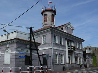
Dąbie is a town on the Ner River in central Poland with 2200 inhabitants, situated in Koło County in Greater Poland Voivodeship.

Wilczeniec Fabiański is a village in the administrative district of Gmina Fabianki, within Włocławek County, Kuyavian-Pomeranian Voivodeship, in north-central Poland. It lies approximately 3 kilometres (2 mi) north-west of Fabianki, 10 km (6 mi) north of Włocławek, and 46 km (29 mi) south-east of Toruń.
Łukowisko Ukrainian: Луковисько, Lukovys'ko) is a village in the administrative district of Gmina Międzyrzec Podlaski, within Biała Podlaska County, Lublin Voivodeship, in eastern Poland. It lies approximately 12 kilometres (7 mi) north of Międzyrzec Podlaski, 27 km (17 mi) west of Biała Podlaska, and 94 km (58 mi) north of the regional capital Lublin.
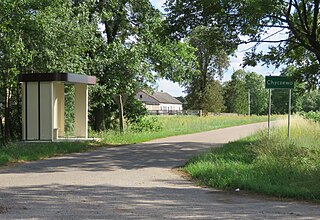
Chyczewo is a village in the administrative district of Gmina Raciąż, within Płońsk County, Masovian Voivodeship, in east-central Poland. It lies approximately 6 kilometres (4 mi) south-west of Raciąż, 24 km (15 mi) north-west of Płońsk, and 85 km (53 mi) north-west of Warsaw.
Długie is a village in the administrative district of Gmina Chodów, within Koło County, Greater Poland Voivodeship, in west-central Poland. It lies approximately 8 kilometres (5 mi) north-west of Chodów, 25 km (16 mi) north-east of Koło, and 139 km (86 mi) east of the regional capital Poznań.
Baranowiec is a village in the administrative district of Gmina Dąbie, within Koło County, Greater Poland Voivodeship, in west-central Poland. It lies approximately 5 kilometres (3 mi) north-east of Dąbie, 19 km (12 mi) south-east of Koło, and 137 km (85 mi) east of the regional capital Poznań.

Chełmno, often known by its full name Chełmno nad Nerem is a village in the administrative district of Gmina Dąbie, within Koło County, Greater Poland Voivodeship, in west-central Poland. It lies approximately 19 km (12 mi) south-east of Koło and 135 km (84 mi) east of the regional capital Poznań. The village has a population of 350. It is the location of the Chełmno Extermination Camp Museum (pl) founded in 1994.
Chruścin is a village in the administrative district of Gmina Dąbie, within Koło County, Greater Poland Voivodeship, in west-central Poland. It lies approximately 5 kilometres (3 mi) west of Dąbie, 16 km (10 mi) south-east of Koło, and 131 km (81 mi) east of the regional capital Poznań.
Cichmiana is a village in the administrative district of Gmina Dąbie, within Koło County, Greater Poland Voivodeship, in west-central Poland. It lies approximately 3 kilometres (2 mi) west of Dąbie, 17 km (11 mi) south-east of Koło, and 133 km (83 mi) east of the regional capital Poznań.
Grabina Wielka is a village in the administrative district of Gmina Dąbie, within Koło County, Greater Poland Voivodeship, in west-central Poland. It lies approximately 5 kilometres (3 mi) north-west of Dąbie, 14 km (9 mi) south-east of Koło, and 132 km (82 mi) east of the regional capital Poznań.
Karszew is a village in the administrative district of Gmina Dąbie, within Koło County, Greater Poland Voivodeship, in west-central Poland. It lies approximately 5 kilometres (3 mi) east of Dąbie, 21 km (13 mi) south-east of Koło, and 139 km (86 mi) east of the regional capital Poznań.
Kupinin is a village in the administrative district of Gmina Dąbie, within Koło County, Greater Poland Voivodeship, in west-central Poland. It lies approximately 4 kilometres (2 mi) north-east of Dąbie, 20 km (12 mi) south-east of Koło, and 137 km (85 mi) east of the regional capital Poznań.
Lutomirów is a village in the administrative district of Gmina Dąbie, within Koło County, Greater Poland Voivodeship, in west-central Poland. It lies approximately 8 kilometres (5 mi) west of Dąbie, 13 km (8 mi) south-east of Koło, and 128 km (80 mi) east of the regional capital Poznań.
Rzuchów is a village in the administrative district of Gmina Dąbie, within Koło County, Greater Poland Voivodeship, in west-central Poland. It lies approximately 9 kilometres (6 mi) north-west of Dąbie, 11 km (7 mi) south-east of Koło, and 127 km (79 mi) east of the regional capital Poznań.
Sobótka is a village in the administrative district of Gmina Dąbie, within Koło County, Greater Poland Voivodeship, in west-central Poland. It lies approximately 4 kilometres (2 mi) north-west of Dąbie, 16 km (10 mi) south-east of Koło, and 132 km (82 mi) east of the regional capital Poznań.
Wiesiołów is a village in the administrative district of Gmina Dąbie, within Koło County, Greater Poland Voivodeship, in west-central Poland. It lies approximately 3 kilometres (2 mi) north-east of Dąbie, 19 km (12 mi) south-east of Koło, and 136 km (85 mi) east of the regional capital Poznań.
Cząstków is a village in the administrative district of Gmina Kłodawa, within Koło County, Greater Poland Voivodeship, in west-central Poland. It lies approximately 4 kilometres (2 mi) north-west of Kłodawa, 18 km (11 mi) north-east of Koło, and 134 km (83 mi) east of the regional capital Poznań.

Powiercie is a village in the administrative district of Gmina Koło, within Koło County, Greater Poland Voivodeship, in west-central Poland. It lies approximately 5 kilometres (3 mi) east of Koło and 124 km (77 mi) east of the regional capital Poznań.
Nowy Zagór is a village in the administrative district of Gmina Dąbie, within Krosno Odrzańskie County, Lubusz Voivodeship, in western Poland. It lies approximately 5 kilometres (3 mi) west of Dąbie, 4 km (2 mi) south of Krosno Odrzańskie, and 30 km (19 mi) west of Zielona Góra.


