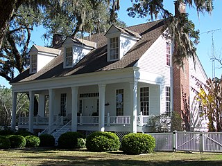
Capps is an unincorporated community in Jefferson County, Florida, United States. It is located at the intersection of U.S. Routes 19 and 27. During the 1940s and 1950s, Capps was the headquarters of an agribusiness known as Tungston Plantation, owned by Everett P. Larsh, an industrialist from Dayton, Ohio, and managed by L. H. Crampton. Tungston plantation comprised a total of approximately 16,000 acres, of which about 8,000 acres was planted in tung trees. Each year, the tung nut was harvested and brought to the mill at Capps, and its contents processed into tung oil for use in paints, varnishes and other products. During those years, Tungston Plantation constituted the largest tung operation in the U.S. under single ownership.

Sevazhayr, is a village in the Vayots Dzor Province of Armenia. It belongs to the Yeghegis Municipality.

Varna is a village in the Ismailli Rayon of Azerbaijan.

Rosanów is a village in the administrative district of Gmina Zgierz, within Zgierz County, Łódź Voivodeship, in central Poland. It lies approximately 8 kilometres (5 mi) north of Zgierz and 16 km (10 mi) north of the regional capital Łódź.
Grabno is a village in the administrative district of Gmina Ustka, within Słupsk County, Pomeranian Voivodeship, in northern Poland. It lies approximately 5 kilometres (3 mi) south-east of Ustka, 13 km (8 mi) north-west of Słupsk, and 114 km (71 mi) west of the regional capital Gdańsk.
Maciejewo is a village in the administrative district of Gmina Braniewo, within Braniewo County, Warmian-Masurian Voivodeship, in northern Poland, close to the border with the Kaliningrad Oblast of Russia. It lies approximately 6 kilometres (4 mi) south-east of Braniewo and 75 km (47 mi) north-west of the regional capital Olsztyn.
Ghilassa is a town and commune in Bordj Bou Arréridj Province, Algeria. According to the 1998 census it has a population of 10,959.
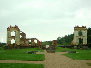
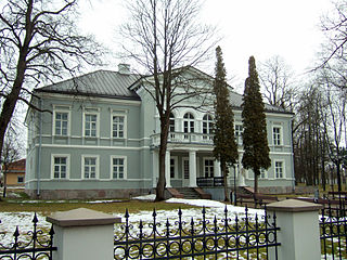
Aštrioji Kirsna Manor is a former residential manor in Aštrioji Kirsna village, Lazdijai district, Alytus County, Lithuania.
Bulakavas Manor is a former residential manor in Bulotiškė village, Lazdijai District Municipality, Lithuania.
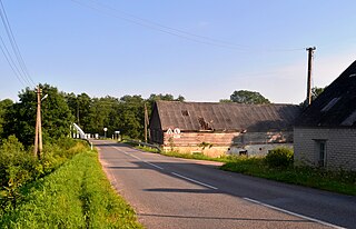
Čiobiškis Manor is a former residential manor on the confluence of Musė and Neris rivers, the southern part of Čiobiškis. Manor complex consists of manor, farm laborers and stable. Manor is currently for sale for 720 thousand litas.
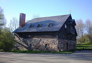
Leipalingis Manor was a residential manor in Leipalingis, Lithuania. Only oficina remained until nowadays.
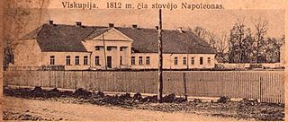
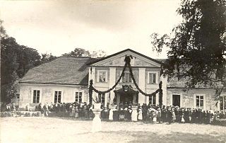
Merkinė Manor was a residential manor in Merkinė village, Šalčininkai District Municipality, Lithuania. It was the location of the self-proclaimed Paulava Republic, established by Paweł Ksawery Brzostowski in 1769.
Veisiejai Manor was a residential manor in Veisiejai, Lazdijai district. The manor has one of the oldest parks in Lithuania, however only one pavilion remained until nowadays, which was reconstructed.
Vilkaviškis Manor is a former residential manor in Vilkaviškis, Vilkaviškis District Municipality, Lithuania. Currently it is partially reconstructed.
Antanavas Manor is a former residential manor in Antanavas village, Kazlų Rūda municipality.
Baltoji Vokė Manor is a former Tyszkiewicz family residential manor in Baltoji Vokė village of the Vilnius district, in Lithuania.
Bartkūniškis Manor is a former residential manor in Barkūniškis village, Kėdainiai district.

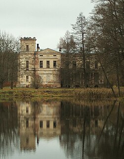
Zypliai Manor is a former Tyszkiewicz residential manor in Tubeliai village, Šakiai District Municipality, Lithuania.
Šalčininkai Manor is a former Vagneriai residential manor in Šalčininkai city, Šalčininkai District Municipality, Lithuania.
Freda is part of the city of Kaunas on the left bank of the Nemunas, east of Aleksotas. Divided into High and Low. It occupies an area of 416 hectares. The main street is European Prospect. Čiurlionis Bridge connects with Kaunas center.


