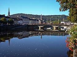
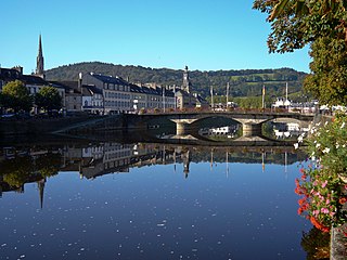
Le Mans is a city in Northwestern France on the Sarthe River where it meets the Huisne. Traditionally the capital of the province of Maine, it is now the capital of the Sarthe department and the seat of the Roman Catholic diocese of Le Mans. Le Mans is a part of the Pays de la Loire region.

Brittany is a peninsula, historical country and cultural area in the north-west of modern France, covering the western part of what was known as Armorica during the period of Roman occupation. It became an independent kingdom and then a duchy before being united with the Kingdom of France in 1532 as a province governed as a separate nation under the crown. Brittany is the traditional homeland of the Breton people and is one of the six Celtic nations, retaining a distinct cultural identity that reflects its history.

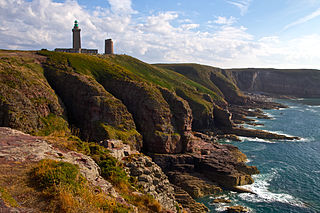
Brest is a port city in the Finistère department, Brittany. Located in a sheltered bay not far from the western tip of a peninsula and the western extremity of metropolitan France, Brest is an important harbour and the second largest French military port after Toulon. The city is located on the western edge of continental France. With 139,456 inhabitants (2020), Brest forms Western Brittany's largest metropolitan area, ranking third behind only Nantes and Rennes in the whole of historic Brittany, and the 25th most populous city in France (2019); moreover, Brest provides services to the one million inhabitants of Western Brittany. Although Brest is by far the largest city in Finistère, the préfecture of the department is in the much smaller town of Quimper.
Brittany is the westernmost region of Metropolitan France. It covers about four fifths of the territory of the historic province of Brittany. It is one of two regions in Metropolitan France that do not contain any landlocked departments, the other being Corsica.

Nantes is a city in the Loire-Atlantique department of France on the Loire, 50 km (31 mi) from the Atlantic coast. The city is the sixth largest in France, with a population of 320,732 in Nantes proper and a metropolitan area of nearly 1 million inhabitants (2020). With Saint-Nazaire, a seaport on the Loire estuary, Nantes forms one of the main north-western French metropolitan agglomerations.
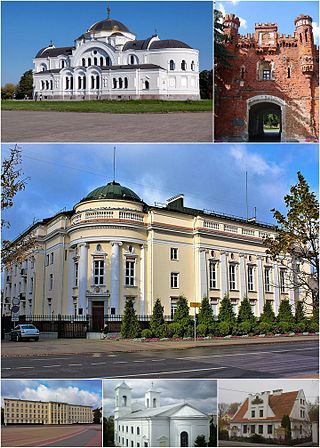
Brest, formerly Brest-Litovsk and Brest-on-the-Bug, Berestia, is a city in Belarus at the border with Poland opposite the Polish town of Terespol, where the Bug and Mukhavets rivers meet, making it a border town. It serves as the administrative center of Brest Region and Brest District, though it is administratively separated from the district. As of 2024, it has a population of 344,470.

The Vilaine is a river in Brittany, in the west of France. The river's source is in the Mayenne département (53), and it flows out into the Atlantic Ocean at Pénestin in the Morbihan département (56). It is 218 km long.

Pontivy is a commune in the Morbihan department in Brittany in north-western France. It lies at the confluence of the river Blavet and the Canal de Nantes à Brest. Inhabitants of Pontivy are called Pontivyens in French.
Châteaulin is a commune in the Finistère department and administrative region of Brittany in north-western France. It is a sub-prefecture of the department.

The Blavet river flows from central Brittany and enters the Atlantic Ocean on the south coast near Lorient. It is 148.9 km (92.5 mi) long. The river is canalised for most of its length, forming one of the links in the Brittany canal system. It connects with the Canal de Nantes à Brest at Pontivy and runs to Hennebont, a distance of 60 km. From the last lock at Polvern, the river is tidal and considered as a maritime waterway, giving access to the seaport of Lorient and the Atlantic Ocean. It became more important when the western half of that system was cut off by the construction of the Guerlédan dam and hydropower plant. Today, boats coming from Nantes via Redon have to take the Canal du Blavet in order to reach the ocean near Lorient.

The Nantes–Brest canal is a French canal which links the two seaports of Nantes and Brest through inland Brittany. It was built in the early 19th century, and its total length as built was 385 km with 238 locks.
Saint-Goazec in commune in the Finistère department of Brittany in northwestern France.

Malestroit is a commune in the Morbihan department of Brittany in north-western France. The town is on the river Oust and part of the Nantes-Brest canal. It has several half-timbered houses.

Saint-Gravé is a commune in the Morbihan department of Brittany in northwestern France.

Châteauneuf-du-Faou is a commune in the Finistère department of Brittany in north-western France.

Rosnoën is a commune in the Finistère department of Brittany in north-western France.

Spézet is a commune in the Finistère department of Brittany in north-western France.

The roadstead of Brest is a roadstead or bay located in the Finistère department in Brittany in northwestern France. The surface area is about 180 km². The port of Brest and one of the two French naval bases, Brest Arsenal, are located on its northern edge. It is linked to the Atlantic Ocean by the Goulet de Brest, a strait about 1.8 km wide. Three main rivers drain into the roadstead: the Penfeld, the Élorn and the Aulne.

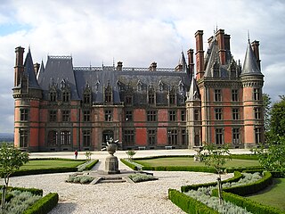
The Château de Trévarez is a stately home in the commune of Saint-Goazec in Finistère, in Brittany, France.
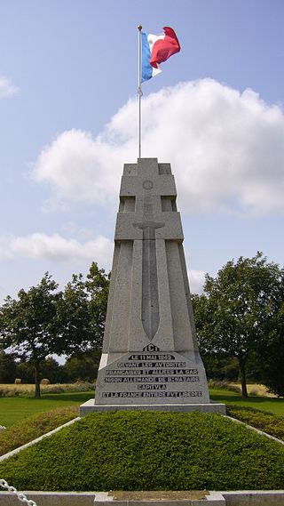
The Saint-Nazaire Pocket was an Atlantic pocket that existed from August 1944 until 11 May 1945 and was formed by the withdrawal of German troops from Loire-Inférieure during the liberation of the department by the allied forces. It was centred around the port and the submarine base of Saint-Nazaire and extended to the east as far as Saint-Omer-de-Blain and from La Roche-Bernard in the north to Pornic in the south.