
Osmanabad District, officially known as Dharashiv District, is an administrative district in the Marathwada region in the Indian state of Maharashtra. The district headquarter is located at Osmanabad. The District of Osmanabad derives its name from the last ruler of Hyderabad, the 7th Nizam, Mir Osman Ali Khan, of which the region was a part till 1947. This region was earlier part of The Hyderabad State until Independence.This primarily rural district occupies an area of 7,569 km2 (2,922 sq mi) of which 241.4 km2 (93.2 sq mi) is urban and has a population of 1,657,576 of which 16.96% were urban.
Nanded district is a district of Maharashtra state in central India. The city of Nanded is the district headquarters.

Latur district is a district in Maharashtra state of India. Latur city is the district headquarters and is the 16th largest city in the state of Maharashtra. The district is primarily agricultural. Urban population comprises 25.47% of the total population.
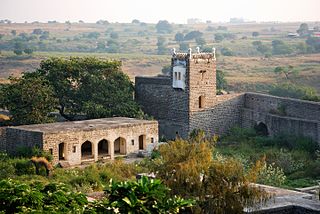
Udgir is the second largest city in Latur district and Municipal Corporation of the Indian state of Maharashtra. It is located in the Marathwada division of the state. The city is located very close to the borders of Karnataka and Telangana states. Udgir is home to the historical Udgir Fort. The town and nearby villages rely mainly on agriculture, which serves as a major source of income for the population. Udgir city is proposed to be become district, Before independence Udgir was a part of Bidar District Hyderabad kingdom under the rule of Nizam Asifjah VI, After integration of Hyderabad kingdom into India it became part of Osmanabad district Now it is part of Latur District
Hupari is a Municipal council in Kolhapur district in the Indian state of Maharashtra. Hupari comes under Hatkanangle taluka.
Nilanga is a town with a municipal council in Latur District in the Indian state of Maharashtra. It is also the headquarters for Nilanga Taluka. It is the Taluka Headquarter.
Paranda is a town with a municipal council in the Osmanabad district of the Indian state of Maharashtra. It is the headquarters town for the Paranda Tehsil.
Deoni is a town and administrative centre of Deoni Taluka in Latur subdivision of Latur district in the Indian state of Maharashtra. Deoni has a total area of 415.32 km2.

The Manjara river is a tributary of the river Godavari. It passes through the states of Maharashtra, Karnataka and Telangana. It originates in the Balaghat range of hills near the Ahmednagar district at an altitude of 823 metres (2,700 ft) and empties into the Godavari River. It has a total catchment area of 30,844 square kilometres (3,084,400 ha). This river is one of the Triveni Sangam.
Bhada is a village in Ausa Taluka, Latur district, Maharashtra, India. As of 2011, it has a population of 5,938. The main occupation of the people is agriculture although there are no big rivers in the village. The farming is mostly rain fed and very little is under irrigation.

Latur is a city and Tehsil place in Latur district in the Maharashtra state of India,Before 1982 city is a part of Osmanabad district. The city is a tourist hub surrounded by many historical monuments Kharosa Caves. The most spoken language in Latur is Marathi. The city's quality of education attracts students from all over Maharashtra. It is a drought prone area with acute water shortage in its city and rural areas. The economy is agriculture intensive, but in recent years is also dependent on Educational sector and its allied activities. Industrial development is minimal in the district. Latur is 43 kilometers from the epicenter of the devastating 1993 Latur earthquake.

Parner taluka is a taluka in Ahmednagar district in the state of Maharashtra in western India.

Ausa is one of an Assembly Constituency in Latur.
Latur Taluka is an administrative subdivision (taluka) of Latur District in Maharashtra, India.
Udgir Taluka, officially known as, Udayagiri Taluka, is a taluka and administrative subdivision of Latur District in the Indian state of Maharashtra. The administrative center for the taluka is the town of Udgir. In the 2011 census there were eighty-seven panchayat villages in Udgir Taluka.
Ausa Taluka is a taluka, administrative subdivision, of Latur District in Maharashtra, India. The administrative center for the taluka is the town of Ausa. In the 2011 census there were 108 panchayat villages in Ausa Taluka.
Halgara is a panchayat village in the state of Maharashtra, India. Administratively, Halgara is under Nilanga Taluka of Latur District in Maharashtra. The village of Halgara is 15 km (9.3 mi) by road east of the town of Nilanga, 5 km (3.1 mi) by south of town of Aurad Shahajani.
Umarga (Omerga) Tehsil is a tehsil/ taluka/ subdistrict in Osmanabad district, Maharashtra on the Deccan Plateau of India. The town of Umarga is the administrative headquarters of the tehsil. There are 79 panchayat villages in Umarga Tehsil.
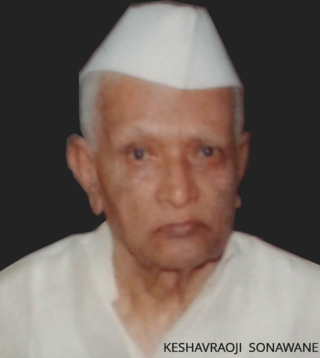
Keshavrao Sonawane (1925–2006) was an Indian politician, who served four terms in the Maharashtra Legislative Assembly, and was a Co-operative minister in Yashwantrao Chavan's cabinet and later Vasantrao Naik's cabinet during 1962–1967. He was elected as Member of Maharashtra Legislative Assembly for 4 times, twice from Latur constituency and twice from Ausa constituency.
Yenegur is a major village located in Omerga tehsil of Osmanabad district, which is part of the Marathwada region of the state of Maharashtra in India.
