Related Research Articles

A weather balloon, also known as a sounding balloon, is a balloon that carries instruments to the stratosphere to send back information on atmospheric pressure, temperature, humidity and wind speed by means of a small, expendable measuring device called a radiosonde. To obtain wind data, they can be tracked by radar, radio direction finding, or navigation systems. Balloons meant to stay at a constant altitude for long periods of time are known as transosondes. Weather balloons that do not carry an instrument pack are used to determine upper-level winds and the height of cloud layers. For such balloons, a theodolite or total station is used to track the balloon's azimuth and elevation, which are then converted to estimated wind speed and direction and/or cloud height, as applicable.

A weather station is a facility, either on land or sea, with instruments and equipment for measuring atmospheric conditions to provide information for weather forecasts and to study the weather and climate. The measurements taken include temperature, atmospheric pressure, humidity, wind speed, wind direction, and precipitation amounts. Wind measurements are taken with as few other obstructions as possible, while temperature and humidity measurements are kept free from direct solar radiation, or insolation. Manual observations are taken at least once daily, while automated measurements are taken at least once an hour. Weather conditions out at sea are taken by ships and buoys, which measure slightly different meteorological quantities such as sea surface temperature (SST), wave height, and wave period. Drifting weather buoys outnumber their moored versions by a significant amount.
The National Weather Service (NWS) is an agency of the United States federal government that is tasked with providing weather forecasts, warnings of hazardous weather, and other weather-related products to organizations and the public for the purposes of protection, safety, and general information. It is a part of the National Oceanic and Atmospheric Administration (NOAA) branch of the Department of Commerce, and is headquartered in Silver Spring, Maryland, within the Washington metropolitan area. The agency was known as the United States Weather Bureau from 1890 until it adopted its current name in 1970.
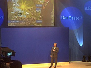
A weather presenter is a person who presents the weather forecast daily on radio, television or internet news broadcasts.

An automatic weather station (AWS) is an automated version of the traditional weather station, either to save human labor or to enable measurements from remote areas. An AWS will typically consist of a weather-proof enclosure containing the data logger, rechargeable battery, telemetry (optional) and the meteorological sensors with an attached solar panel or wind turbine and mounted upon a mast. The specific configuration may vary due to the purpose of the system. The system may report in near real time via the Argos System, LoRa and the Global Telecommunications System, or save the data for later recovery.
The National Severe Storms Laboratory (NSSL) is a National Oceanic and Atmospheric Administration (NOAA) weather research laboratory under the Office of Oceanic and Atmospheric Research. It is one of seven NOAA Research Laboratories (RLs).
Weather spotting is observing weather for the purpose of reporting to a larger group or organization. Examples include National Weather Service (NWS) co-op observers and Skywarn storm spotters.
The Philippine Atmospheric, Geophysical and Astronomical Services Administration is the National Meteorological and Hydrological Services (NMHS) agency of the Philippines mandated to provide protection against natural calamities and to ensure the safety, well-being and economic security of all the people, and for the promotion of national progress by undertaking scientific and technological services in meteorology, hydrology, climatology, astronomy and other geophysical sciences. Created on December 8, 1972, by reorganizing the Weather Bureau, PAGASA now serves as one of the Scientific and Technological Services Institutes of the Department of Science and Technology.

ARMOR Doppler weather radar is a C-Band, Dual-Polarimetric Doppler Weather Radar, located at the Huntsville International Airport in Huntsville, Alabama. The radar is a collaborative effort between WHNT-TV and the University of Alabama in Huntsville. Live data for the radar is only available to a limited audience, such as UAH employees and NWS meteorologists. All ARMOR data is archived at the National Space Science and Technology Center located on the UAH campus.

The Citizen Weather Observer Program (CWOP) is a network of privately owned electronic weather stations concentrated in the United States but also located in over 150 countries. Network participation allows volunteers with computerized weather stations to send automated surface weather observations to the National Weather Service (NWS) by way of the Meteorological Assimilation Data Ingest System (MADIS). This data is then used by the Rapid Refresh (RAP) and other forecast models to produce forecasts. Observations are also redistributed to the public.

In meteorology and climatology, a mesonet, portmanteau of mesoscale network, is a network of automated weather and, often also including environmental monitoring stations, designed to observe mesoscale meteorological phenomena and/or microclimates.

Meteorological instruments, including meteorological sensors, are the equipment used to find the state of the atmosphere at a given time. Each science has its own unique sets of laboratory equipment. Meteorology, however, is a science which does not use much laboratory equipment but relies more on on-site observation and remote sensing equipment. In science, an observation, or observable, is an abstract idea that can be measured and for which data can be taken. Rain was one of the first quantities to be measured historically. Two other accurately measured weather-related variables are wind and humidity. Many attempts had been made prior to the 15th century to construct adequate equipment to measure atmospheric variables.
The Coastal-Marine Automated Network (C-MAN) is a meteorological observation network along the coastal United States. Consisting of about sixty stations installed on lighthouses, at capes and beaches, on near shore islands, and on offshore platforms, the stations record atmospheric pressure, wind direction, speed and gust, and air temperature; however, some C-MAN stations are designed to also measure sea surface temperature, water level, waves, relative humidity, precipitation, and visibility.
Charles "Topper" Shutt is Chief Meteorologist at WUSA Channel 9 in Washington, D.C., and forecaster for WHUR-FM.

Airport weather stations are automated sensor suites which are designed to serve aviation and meteorological operations, weather forecasting and climatology. Automated airport weather stations have become part of the backbone of weather observing in the United States and Canada and are becoming increasingly more prevalent worldwide due to their efficiency and cost-savings.
Surface weather observations are the fundamental data used for safety as well as climatological reasons to forecast weather and issue warnings worldwide. They can be taken manually, by a weather observer, by computer through the use of automated weather stations, or in a hybrid scheme using weather observers to augment the otherwise automated weather station. The ICAO defines the International Standard Atmosphere (ISA), which is the model of the standard variation of pressure, temperature, density, and viscosity with altitude in the Earth's atmosphere, and is used to reduce a station pressure to sea level pressure. Airport observations can be transmitted worldwide through the use of the METAR observing code. Personal weather stations taking automated observations can transmit their data to the United States mesonet through the Citizen Weather Observer Program (CWOP), the UK Met Office through their Weather Observations Website (WOW), or internationally through the Weather Underground Internet site. A thirty-year average of a location's weather observations is traditionally used to determine the station's climate. In the US a network of Cooperative Observers make a daily record of summary weather and sometimes water level information.

National Weather Service Lincoln, Illinois also known as National Weather Service Central Illinois is a weather forecast office responsible for monitoring weather conditions for 35 counties in Central and Southeastern Illinois. The Central Illinois office initially consisted of two forecast offices in Peoria and Springfield until the current location in Lincoln became the sole local forecast office in 1995. Federal meteorology offices and stations in the region date back to the 19th century when the Army Signal Service began taking weather observations using weather equipment at the Springer Building in Springfield. Since that time the presence of the National Weather Service greatly increased with the installation of new weather radars, stations and forecast offices. The current office in Lincoln maintains a WSR-88D (NEXRAD) radar system, and Advanced Weather Interactive Processing System (AWIPS) that greatly improve forecasting in the region. Lincoln is in charge of weather forecasts, warnings and local statements as well as aviation weather.

Erica Alicia Grow-Cei is an American meteorologist and television reporter for WPIX Channel 11 in New York City.

A Road Weather Information System (RWIS) comprises automatic weather stations (AWS) in the field, a communication system for data transfer, and central systems to collect field data from numerous ESS. These stations measure real-time atmospheric parameters, pavement conditions, water level conditions, visibility, and sometimes other variables. Central RWIS hardware and software are used to process observations from ESS to develop nowcasts or forecasts, and to display or disseminate road weather information in a format that can be easily interpreted by a manager. RWIS data are used by road operators and maintainers to support decision making. Real-time RWIS data is also used by Automated Warning Systems (AWS). The spatial and temporal resolution of a station network can be that of a mesonet or sometimes a constituent network in a network of station networks comprising a mesonet. The data is often considered proprietary although it is typically ingested into the major numerical weather prediction models.
Meteorological Service Singapore (MSS) is the national meteorological service of Singapore. It is responsible for gathering and recording weather data across the country, issuing weather forecasts, and performing research into Singapore's weather and climate. It is a division of the National Environment Agency, a statutory board under the Ministry of Sustainability and the Environment.
References
- 1 2 3 4 5 6 7 McManus, Kevin. "A Bright Forecast for a New Venture." The Washington Post 24 November 1994: Style Plus.
- ↑ "Topper Shutt | Chief Meteorologist". www.wusa9.com. February 23, 2011. Archived from the original on May 22, 2011. Retrieved February 22, 2024.
- 1 2 3 4 5 6 7 8 Automated Weather Source Demo , retrieved 2024-02-20
- 1 2 Automated Weather Source Promo WUSA-TV 9 , retrieved 2024-02-22
- ↑ Girard, Keith F. "Storm Spotters Keep Eyes on Skies." The Washington Post 9 May 1985: MD1.
- ↑ Texas Weather Instruments. "Downloads -- Weather Instruments by Texas Weather Instruments, Inc." 27 September 2001. Texas Weather Instruments, Inc. 29 May 2011 < "Weather Instruments by Texas Weather Instruments, Inc". Archived from the original on 2011-07-17. Retrieved 2011-06-03.>
- ↑ Hotchkiss, Mari R. "Company Paves Meteorological Information Highway." Computer Digest (1994): Vol. 9 No. 3.
- ↑ "National Weather Service. JetStream -- Automated Surface Observing Systems". NOAA . Retrieved February 22, 2024.
- ↑ Leffler, R.J. and J.W. Schiesl. "Issues Concerning the Interpretation of Non-Standard Temperature Observations by National Weather Service Forecast Offices." National Weather Service (1994).
- ↑ Meyer, S.J. and K.G. Hubbard. "Nonfederal Automated Weather Stations and Networks in the United States and Canada: a Preliminary Survey." American Meteorological Society (1992): 449-457.
- ↑ Davey, Christopher A., et al. "Differences Between Rooftop and Ground-Based Surface Temperatures." 6th Symposium on Integrated Observing Systems, 82nd AMS Annual Meeting. Orlando: Colorado State University, 2002. 6.2.
- ↑ "Web Page Under Construction". 2017-12-07. Archived from the original on 2017-12-07. Retrieved 2024-02-20.
- ↑ "Weatherbug". weather.weatherbug.com. Archived from the original on July 15, 2011. Retrieved February 22, 2024.
- ↑ Automated Weather Source WBAL Promo , retrieved 2024-02-20
- ↑ "Taking the Pulse of the Planet" (PDF). Germantown, MD: Earth Networks. 2012. Archived (PDF) from the original on 19 July 2019.
- ↑ Allemann, Andrew (13 September 2018). "Amazon buys AWS.com domain name". Domain Name Wire. Archived from the original on 20 March 2023.