The Alpine Lakes Wilderness is a large wilderness area spanning the Central Cascades of Washington state in the United States. The wilderness is located in parts of Wenatchee National Forest and Snoqualmie National Forest, and is approximately bounded by Interstate 90 and Snoqualmie Pass to the south and U.S. Route 2 and Stevens Pass to the north. The Alpine Lakes is the largest wilderness area near the population centers of Puget Sound, counted at 414,161 acres (167,605 ha) following the 2014 expansion.

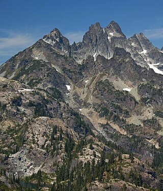
Lemah Mountain is a mountain peak in the Snoqualmie Crest, a part of the North Cascades Mountains, of the US state of Washington, most noted for its five distinct summits. It is approximately 7.7 miles (12.4 km) from Snoqualmie Pass. The name Lemah comes from the Chinook Jargon word Lemah, in turn derived from a French word, le main, meaning "hand". Lemah Mountain formed by rocks crumpled into mountains by the Cascadia subduction zone where the Juan de Fuca and North American Plates meet.

Chimney Rock is a mountain located in the Alpine Lakes Wilderness of the Central Cascade Range in western Washington, United States. The mountain has two main summits, a northeast spire and a central spire, as well as a minor south peak. Situated 10 miles NNE of Snoqualmie Pass, with its craggy appearance Chimney Rock is the most distinctive peak on the crest dividing the Snoqualmie River and Yakima River drainage areas. Lemah Mountain is to the south on the crest, and Summit Chief Mountain to the northeast. Overcoat Peak is off the main ridge just to the north of Chimney Rock. The mountain has three glaciers: the Overcoat Glacier on the north, the Chimney Glacier on the south and east, and an unnamed glacier on the east side of the North Peak.

Overcoat Peak is in Mount Baker-Snoqualmie National Forest in the U.S. state of Washington. Overcoat Peak is less than .40 mi (0.64 km) northwest of Chimney Rock and both are within the Alpine Lakes Wilderness. Overcoat Glacier is on the east slopes of Overcoat Peak.

Summit Chief Mountain is a 7,467-foot (2,276-meter) mountain summit located on the county line separating King County and Kittitas County in Washington state. It is entirely within the Alpine Lakes Wilderness, on land managed by Mount Baker-Snoqualmie National Forest. Summit Chief Mountain is situated on the crest of the Cascade Range, nine miles northeast of Snoqualmie Pass. Precipitation runoff from the west side of the mountain drains into tributaries of the Snoqualmie River, whereas the east side drains into tributaries of the Yakima River. The nearest higher peak is Chimney Rock, 1.29 miles (2.08 km) to the southwest.

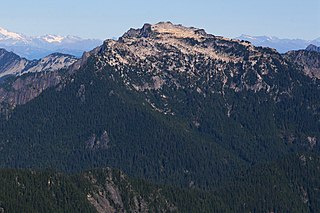
Mount Defiance is a 5,584-foot (1,702-metre) mountain summit located in King County of Washington state. It's part of the Cascade Range and is within the Alpine Lakes Wilderness. Mount Defiance is situated 6.5 mi (10.5 km) west of Snoqualmie Pass on land managed by Mount Baker-Snoqualmie National Forest. Precipitation runoff on the mountain drains into tributaries of the Snoqualmie River. The nearest higher peak is Granite Mountain, 3.96 mi (6.37 km) to the east-southeast, and Bandera Mountain is 1.85 mi (2.98 km) to the southeast. Mount Defiance can be reached by trail, with access via the Ira Spring, Talapus Lake, or Pratt Lake trailheads.

Mount Thomson is a prominent 6,554-foot-elevation (1,998-meter) mountain summit in eastern King County of Washington state.

Big Snow Mountain is a prominent 6,680-foot (2,040-metre) mountain summit located 7 mi (11 km) north of Snoqualmie Pass in the Alpine Lakes Wilderness in eastern King County of Washington state. It is part of the Cascade Range and is situated on land managed by Mount Baker-Snoqualmie National Forest. Precipitation runoff from the mountain drains into tributaries of the Snoqualmie and Skykomish Rivers. The nearest higher peak is Overcoat Peak, 3.75 mi (6.04 km) to the east-southeast.

Little Big Chief Mountain is a 7,225-foot (2,202-metre) mountain summit located immediately southwest of Dutch Miller Gap, on the common border separating King County and Kittitas County in Washington state. It is situated within the Alpine Lakes Wilderness, on land managed by Mount Baker-Snoqualmie National Forest. Little Big Chief Mountain is set ten miles northeast of Snoqualmie Pass on the crest of the Cascade Range. Precipitation runoff from the west side of the mountain drains into tributaries of the Snoqualmie River, whereas the east side drains into tributaries of the Yakima River. The nearest higher peak is Summit Chief Mountain, 0.7 miles (1.1 km) to the southwest, and Chimney Rock is set 2.2 miles (3.5 km) to the southwest. The first ascent of this peak was made in August 1939 by Fred Beckey, Wayne Swift, Joe Barto, and Campbell Brooks. This mountain was named for Lorenz A. Nelson during the 1925 Mountaineers climb of Summit Chief Mountain. Nelson was a pioneering mountaineer who led first ascents of Mount Olympus, Mount Meany, and Chiwawa Mountain.

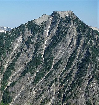
Burnt Boot Peak is a 6,540-foot (1,993-metre) mountain summit located in the Alpine Lakes Wilderness in eastern King County of Washington state. The peak is part of the Cascade Range and is one mile east of the crest of the range. Burnt Boot Peak is situated 6.5 mi (10.5 km) northeast of Snoqualmie Pass on land managed by Mount Baker-Snoqualmie National Forest. Huckleberry Mountain is set 1.87 mi (3.01 km) to the south, and the nearest higher neighbor is Lemah Mountain, 1.34 mi (2.16 km) to the east. This unofficially-named mountain is located at the head of the officially-named Burnboot Creek, variant spelling Burntboot Creek. Precipitation runoff from the mountain drains south into this creek, or north into Middle Fork Snoqualmie River. The first ascent of this peak was made in August 1963 by Phil Weiser and Clarke Stockwell. The first ascent via the north ridge route was made in June 1971 by Don Williamson, Tom Oas, and Bill Bucher.
Lake Augusta is a freshwater lake located on the southwest skirt of Big Jim Mountain, East of Icicle Ridge, in Chelan County, Washington. Because of its close proximity to Icicle Ridge Trail, the lake is a popular area for hiking, swimming, and fishing cutthroat trout. Smaller Lake Ida is a short distance on the opposite side of Icicle Ridge and Big Jim Mountain Lakes or on the northeast slope of the mountain. Lake Augusta is located approximately 15 miles west of the city of Leavenworth. Self-issued Alpine Lake Wilderness permit required for transit within the Lake Augusta area.
Lake Ida is a freshwater lake located along Icicle Ridge, approximately 10 miles west of the city of Leavenworth in Chelan County, Washington. Because of its close proximity to Icicle Ridge Trail, the lake is a popular area for hiking, swimming, and fishing cutthroat trout. Lake Augusta is a short distance on the opposite side of Icicle Ridge. Lake Ida sits on a highly glaciated alpine cirque, surrounded by a coniferous forest primarily larch pines and outflows into Ida Creek, a tributary of Icicle Creek. At least one unrated waterfall is found downstream as Ida Creek runs the south slope of Icicle Ridge. Self-issued Alpine Lake Wilderness permit required for transit within the Lake Ida and Augusta area.

Lake Edna is a freshwater lake located along Icicle Ridge, approximately 10 miles west of the city of Leavenworth in Chelan County, Washington. Because of its close proximity to Icicle Ridge Trail, the lake is a popular area for hiking, swimming, and fishing. Lake Alice is a short distance in a prominent cirque on the opposite side of Icicle Ridge.

Alaska Lake is a freshwater lake located on the western skirt of Alaska Mountain at the border between King County and Kittitas County, Washington. The lake is a popular area for hiking, swimming, and fishing. Other Alpine lakes are in the vicinity, including the Rampart Lakes a short distance south, at the base of Mount Margaret. To the east is Hibox Mountain.
Angeline Lake is a freshwater lake located on the northern slope of Iron Cap Mountain between Otter Lake, Azure Lake and Big Heart Lake, in King County, Washington. Self-issued Alpine Lake Wilderness permit required for transit within the Big Snow Mountain area. West Fork Foss River exits Angeline Lake into a canyon that produces Angeline Falls downstream from Chetwoot Lake to Delta Lake. Because Angeline Lake is at the heart of the Alpine Lakes Wilderness, the lake is a popular area for hiking, swimming, and fishing golden trout, rainbow trout, and cutthroat trout.
Chetwoot Lake is a freshwater lake located on the western slope of Iron Cap Mountain next to Crawford Lake, in King County, Washington. West Fork Foss River exits Chetwoot Lake towards Angeline Lake and then to a canyon that produces Angeline Falls downstream towards Delta Lake. Because Chetwoot Lake is at the heart of the Alpine Lakes Wilderness, the lake is a popular area for hiking, swimming, and fishing.
Chikamin Lake is a small alpine freshwater lake located on the northern skirt of Chikamin Peak and Lemah Mountain in King County, Washington. Because of its proximity to surrounding peaks and mountains at the heart of the Alpine Lakes Wilderness, the lake is a popular area for hiking. Other Alpine lakes are in the vicinity, including the Icebox Lake, Glacier Lake and Spectacle Lake a short distance South, at the base of Chikamin Ridge. To the North is Avalanche Lake and Iceberg Lake.

Spectacle Lake is an alpine freshwater lake located on the northern skirt of Chikamin Peak and Lemah Mountain in Kittitas County on its western border with King County, Washington. Because of its proximity to surrounding peaks and mountains at the heart of the Alpine Lakes Wilderness, the lake is a popular area for hiking, camping and fishing cutthroat trout. Other Alpine lakes are in the vicinity, including the Chikamin Lake, a short distance North, at the base of Chikamin Peak. To the South is Hibox Mountain.
Glacier Lake is a small alpine freshwater lake located on the northern skirt of Chikamin Peak and Lemah Mountain in Kittitas County, Washington. Because of its proximity to surrounding peaks and mountains at the heart of the Alpine Lakes Wilderness, the lake is a popular area for hiking, camping, and fishing golden trout. Glacier Lake is a short distance between Chikamin Lake and Spectacle Lake at the base of Chikamin Ridge. The Pacific Crest Trail is a short distance from Glacier Lake as well as other Alpine lakes located in the vicinity. To the North is Avalanche Lake and Iceberg Lake at the base of Lemah Mountain.
Chiwaukum Lake is an alpine freshwater lake located on the Ewing Basin south of Lake Donald and the McCue Ridge in King County, Washington. Because of its proximity to surrounding peaks and mountains at the heart of the Alpine Lakes Wilderness, the lake is a popular area for hiking. Outflow from Chiwaukum Lake is Chiwaukum Creek and an unnamed creek flows into Chiwaukim Lake from Larch Lake. A short distance north of Donald Lake are other Scottish Lakes including Loch Eileen and Lake Julius.


