
Ariyalur district is an administrative district, one of the 38 districts in the state of Tamil Nadu in India. The district headquarters is located at Ariyalur. The district encompasses an area of 1,949.31 km².
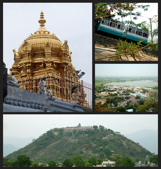
Palani (Tamil:[paɻani], is a town and a taluk headquarters in Dindigul district of the western part of Tamil Nadu state in India. It is located about 106 kilometres south-east of Coimbatore and 122 kilometres north-west of Madurai, 67 kilometres from Kodaikanal. The Palani Murugan Temple or Arulmigu Dhandayuthapani Swamy Temple, dedicated to Murugan is situated on a hill overlooking the town. The temple is visited by more than 7 million pilgrims each year. As of 2011, the town had a population of 292301 which makes it the second largest town in the district after Dindigul.

Rayavaram is a village Panchayat in Pudukkottai district in Tamil Nadu, India.

Melur is the Northern entrance of Madurai district. It is the town and municipality in the Madurai North in the Indian state of Tamil Nadu. Melur Old Name is Called Naduvi Nadu. The name Melur name comes from "Mela Nadu". Melur is called Thaigramam. It is the biggest taluk within the Madurai District. As of 2011, the town had a population of 40,017. Melur is an agricultural land in Madurai and the climate around the area is tropical.
Puzhuthivakkam, commonly known as Ullagaram or Ullagaram–Puzhuthivakkam, is a southern neighbourhood of Chennai in Tamil Nadu, India. Puzhuthivakkam loosely translates to dust neighborhood. The neighbourhood is part of the Greater Chennai Corporation, following Chennai's expansion into Kanchipuram district. Puzhuthivakkam is located between the neighborhoods of Madipakkam, Adambakkam, Velachery, Pallikaranai, and Nanganallur. Puzhuthivakkam was initially developed in the late 1960s and early 1970s. Upon completion of the MRTS extension line, the neighborhood will be served by Puzhuthivakkam railway station. As of 2011, the town had a population of 53,322.
V.S.K.Valasai is a city in Dindigul district in the Indian state of Tamil Nadu.
Anakaputhur is a neighborhood in the city of Tambaram, situated within the Chennai Metropolitan Area, Tamil Nadu, India.
Cumbum, natively spelt as Kambam, is a town and municipality in Theni district, an Indian state of Tamil Nadu.
Pudupatti is a panchayat village in Thanjavur district and sub-district in the Indian state of Tamil Nadu.
Budalur is a small town located in Thanjavur district of Tamil Nadu. There is a famous historic Shiva temple known as the Abathsagayeshwarar Temple situated in Budalur, built by Great Emperor Raja Raja Cholan(who built the Big temple in Thanjavur) during 10th century. This place is easy to access from, Thanjavur by 20 kilometers and Tiruchirapalli by 34 kilometers with both Railways and roadways.

Peikkarumbankottai is a village in the Orathanadu taluk of Thanjavur district, Tamil Nadu, India.
Pinnaiyur is a village in Thanjavur district of the Indian state of Tamil Nadu. It is located in Orathanadu taluk.
Samipatti is a village in the Orathanadu taluk of Thanjavur district, Tamil Nadu, India.
Vellur is a village in the Orathanadu taluk of Thanjavur district in the Indian state of Tamil Nadu. Vellur, also known as Vellur Nadu, is an agricultural village.
Udayalur is a village in the Kumbakonam taluk of Thanjavur district, Tamil Nadu, India. Udayalur is a few kilometers away from the historic Chola dynasty stronghold town of Kizha Pazhayarai. The village was historically called SriKangeyapuram.
Nemmeli is an agricultural village in Madukkur Panchayat Union, Pattukkottai taluk of Thanjavur district, Tamil Nadu, India, also known as 28.Nemmeli. Nemmeli village is division of Musugundha Nadu in Chola nadu. It comes under Pattukottai legislative constituency and Tanjore Parliament constituency. It is a small and well developing Village located in southern part of Tamil Nadu. It is 15 km from Pattukkottai and Mannargudi. It is surrounded with number of villages. Being in the Cauvery River Delta Area the inhabitants’ main occupation is agriculture. The younger generation is well educated and they working Various Location in India and also in foreign countries like Singapore, Malaysia, UAE, Saudi Arabia, UK and USA. Many people's working in foreign countries Like Saudi Arabia, Singapore, UK, USA, etc. The economy is booming in line with India’s rapid economic development. Nemmeli Seawater Desalination Plant located in the township is a major drinking water supply source for South Chennai since 2010.
Palathali is a village in the Pattukkottai taluk of Thanjavur district, Tamil Nadu, India. It is also known as "Durkkai Amman Kovil" due to the temple which is located there. Agriculture is the main activity, which is extensively done in "muppogam" three times a year. This place depends on "Kaveri" river water and borewells for farming rice. Rice cultivation is the main agricultural activity. Many people go abroad for work.
Mariamman Kovil or Punnainallur is a village in the district of Thanjavur, Tamil Nadu, India. It is located 6 km east of Thanjavur town, on the Thanjavur - Nagapattinam Highway. It is home to the amman Punnainallur Mariamman temple. The village is also home to the Kathaiamman Temple and few other temples in the surroundings. It can be reached by road via public transport from Thanjavur town with many buses plying from there. The nearest railway station is Thanjavur Junction, and nearest airport is Tiruchirappalli International Airport
Avanam is a village in Peravurani taluk, Thanjavur district, Tamil Nadu, India. In 2011, it had a population of 3,051 with 1,421 males and 1,630 females.

