
Yosemite National Park is an American national park located in the western Sierra Nevada of Central California, bounded on the southeast by Sierra National Forest and on the northwest by Stanislaus National Forest. The park is managed by the National Park Service and covers an area of 748,436 acres and sits in four counties: centered in Tuolumne and Mariposa, extending north and east to Mono and south to Madera County. Designated a World Heritage site in 1984, Yosemite is internationally recognized for its granite cliffs, waterfalls, clear streams, giant sequoia groves, lakes, mountains, meadows, glaciers, and biological diversity. Almost 95% of the park is designated wilderness.

The Sierra Nevada is a mountain range in the Western United States, between the Central Valley of California and the Great Basin. The vast majority of the range lies in the state of California, although the Carson Range spur lies primarily in Nevada. The Sierra Nevada is part of the American Cordillera, an almost continuous chain of mountain ranges that forms the western "backbone" of the Americas.
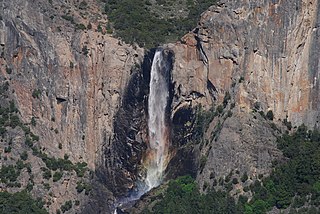
Bridalveil Fall is one of the most prominent waterfalls in the Yosemite Valley in California. The waterfall is 188 metres (617 ft) in height and flows year round.
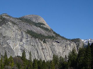
North Dome is a granite dome in Yosemite National Park, California. It is the southernmost summit of Indian Ridge, 0.6 miles (1.0 km) north of Washington Column and the Royal Arches on the northeastern wall of Yosemite Valley. It can be reached by trail from the Tioga Pass Road, or by going up the Yosemite Falls trail and heading east. It can also be reached from Mirror Lakes by the Snow Creek Falls trail going north around Indian Rock and then south again on the Tioga Pass Road trail. The South Face is precipitous.

Tenaya Lake is an alpine lake in Yosemite National Park, located between Yosemite Valley and Tuolumne Meadows. The surface of Tenaya Lake has an elevation of 8,150 feet (2,484 m). The lake basin was formed by glacial action, which left a backdrop of light granite rocks, whose beauty was known to the Native Americans. Today, Tenaya Lake is easily accessible by State Route 120 and is a popular lake for water activities.

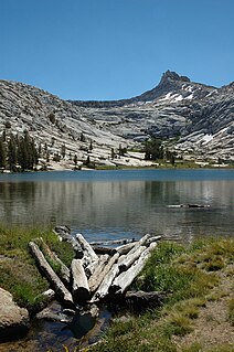
The Cathedral Lakes are two lakes located In Yosemite National Park, Mariposa County, California. The lakes are situated 1.6 km (1 mi) southwest of Cathedral Peak and 3.2 km (2 mi) east-northeast of Tenaya Lake. The lower lake is located at elevation 9,288 feet (2,831 m), while the upper lake is located at elevation 9,585 feet (2,922 m). The John Muir Trail is nearby, with a 7 miles (11 km) round trip hike from the trailhead in Tuolumne Meadows.

Ostrander Lake is located in Yosemite National Park, approximately 10 miles (16 km) south of Yosemite Valley and 10 miles (16 km) east of the Badger Pass Ski Area, at an elevation of 8,500 feet (2,600 m). The lake is a popular destination for cross-country skiers during the winter. It is the primary source of Bridalveil Creek, which feeds Bridalveil Falls.
Flora Lake is a remote lake located in the northern environs of Yosemite National Park, California, United States. The lake is located in a rugged environment that is only accessible to intrepid hikers.

Mirror Lake is a small, seasonal lake located on Tenaya Creek in Yosemite National Park. Situated in Tenaya Canyon directly between North Dome and Half Dome, it is the last remnant of a large glacial lake that once filled most of Yosemite Valley at the end of the last Ice Age, and is close to disappearing due to sediment accumulation.
Adair Lake is a lake within the backcountry of Yosemite National Park, in the Sierra Nevada, Madera County, California.
Ardeth Lake is a lake in Tuolumne County, California, in the United States.

Arndt Lake is a lake in Yosemite National Park, in California.
Babcock Lake is a lake in Yosemite National Park of California.
Benson Lake is a lake in Yosemite National Park, United States.
Bernice Lake is a lake in Yosemite National Park, United States.
Big Island Lake is a lake in Yosemite National Park, United States.
Boothe Lake is a lake in Yosemite National Park, United States.
Boundary Lake is a lake in Tuolumne County, California, in the United States.
Branigan Lake is a lake in Yosemite National Park, California.
Budd Lake is a lake in the Tuolumne Meadows region of Yosemite National Park, United States. Budd Lake is the source of Budd Creek.
