
Paros is a Greek island in the central Aegean Sea. Part of the Cyclades island group, it lies to the west of Naxos, from which it is separated by a channel about 8 kilometres wide. It lies approximately 150 km south-east of Piraeus. The Municipality of Paros includes numerous uninhabited offshore islets totaling 196.308 square kilometres (75.795 sq mi) of land. Its nearest neighbor is the municipality of Antiparos, which lies to its southwest. In ancient Greece, the city-state of Paros was located on the island.
Messenia or Messinia is a regional unit in the southwestern part of the Peloponnese region, in Greece. Until the implementation of the Kallikratis plan on 1 January 2011, Messenia was a prefecture (nomos) covering the same territory. The capital and largest city of Messenia is Kalamata.

Grevena is a town and municipality in Western Macedonia, northern Greece, capital of the Grevena regional unit. The town's current population is 12,515 citizens (2021). It lies about 420 kilometres from Athens and about 180 km from Thessaloniki. The municipality's population is 25,905. Grevena has had access to the Egnatia Odos since the early 2000s, which now connects Igoumenitsa with Thessaloniki and Alexandroupoli at the border with Turkey. Mountains surround the municipality, which is situated by the river Greveniotikos, which itself flows into the Aliakmon. Other significant towns in the municipality are Amygdaliés and Méga Seiríni. Grevena Municipal Museum is located in the town.

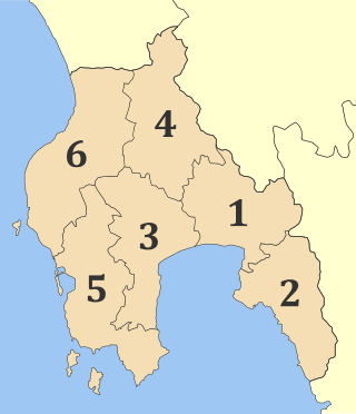
Kalamata is the second most populous city of the Peloponnese peninsula, after Patras, in southern Greece and the largest city of the homonymous administrative region. As the capital and chief port of the Messenia regional unit, it lies along the Nedon River at the head of the Messenian Gulf.

Pyrgos is a city in the northwestern Peloponnese, Greece, capital of the regional unit of Elis and the seat of the Municipality of Pyrgos. The city is located in the middle of a plain, 4 kilometres from the Ionian Sea. The river Alfeios flows into sea about 7 km (4 mi) south of Pyrgos. The population of the town Pyrgos is 26,052, and of the municipality 45,365 (2021). Pyrgos is 16 km (10 mi) west of Olympia, 16 km (10 mi) southeast of Amaliada, 70 km (43 mi) southwest of Patras and 85 km (53 mi) west of Tripoli.
Pastra is a village and a community in the southeastern part of the island of Kefalonia, Greece. It was the seat of the municipality of Eleios-Pronnoi. The community consists of the villages Pastra and Kremmydi. Pastra is 2 km northeast of Markopoulo, 3 km south of Agia Eirini, 5 km northwest of Skala, 6 km southwest of the port town of Poros and 25 km southeast of Argostoli.

Petalidi is a village and a former municipality in Messenia, Peloponnese, Greece. Since the 2011 local government reform it is part of the municipality Messini, of which it is a municipal unit. The municipal unit has an area of 104.970 km2. Petalidi is situated on the western shore of the Messenian Gulf, 14 km southwest of Messini, 20 km southwest of Kalamata and 25 km east of Pylos. The road Greek National Road 82 passes through the north of the municipal unit. Its population is 1,203 inhabitants, while the municipal unit has 2,555 residents (2021).
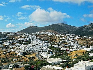
Sifnos is an island municipality in the Cyclades island group in Greece. The main town, near the center, known as Apollonia, is home of the island's folklore museum and library. The town's name is thought to come from an ancient temple of Apollo on the site of the church of Panayia Yeraniofora. The second-largest town is Artemonas, thought to be named after an ancient temple of Apollo's sister Artemis, located at the site of the church of Panayia Kokhi. The village of Kastro, was the capital of the island during ancient times until 1836. It is built on top of a high cliff on the island's east shore and today has extensive medieval remains and is the location of the island's archeological museum. The port settlement, on the west coast of the island is known as Kamares.

Farsala, known in Antiquity as Pharsalos, is a city in southern Thessaly, in Greece. Farsala is located in the southern part of Larissa regional unit, and is one of its largest towns. Farsala is an economic and agricultural centre of the region. Cotton and livestock are the main agricultural products, and many inhabitants are employed in the production of textile. The area is mostly famous for being the birthplace of the mythical ancient Greek hero Achilles, and the site of a major battle between Roman generals Gaius Julius Caesar and Gnaeus Pompeius Magnus in 48 BC.

Kozani is one of the regional units of Greece. It is part of the region of Western Macedonia, in the geographic region of Macedonia. Its capital is the city of Kozani.

Engomi is a suburb and municipality of the Cypriot capital Nicosia. In 2011, it had a population of 18,010. Of these, 14,254 were citizens of Cyprus.

Androusa is a village and a former municipality in Messenia, Peloponnese, Greece. Since the 2011 local government reform it is part of the municipality Messini, of which it is a municipal unit. The municipal unit has an area of 50.514 km2. Predominantly a farming region, the principal exports include kalamata olives, olive oil, and livestock. It is located 22 km north-west of the regional capital Kalamata. Municipal unit population 1,800 (2021), village population 522 (2021).

Aristomenis is a village and a former municipality in Messenia, Peloponnese, Greece. Since the 2011 local government reform it is part of the municipality Messini, of which it is a municipal unit. The municipal unit has an area of 90.678 km2. Population 1,696 (2021).

Ithomi is a municipal unit of the municipality (dimos) of Messini within the regional unit of Messenia in the region (perifereia) of Peloponnese, one of 13 regions into which Greece has been divided. Before 2011 the same hierarchy prevailed, according to Law 2539 of 1997, the Kapodistrias Plan, except that Messenia was a nomos and Ithomi a demos, with seat in Valyra. The lowest-level units were the same with the same populations in either system but where before 2010 they were Local Divisions, after it they were Local Communities. The municipal unit has an area of 90.428 km2.

Trikorfo is a former community in Messenia, Peloponnese, Greece. Since the 2011 local government reform it is part of the municipality Messini, of which it is a municipal unit. The municipal unit has an area of 42.938 km2. Population 473 (2021). The average altitude of Trikorfo village is 398 meters. It is famous place because of the extra quality of olives. The seat of the community was Trikorfo. Predominantly a farming region, the principal exports include kalamata olives, olive oil and figs. The community was divided into Trikorfo, Mavros Logkos, Chilia Spitia, Draina Klima, Koromilea, Palaiokastro, Kinigos. Trikorfo village is also known as Pentias. Common family names in Trikorfo include Skoufis and Katsipodas.

Shamlugh is a village in the Lori Province in northeastern Armenia. It is situated on the left bank of Debed River, at a road distance of 196 km north of the capital Yerevan and 63 km north of the provincial centre Vanadzor. The village had a majority Greek population; however, it is now predominantly populated by Armenians. According to the 2011 census, Shamlugh had 700 inhabitants, while the 2016 official estimate shows the current population is around 500.
Paramun is a village in Tran Municipality, Pernik Province. It is located in western Bulgaria, 66 km from the capital city of Sofia and 14 km from the town of Tran, near the Serbian border. The toponym is of Byzantine Greek origin, from the loanword paramun meaning "guard, watch, sentry". It was rendered as παραμονή in Greek and was retained in medieval Serbian as ПАРАМОУНЬ. The name was first mentioned in 1451 and 1453.
Messini is a municipal unit and the seat town (edra) of the municipality (dimos) of Messini within the regional unit of Messenia in the region (perifereia) of Peloponnese, one of 13 regions into which Greece has been divided. Before 2011 the same hierarchy prevailed, according to Law 2539 of 1997, the Kapodistrias Plan, except that Messenia was a nomos and the Municipal unit was a locality. The dimos existed under both laws, but not with the same constituents.
Kallithea is a village in the Greek island of Lemnos, part of the municipal unit Nea Koutali. In 2019 its population was 227. The village has drawn criticism worldwide for its various hazing incidents, such as the 2017 death of 12 year old Krystas Mitroglou.
1. History of Avramiou (Messini) Alexandros Giannakopoulos, Athens 1984

