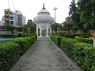
Ballia is a city with a municipal board in the Indian state of Uttar Pradesh. The eastern boundary of the city lies at the junction of two major rivers, the Ganges and the Ghaghara.The city is situated 140 km (87 mi) east of Varanasi and about 380 km from the state capital Lucknow. It has a protected area, the Jai Prakash Narayan bird sanctuary. Ballia is also around 4 km (2.5 mi) away from Bihar.

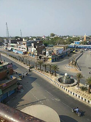
Ballia district is one of the districts of Uttar Pradesh, India. Ballia district is a part of Azamgarh division situated in the east of Uttar Pradesh. The main economic activity is agriculture. City is the district headquarters and commercial market of this district. It is the birthplace of former prime minister of India Chandra Sekhar Singh There are six tehsils in this district: Ballia, Bansdih, Rasra, Bairia, Sikandarpur and Belthara. Rasra is the second major commercial area of the district, having a government sugar mill and a cotton weaving industry. Though Ballia's core occupation is agriculture there are some additional small industries. Maniar is known for its bindi industry and is a major supplier.

Mau district is one of the districts of Uttar Pradesh state of India, and Mau town is the district headquarters which is also one of the few remaining areas of handloom saree production in eastern Uttar Pradesh, specializing in Sadiya silk sarees. Mau was carved out as a separate district from Azamgarh on 19 November 1988. It is situated in the south-eastern part of the state with headquarters in Maunath Bhanjan. The district is surrounded by Ghazipur district on the south, Ballia district in the east, Azamgarh district in the west, and by Gorakhpur and Deoria districts on the north; says, Pallavi mishra.

Varanasi division is one of the 18 administrative geographical units of the northern Indian state of Uttar Pradesh. Varanasi city is the administrative headquarters of the division. The division consists of 4 districts, i.e. Varanasi, Chandauli, Ghazipur, and Jaunpur and is loosely equivalent to the Benares State.
Rasra is a city and a municipal board in Ballia district in the Indian state of Uttar Pradesh. It is one among six tehsils that come under Ballia district, Rasra is also known as 'Chhoti Kashi' and 'Nath Nagri' due to the presence of Nath Baba mandir which is a well known religious spot. In past the production of sugar from rotten sugarcanes lead to the city being named 'Rasra' which is a portmanteau word made-up of two hindi words 'Ras' (रस) meaning juice and 'Sada/Sara' (सड़ा) meaning rotten. It has an important market for the nearby villages. Lounglatta is the famous sweet of Rasra. Dussehra is one of two very prominent festivals, here, alongside Chhath. Rasra has top schools of district. Rasra has second largest Durga Puja celebration in Uttar Pradesh after Ram Nagar, Varanasi. Rasra has a busy fish market, chicken market and mutton narket. It has also Sadar Bazaar, Station Road Market, Hospital Complex Market, Mission Road Market, Kali Maa ka chaura, and This place is known for all religious cultures, and has many of mandir, churches and mosques.
Yusufpur Mohammadabad is a town and a Township in Ghazipur district in the Indian state of Uttar Pradesh. Haydaria village near Mohammadabad is the starting point of Purvanchal Expressway.
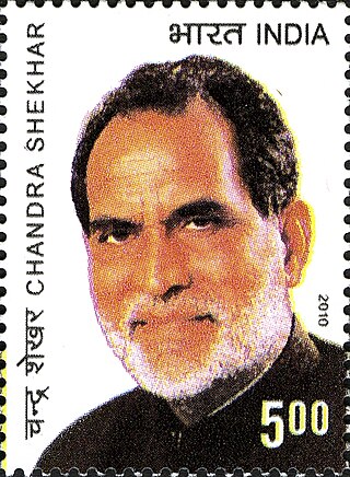
Chandra Shekhar was an Indian politician who served as the 8th Prime Minister of India, between 10 November 1990 and 21 June 1991. He headed a minority government of a breakaway faction of the Janata Dal with outside support from the Indian National Congress. He was the first Indian Prime Minister who had never held any prior government office.
Lalmatia Colliery was a private, underground coal mine at Lalmatia, District- Santhal Paragana. After nationalisation of non-coking coal mines in India during 1973, this mine was taken over by the Indian government and came under Eastern Coalfields Limited.
Ballia Assembly constituency was an assembly constituency in Begusarai district in the Indian state of Bihar.
Bairia is a nagar panchayat in Bairia tehsil in Ballia District of Uttar Pradesh State, India. It belongs to Azamgarh Division. It is located 35 km to the east of the district headquarters Ballia. It is a block headquarters and tehsil headquarters. Bairia is a nagar panchayat located in Bairia Tehsil of Ballia district, Uttar Pradesh with total 3904 families residing. The Bairia nagar panchayat has population of 28394 of which 14981 are males while 13413 are females as per Population Census 2011.
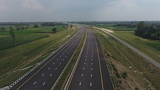
Purvanchal Expressway is a 340.8 km long, 6-lane wide access-controlled expressway in the state of Uttar Pradesh, India. The expressway connects Chand Saray village near Gosainganj in Lucknow district with Haydaria village on NH-31 in Ghazipur district. It is developed by the Uttar Pradesh Expressways Industrial Development Authority (UPEIDA). The Purvanchal Expressway has a 3.2 km long airstrip at Akhalkiri Karwat village near Kurebhar in Sultanpur district for emergency landing of aircraft. The construction work was started by the UPEIDA on 10 October 2018 and was inaugurated and opened to the public on 16 November 2021.
Ratanpura is a census town in the Mau district of Uttar Pradesh. It is located about 25 kilometres east of the district headquarters, Mau, and 47 Kilometres west of Ballia. It is a development block headquarter, which comes under the Mau Sadar Tehsil. The town is situated between the middle of Mau and Ballia. The State Highway 34 passes through Ratanpura. Earlier it was a part of Ballia district, but since 19 November 1988 it became the part of newly constituted Mau District. The town has its own Railway station managed by North Eastern Railway (India) in its name which has connecting trains to Mau, Varanasi, Ballia, Lucknow, Kanpur, Azamgarh, Chhapra and Dhanbad stations to name a few.
Phephna, also spelled as Fefana, is a large village in the Ballia district of Indian state of Uttar Pradesh. This village is situated at about 10 kilometers from District headquarters Ballia.

Thakur Umashankar Singh is an Indian politician and a member of 16th and 17th Legislative Assembly, Uttar Pradesh of India. He represents the Rasara constituency in Ballia district of Uttar Pradesh.
Narahi is a village located in Ballia Sadar tehsil of Ballia district, Uttar Pradesh, India. It has a total of 1,274 families as of 2011. Narahi had a population of 8,960 as per 2011 census.
Maurha is a village and a Gram panchayat in Ballia district in the Indian state of Uttar Pradesh. Its population is 555, per the 2011 Census. Maurha's nearest railway station is Belthara Road. During British India it was a Taluqdari
Jamalpur is a village of Ballia district in the Indian state of Uttar Pradesh. Its population is 269, per the 2011 Census. Jamalpur village is located in Rasra Tehsil of Ballia district in Uttar Pradesh, India. Jamalpur's nearest railway station is Ballia.
Govindpur is a village of Ballia district in the Indian state of Uttar Pradesh. Its population is 469, per the 2011 Census. Govindpur village is located in Ballia Tehsil of Ballia district in Uttar Pradesh, India.
Ballia Nagar is a constituency of the Uttar Pradesh Legislative Assembly covering the city of Ballia Nagar in the Ballia district of Uttar Pradesh, India. It is one of five assembly constituencies in the Ballia Lok Sabha constituency. Since 2008, this assembly constituency is numbered 361 amongst 403 constituencies.
Here a group is active that name is helping hands groups. Group's aim is to save nature, help everyone, help children for their future etc.we want your love and blessings.

