Aytos Point

Last updated
Location of Livingston Island in the South Shetland Islands Livingston-Island-location-map.png
Location of Livingston Island in the South Shetland Islands
Aytos Point Aytos.jpg
Aytos Point
Topographic map of Livingston Island and Smith Island Livingston-Island-Map-2010-15.png
Topographic map of Livingston Island and Smith Island

Aytos Point (Nos Aytos \'nos 'ay-tos\) is a point on the coast of Bransfield Strait, Livingston Island, Antarctica formed by an offshoot of Christoff Cliff. The point was named after the Bulgarian town of Aytos.

Contents

Location

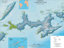
Aytos Point is located at 62°42′23.5″S60°02′59.5″W / 62.706528°S 60.049861°W / -62.706528; -60.049861 Coordinates: 62°42′23.5″S60°02′59.5″W / 62.706528°S 60.049861°W / -62.706528; -60.049861 which is 5.57 km east by north east of Samuel Point and 2.53 km southwest of M'Kean Point.

The point was mapped by the UK Directorate of Overseas Surveys in 1968, and by Bulgaria in 2005 and 2009.

See also

Maps


This article includes information from the Antarctic Place-names Commission of Bulgaria which is used with permission.

Related Research Articles

Amadok Point

Amadok Point is a point on the south coast of Livingston Island, Antarctica which projects 400 m into the Bransfield Strait. The point was named after the Thracian King Amadokos, 415-384 BC. It is snow-free in the summer.

Boyana Glacier

Boyana Glacier in Levski Ridge, Tangra Mountains on Livingston Island, South Shetland Islands in Antarctica is situated southeast of Macy Glacier and west-southwest of Srebarna Glacier. It is bounded by Vazov Rock on the west, St. Naum Peak, Starosel Gate, Silistra Knoll and Kotel Gap on the north, and Christoff Cliff on the east. The glacier extends 3 km in east-west direction and 1.6 km in north-south direction, and flows southeastward into the Bransfield Strait between Vazov Point and Aytos Point.

Magura Glacier

Magura Glacier on the southeast side of Tangra Mountains on Livingston Island in the South Shetland Islands, Antarctica is located to the north of M'Kean Point, northeast of Srebarna Glacier, south of Iskar Glacier and southwest of Dobrudzha Glacier. It is bounded by Great Needle Peak to the west, Vitosha Saddle, Vihren Peak and Helmet Peak to the northwest, Plovdiv Peak and Shishman Peak to the north, and Devin Saddle and Kuber Peak to the northeast. The glacier extends 3.5 km in southwest-northeast direction and 1.9 km in northwest-southeast direction, and flows southeastward into Bransfield Strait.

Melta Point

Melta Point is a rocky point on the coast of Hero Bay, Livingston Island, formed by an offshoot of Teres Ridge. Adjacent ice-free area 116 hectares. The point is named after the ancient Melta, ancestor of the present town of Lovech in Northern Bulgaria. This is one of the Bulgarian names bestowed on hitherto nameless geographical features by the Tangra 2004/05 Expedition.

Ogosta Point

Ogosta Point is located in the central part of Zagore Beach on the east coast of False Bay, Livingston Island in the South Shetland Islands, Antarctica. Situated on Rozhen Peninsula 5.35 km north of Barnard Point, 4.4 km west of St. Methodius Peak and 3.45 km east of Castro Peak. The point is named after the Ogosta River in Bulgaria.

Pomorie Point

Pomorie Point is a point on the coast of McFarlane Strait forming the north side of the entrance to Lister Cove, Varna Peninsula, Livingston Island in the South Shetland Islands, Antarctica.

Prespa Glacier

Prespa Glacier on Rozhen Peninsula, Livingston Island in the South Shetland Islands, Antarctica is situated east-northeast of Tarnovo Ice Piedmont, east of the head of Charity Glacier, southeast of Ruen Icefall and southwest of Macy Glacier. It is bounded to the east by Needle Peak and Ludogorie Peak, to the northwest by St. Cyril Peak and St. Methodius Peak, and to the southwest by Shumen Peak and Yambol Peak, and flows southeastward into Bransfield Strait between Gela Point and Samuel Point. The feature extends 3.5 km in east-west direction and 2.5 km in north-south direction. The glacier is named after Prespa Peak in the Rhodope Mountains, Bulgaria.

Rila Point

Rila Point is a low, ice-free point on the south coast of Moon Bay, projecting 330 m west-northwestwards from Burgas Peninsula on Livingston Island in the South Shetland Islands, Antarctica, and forming the east side of the entrance to Bruix Cove. The point is named after Rila Mountain, Bulgaria.

Samuel Point

Samuel Point is on the coast of Bransfield Strait forming the southwest side of the entrance to Brunow Bay on Livingston Island in the South Shetland Islands, Antarctica. The point is situated on the east side of Rozhen Peninsula, surmounted by Needle Peak (370 m), a conspicuous offshoot of Friesland Ridge. Opitsvet Lake lies at the point's base.

Serdica Peak

Serdica Peak rises to approximately 1,200m in Levski Ridge, Tangra Mountains, Livingston Island in the South Shetland Islands, Antarctica. Linked to Silistra Knoll to the west-southwest by Kotel Gap. Surmounting Macy Glacier to the west, Boyana Glacier to the southwest, and Srebarna Glacier to the southeast.

Sliven Peak

Sliven Peak rises to 530 m in the east extremity of Melnik Ridge, Livingston Island in the South Shetland Islands, Antarctica. The peak has precipitous rocky southern slopes and partly ice-free northern slopes, overlooking Kaliakra Glacier to the northwest and Struma Glacier to the south and east.

Spanish Point (Antarctica)

Spanish Point is located on Bulgarian Beach on Hurd Peninsula, eastern Livingston Island in the South Shetland Islands, Antarctica formed by an offshoot of Spanish Knoll.

Srebarna Glacier

Srebarna Glacier on Livingston Island in the South Shetland Islands, Antarctica is situated east-northeast of Boyana Glacier, southeast of the head of Macy Glacier and southwest of Magura Glacier. It extends 2.3 km in southwest-northeast direction and 1.8 km in northwest-southeast direction, and drains southeast of Serdica Peak and the Great Needle Peak in Levski Ridge, Tangra Mountains to enter Bransfield Strait between Aytos Point and M'Kean Point.

Tarnovo Ice Piedmont

Tarnovo Ice Piedmont is an ice piedmont on Rozhen Peninsula, Livingston Island in the South Shetland Islands, Antarctica is situated southeast of Charity Glacier and west-southwest of Prespa Glacier. It extends 3.5 km in east-west direction and 2.5 km in north-south direction, is bounded to the west by Veleka Ridge, to the north by Arda Peak, Gerov Pass and Shumen Peak, and to the east by Yambol Peak, and flows southeastwards into Bransfield Strait east of Botev Point and west of Gela Point.

Tundzha Glacier

Tundzha Glacier is a glacier on Livingston Island in the South Shetland Islands, Antarctica situated east-southeast of Berkovitsa Glacier, west of Saedinenie Snowfield, northwest of Pimpirev Glacier, north of Kamchiya Glacier and east-northeast of Verila Glacier. It is bounded by Snow Peak to the west, Teres Ridge to the east and the glacial divide between the Drake Passage and Bransfield Strait to the south. The glacier extends 7.5 nautical miles in east-west direction and 2.4 nautical miles in the north-south direction, and drains northwards into Hero Bay between Avitohol Point and Siddins Point.

Vazov Point

Vazov Point is a point on the coast of Bransfield Strait forming the northeast side of the entrance to Brunow Bay on Livingston Island in the South Shetland Islands, Antarctica. This landmark is surmounted by Vazov Rock.

Veleka Ridge

Veleka Ridge is a predominantly ice-free ridge extending 3 km between Charity Glacier in the north and Botev Point in the south, and 1.3 km wide, in the southwest extremity of Friesland Ridge, Tangra Mountains on Livingston Island in the South Shetland Islands, Antarctica. The ice-free surface area of the ridge and the adjacent Arkutino Beach is 468 hectares. Surmounting Tarnovo Ice Piedmont to the east, Charity Glacier to the north, Arkutino Beach to the west, and Barnard Point and Botev Point to the southwest and south respectively. The ridge's summit Veleka Peak rises to 538 m in its north extremity.

Lukovit Point

Lukovit Point is an ice-free point on the coast of Hero Bay, Livingston Island in the South Shetland Islands, Antarctica forming the west side of the entrance to Maleshevo Cove. Situated 2.74 km west-southwest of Siddins Point, 3.27 km east by north of Atanasova Point and 5.6 km east of Kuklen Point. Shape enhanced as a result of the retreat of Tundzha Glacier in the late 20th and early 21st centuries. Spanish mapping in 1991, Bulgarian in 2005 and 2009. Named after the town of Lukovit in northern Bulgaria.

Kuklen Point

Kuklen Point is a point forming the east side of the entrance to Skravena Cove on the coast of Hero Bay, Livingston Island, South Shetland Islands. It is situated 2.13 km southeast of Avitohol Point, 5.6 km west of Lukovit Point and 2.4 km west of Atanasova Point. Bulgarian early mapping in 2009. Named after the town of Kuklen in southern Bulgaria.

Yana Point

Yana Point is the point forming the west side of the entrance to Bruix Cove in eastern Livingston Island in the South Shetland Islands, Antarctica. The point separates the glacier termini of Huron Glacier to the northwest and Iskar Glacier to the southeast. The feature is named after the settlement of Yana in western Bulgaria.