Aytos

Last updated • 4 min readFrom Wikipedia, The Free Encyclopedia

Aytos
Айтос
Aytos from Hisarya.jpg
Aytos from the Hisarya Heights above town
Bulgaria location map.svg
Red pog.svg
Aytos
Location of Aytos
Coordinates: 42°42′N27°15′E / 42.700°N 27.250°E / 42.700; 27.250
Country Bulgaria
Province
(Oblast)
Burgas
Government
  MayorSlavcho Topalov
Area
  City79.033 km2 (30.515 sq mi)
Elevation
95 m (312 ft)
Population
 (2021) [1]
  City18,974
  Density240/km2 (620/sq mi)
   Urban
27,326
Demonym Aytossian
Time zone UTC+2 (EET)
  Summer (DST) UTC+3 (EEST)
Postal Code
8500
Area code 558
Website Official website

Aytos (Bulgarian : Айтос [ˈajtos] ), sometimes written Aitos and Ajtos, is a town located in eastern Bulgaria some 30 kilometers from the Bulgarian Black Sea Coast and belonging to the administrative boundaries of Burgas Province. It is the administrative centre of the homonymous Aytos Municipality. As of December 2021, the town has a population of 18,974 inhabitants. [1]

Contents

History

Aytos has a rich and long history dating back to antiquity. Founded by Thracian tribes, archaeological finds near the town testify that its existence dates back to the 5th century BC. Throughout the centuries, the town has been known under different names including Aetòs (in Greek Αετός meaning eagle), Astòs (Αστός), Eidos (Είδος), Aquilia, Tchengis, etc.

During the reign of Khan Tervel, the region was incorporated in the Bulgarian Empire for the first time. The fortress Aetos took an important part in the defensive system of the Bulgarian lands against the sudden attacks of the Tatars, the Avars and the Crusaders.

In 1206, Aytos together with many cities in Bulgarian province of Thrace was destroyed by the Crusaders, led by Henry of Flanders. Henry of Flanders was a brother of Baldwin I, emperor of Latin Empire of Constantinople. A fortified city was rebuilt at 1488.

In 1378 the town was conquered by the armies of the Ottoman Empire under Murad I. During the Russian-Turkish War (1828–1829), General Hans Karl von Diebitsch turned the town into a strategic strong point. After the Treaty of Edirne in 1829, many of the town's citizens fled to Bessarabia to join the Bessarabian Bulgarians.

During the Bulgarian National Revival the population participated in the Bulgarian struggles for liberation. Vasil Levski organized a revolutionary committee in the town.[ citation needed ]

After the Liberation, Aytos became a commercial center, reputedly more important than Burgas.[ citation needed ] The first girls' agricultural school in the country was established in Aytos during the period.

Transport

The geographic location determines the special significance of the municipality as a transport junction, where the road networks between Northern Bulgaria and Southern Bulgaria in this part of the country join. Important highways and the railway from Sofia to Burgas pass through it. Its good transport characteristics are also determined by the fact that it is only 28 km from Burgas, a key Black Sea port.[ citation needed ]

Geography

The town is located in eastern Bulgaria some 30 kilometers from the Bulgarian Black Sea Coast and belonging to the administrative boundaries of Burgas Province.

Climate

Climate data for Aytos, Bulgaria
MonthJanFebMarAprMayJunJulAugSepOctNovDecYear
Mean daily maximum °C (°F)7.0
(44.6)
8.4
(47.1)
12.4
(54.3)
18.7
(65.7)
24.4
(75.9)
27.5
(81.5)
30.6
(87.1)
30.8
(87.4)
26.7
(80.1)
21.2
(70.2)
14.6
(58.3)
8.1
(46.6)
19.2
(66.6)
Daily mean °C (°F)2.2
(36.0)
3.2
(37.8)
6.8
(44.2)
13.1
(55.6)
18.8
(65.8)
22.2
(72.0)
25.1
(77.2)
25.2
(77.4)
21.0
(69.8)
15.9
(60.6)
9.5
(49.1)
4.4
(39.9)
14.0
(57.2)
Mean daily minimum °C (°F)−1.6
(29.1)
−1
(30)
2.1
(35.8)
7.4
(45.3)
12.1
(53.8)
15.4
(59.7)
18.1
(64.6)
18.0
(64.4)
14.2
(57.6)
9.5
(49.1)
5.3
(41.5)
0.8
(33.4)
8.4
(47.1)
Average rainfall mm (inches)40
(1.6)
35
(1.4)
31
(1.2)
46
(1.8)
59
(2.3)
67
(2.6)
43
(1.7)
36
(1.4)
34
(1.3)
41
(1.6)
54
(2.1)
53
(2.1)
539
(21.2)
Source: Stringmeteo.com [2]

Culture

The town hosts the annual folk festival and competition Slaveevi Noshti, which takes place every Spring during the months of May and June. The festival is held at the "Slaveeva Reka" Recreational Park, and it celebrates traditional dance and folk music from across Bulgaria.[ citation needed ]

Demography

The town of Aytos has 18,974 inhabitants as of December 2021. [1] Most inhabitants are ethnic Bulgarians (68%), followed by large Turkish (17%) and Roma minorities (14%).

Ethnic groups in the town of Aytos (2011 census)
Ethnic groupPercentage
Bulgarians
68.4%
Turks
17.0%
Romani
13.5%
others and indefinable
1.1%

Sports

Established in the early '50s, the famous Aytos Sports Academy “Vihar” has produced many national and international gymnastics champions, including three-time international champion Silviya Kostova. The Academy has a soccer team as well -- "Vihar Aytos".[ citation needed ]

Recreation and tourism

The eagle statue and city sign at the entrance to Aytos Aytos City Sign.jpg
The eagle statue and city sign at the entrance to Aytos

Natural landmarks

Historical landmarks

  • Ancient Fortress "Aetos"
  • Aitoski Historical Pass — Connecting the ancient lands of Thrace and Moesia
  • St. Dimitrii Solunski Orthodox Church
  • Aitos Mineral Baths

Cultural landmarks

  • Ethnographic Complex "Genger" — A small Etara-like ethnographic center built in the traditional local architectural style. The complex has a variety of different traditional Bulgarian arts and crafts shops as well as a traditional hotel, taverns, cafes and restaurants.
  • Museum of "Peter Stanev"
  • Theater "Vasil Levski"

Notable people

Honour

Aytos Point on Livingston Island in the South Shetland Islands, Antarctica is named for Aytos.

Related Research Articles

<span class="mw-page-title-main">Veliko Tarnovo</span> City in north central Bulgaria

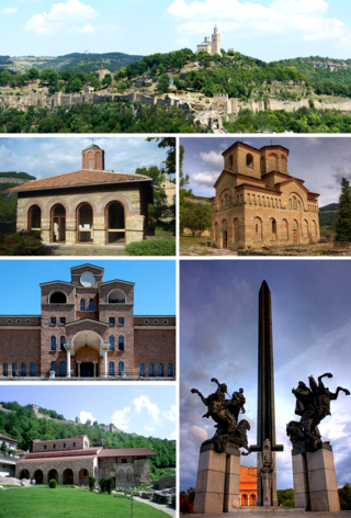
Veliko Tarnovo is a city in north central Bulgaria and the administrative centre of Veliko Tarnovo Province. It is the historical and cultural capital of Bulgaria.

<span class="mw-page-title-main">Sopot, Plovdiv Province</span> Town in Plovdiv, Bulgaria

Sopot is a Bulgarian town situated in the fertile sub-Balkan mountain valley of Karlovo, immediately below the steep southern slopes of the Troyan Balkan Mountain. Sopot is part of Plovdiv Province and is the administrative centre of a municipality with the same name.

<span class="mw-page-title-main">Sevlievo</span> Place in Gabrovo, Bulgaria

Sevlievo is a town in north-central Bulgaria, part of Gabrovo Province. Sevlievo is known as one of the wealthiest towns in Bulgaria owing to the well developed local economy, high employment rate and major foreign investments, such as the Ideal Standard Companies factory. It is the administrative centre of the homonymous Sevlievo Municipality.

<span class="mw-page-title-main">Dimitrovgrad, Bulgaria</span> Place in Haskovo, Bulgaria

Dimitrovgrad is a town in Haskovo Province, Bulgaria. It is along the Maritsa River in the Thrace region, close to the provincial capital, Haskovo. Dimitrovgrad is the administrative centre of Dimitrovgrad Municipality.

<span class="mw-page-title-main">Troyan</span> Place in Lovech, Bulgaria

Troyan is a town remembering the name of Roman Emperor Trajan, in Lovech Province in central Bulgaria. It is the administrative centre of the homonymous Troyan Municipality. The town is about 162 kilometres away from the country capital Sofia. The river of Beli Osam passes through the heart of the town. The 2021 Census indicates that the population of the Trojan was 18,449 inhabitants. The ethnic distribution of the inhabitants is ethnic Bulgarians (87.29%), with minorities being Roma (1.23%) and Turks (1.03%). Donka Mihaylova of Bulgarian Socialist Party has been the town's mayor since 2011.

Balgarovo is a small town in southeastern Bulgaria. It is located in Burgas Municipality and is close to the town of Kameno.

<span class="mw-page-title-main">Karnobat</span> Town in Burgas, Bulgaria

Karnobat is a town in the Burgas Province, Southeastern Bulgaria. It is the administrative centre of the homonymous Karnobat Municipality. According to the 2021 census, the town had a population of 16,483.

<span class="mw-page-title-main">Lovech</span> Place in Bulgaria

Lovech is a city in north-central Bulgaria. It is the administrative centre of the Lovech Province and of the subordinate Lovech Municipality. The city is located about 150 kilometres northeast from the capital city of Sofia. Near Lovech are the towns of Pleven, Troyan and Teteven.

<span class="mw-page-title-main">Karlovo</span> Town in Plovdiv, Bulgaria

Karlovo is a historically important town in central Bulgaria located in a fertile valley along the river Stryama at the southern foot of the Balkan Mountains. It is administratively part of Plovdiv Province and has a population of about 19,373, the mayor being Dr. Emil Kabaivanov.

<span class="mw-page-title-main">Velingrad</span> Town in Pazardzhik Province, Bulgaria

Velingrad is a town in Pazardzhik Province, Southern Bulgaria, located at the western end of Chepino Valley, part of the Rhodope Mountains. It is the administrative center of the homonymous Velingrad Municipality and one of the most popular Bulgarian balneological resorts. The town has a population of 22,602 inhabitants according to the 2011 census of Velingrad.

<span class="mw-page-title-main">Teteven</span> Place in Lovech, Bulgaria

Teteven is a town on the banks of the Vit, at the foot of the Balkan mountains in north central Bulgaria. It is the administrative centre of the Teteven Municipality which is a part of Lovech Province. As of December 2010, the town had a population of 10,733.

<span class="mw-page-title-main">Levski, Pleven Province</span> Town in Pleven, Bulgaria

Levski is a town in central northern Bulgaria, an administrative center of the homonymous Levski Municipality in the very southeast of Pleven Province.

100 Tourist Sites of Bulgaria is a Bulgarian national movement established in 1966 to promote tourism among Bulgaria's most significant cultural, historic, and natural landmarks.

<span class="mw-page-title-main">Pavel Banya</span>

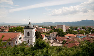
Pavel Banya is a small town in Stara Zagora Province, South-central Bulgaria, located between the towns of Kalofer and Kazanlak. It is the administrative centre of the homonymous Pavel Banya Municipality. As of December 2009, the town had a population of 2,918. The place is famous for its mineral springs.

<span class="mw-page-title-main">Štalkovica</span> Village in Eastern, North Macedonia

Štalkovica is a village in the municipality of Probištip, North Macedonia. It used to be part of the former municipality of Zletovo.

<span class="mw-page-title-main">Mijaks</span> Ethnographic group of North Macedonia

Mijaks are an ethnographic group of Macedonians who live in the Lower Reka region which is also known as Mijačija, along the Radika river, in western North Macedonia, numbering 30,000–60,000 people. The Mijaks practise predominantly animal husbandry, and are known for their ecclesiastical architecture, woodworking, iconography, and other rich traditions, as well as their characteristic Galičnik dialect of Macedonian. The main settlement of the Mijaks is Galičnik.

Izvor is a village in Burgas Municipality, in Burgas Province, in southeastern Bulgaria. It is known for the long stay of Bulgarian revolutionary Vasil Levski during the preparation of an uprising against the Ottoman Empire.

<span class="mw-page-title-main">Bust of Vasil Levski</span> Sculpture in Washington, D.C., U.S.

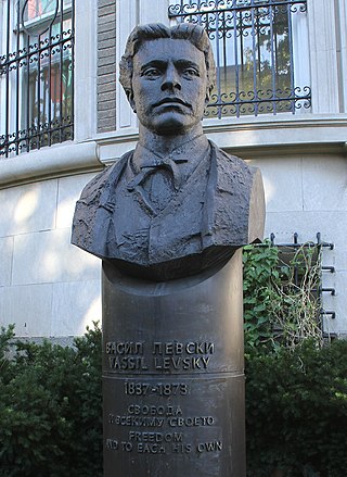
A bust of Vasil Levski is installed outside the Embassy of Bulgaria, near Sheridan Circle, along Embassy Row and in the Kalorama Heights neighborhood of Washington, D.C., United States.

The Aytoska reka is a 32.5 km long river in eastern Bulgaria that flows into Lake Burgas, which drains into the Black Sea.

<span class="mw-page-title-main">FC Vihar</span> Football club

„Vihar“ Football Club is a bulgarian football club based inAytos. The club was established in 1921 and plays in the "A" Regional Group Burgas.

References

  1. 1 2 3 "Население по области, общини, местоживеене и пол | Национален статистически институт". nsi.bg. Retrieved 3 January 2024.
  2. Климатични данни за избрани български станции (1961-1990г., "Месечен бюлетин на НИМХ"+), Stringmeteo.com (in Bulgarian) Retrieved February 23, 2012.

42°42′N27°15′E / 42.700°N 27.250°E / 42.700; 27.250