The municipality of Razlog comprises the villages of Banya, Gorno Draglishte, Dolno Draglishte, Dobarsko, Bachevo, Godlevo, and Eleshnitsa with a total population of 20,410 inhabitants. Each has its own charm.
The fairy-tale village of Dobarsko, hidden in the outskirts of Rila, maintains the legends of the Dobarsko Singing School. One can see here the church "Saints Theodor Tiron and Theodor Stratilat" (1614) — a National Monument of Culture with high architectural and artistic culture. The murals depicting Jesus Christ in what observers claim to be a jet rocket astonishes foreigners as well as Bulgarians. The icons in the Tzar (King) Row of church "Sretenie Gospodne" (1860) were painted by Simeon D. Molerov, a representative of the Bansko Painting School.
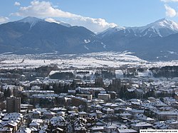
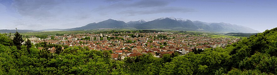
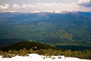
View over Razlog with the mountains in the background
History
During his 1894–1896 trip in the region of Macedonia, Bulgarian geographer Vasil Kanchov visited Razlog (then known as Мехомия, Mehomiya) and reported that it numbered 820 households, of which 500 of Eastern OrthodoxBulgarians, 300 of Muslim Bulgarians (Pomaks), 16 of Protestant Bulgarians and 5 of Eastern Orthodox Aromanians, for a total population of around 4,620.[1] According to the same author's 1900 study on the population of Macedonia, Razlog was populated by 4,970 people, of which 3,200 Christian Bulgarians, 1,460 Muslim Bulgarians, 80 Turks, 200 Romani and 30 Aromanians.[2]
In 1925, the town was renamed from Mehomia to Razlog.
The municipality of Razlog and the whole Razlog valley possess rich inheritance of cultural monuments from different ages and civilizations. There are seven cultural monuments in the territory of Razlog. These are the Christian temples: Saint Georgi Pobedonoset (built in 1834 in Razlog); Saint Gerogii (built in 1834 in Banya village); Uspenie Bogorodichno (built in 1835 in Dolno Draglishte village) — the iconostasis in this temple was made by one of the most prominent representatives of the wood-carving school in Tryavna: Dosyu Koyuv; Saint Bogoroditsa in Dolno Draglishte village, specialists suppose that the temple was built before the 16th century; Sretenie Gospodne (built in 1860 in Dobarsko village); and Saint Theodor Тiron and Theodor Stratilat (built in 1614 in Dobarsko village). This temple has unique mural paintings; it is a cultural monument under the protection of UNESCO.
There are 70 houses in the municipality, which are archeological monuments. They are mainly from the age of the Revival — the so-called "Razlog-Chepino" houses.
The historic museum in Razlog presents a collection of pottery from the 19-20th century, local traditional hand-made textiles and bell-mouldings.
During the Second Balkan War (1913), the area around the town was a major battlefield between the Greek and Bulgarian armies. The town was captured by the Greek forces on 9 July (O.S.), recaptured by the Bulgarians on 16 July, and again to the Greeks on 18 July.[3] After the following peace treaty Razlog was ceded to Bulgaria.
Razlog developed as a centre of winter tourism in the 1990s and 2000s owing to its favourable position in the vicinity of the Pirin, Rila and Rhodope mountains.
Culture
Kukeri: New Year Carnival in Razlog
Razlog is a town with rich cultural traditions and customs kept through the centuries with the spirit of original Bulgarian values.[original research?]
Two of the most significant folklore events in Bulgaria[citation needed][4] are organized and held in Razlog. These are the New Year's Kukeri holidays and the gathering for folk art "Pirin sings".
Proof for the original kukeri traditions is the insignia of honour, given to the municipality of Razlog by Henri Van der Kroon, president of the International Federation of European and Mediterranean carnival towns in May 2004. As a member of this federation, the kukeri groups from the municipality of Razlog regularly participate in the events organised by it.
Unique is the gathering for folk art "Pirin songs", which is visited on a mass scale and takes one of the leading positions in organization and artistic organization.[citation needed] The gathering in the "Yavorov" hut has become tradition in the recent years. The hut is one of the most visited locations in the Pirin mountain.[citation needed] It was built 72 years ago[when?] and during the summer season it turns out to be small for numerous tourists.[citation needed] Interests for the tourists are local "valevitsi, craftsmen's shops and culinary art of Razlog with the scent of the "kapama", "chumlek", "church's beans", "sugrena banitsa", etc. Of great interest[original research?] are also the Easter and Christmas holiday, religious and general life customs, such as Todor's day (horse race), Voditsi (celebration of Yordan's day with throwing of a cross into water), Grandmother's day, Proshki, etc.
Education and sports
A big part of the specialized schools in the region are in Razlog; they provide qualified labor for the sectors of the economy and development in the municipality.
The education network in the Municipality of Razlog comprises nine municipality schools, two of which are primary, six secondary, there is one school with special classes in English, Mathematics with German; there are also four national schools. Specialists in the field of business administration and management in hotels and culinary arts, electronics, transportation, and agriculture are prepared in the professional high school of tourism, the professional transport high school and professional mechanization and agriculture high school.
In 1999 "ASIX"-Razlog was established, a club for martial arts, in which about 60 children train actively. The members of this club have won many prizes from republican, Balkan and international tournaments. There were more than 30 medals from the republican tournament in Karate-do and Ju-jitsu in 2006.
Other sports developed in the municipality are volleyball, football, taekwondo, chess and sport orientation. The most developed sport in the town is volleyball. The local team Pirin (Razlog) is among the best teams in the elite volleyball division in Bulgaria and often produces players for the national volleyball teams of the country. The football team has achieved good results for the last several years and now it is taking part in the second professional division in Bulgaria.
Nature
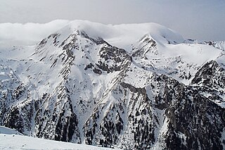
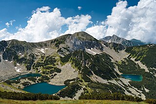
Nature is the greatest asset of Razlog valley. North of the town is the kingdom of the Rila National Park. Pirin rises to the south — the mountain that Slavs called "Mountain of Gods" (Perun). The Pirin National Park is included in the convention for the Preservation of World Natural and Cultural Heritage Sites. In Pirin, there are more than 100 bird species and over 1100 plant species among which is the symbol of the mountain: the edelweiss. There are 42 mammal species: chamois, bears and others.
The most precious parts of Pirin are designated reserves. "Bayuvi Dupki - Djinjiritsa" is a biosphere reserve under the auspices of UNESCO, where unique formations of white and Macedonian and Bosnian pine trees are to be found, together with more than 27 Bulgarian and 43 Balkan relict species.
Investments
In recent years[when?] the municipality of Razlog has attracted foreign investment, connected to the development of modern technologies in the fields of machine-building, electronics, and furniture production.[citation needed]
For the period 2005-2006 projects for near 50 million levs were implemented, and the investments applied for the beginning of 2006 were 100 million euro. The biggest private sites are the resort complex "Katarino SPA", "Hotel Razlog" with total investment of near 15 million euro. Of the foreign investments, the biggest are cleaning station for waste water for 6 million euro and road II-19 "Simitli-Razlog-Sadovo" which connects Bulgaria and Greece for 20 million euro.
The Pirin Golf & Country Club complex is in the Betolovoto location, at the foot of the Pirin mountain, with views to the Rila and Rodopi mountains. Besides the golf course with 18 holes and service buildings, the complex includes construction of a "Welcome zone" with car park, residential zone, center (commercial center, restaurants, cafes), horse base, and sports complex.[citation needed]
Imminent[when?] is the realization of a project including completion of ski-zone "Kulinoto", building of water park and other concomitant structures.
At the moment[when?] there are perspective researches for supplying Bansko, Razlog, Dobrinishte village and Banya village with natural gas, after which the construction of gas-conveying and distributing networks may begin in the locations foreseen for gasification.
Twin towns
Pineto, Italy (since 2016 in the frameworks of the SISTERS Twinning project)
Šibenik, Croatia (since 2016 in the frameworks of the SISTERS Twinning project)
Blagoevgrad is а town in Southwestern Bulgaria, the administrative centre of Blagoevgrad Municipality and of Blagoevgrad Province. With a population of almost 70,000 inhabitants, it is the economic and cultural centre of Southwestern Bulgaria. It is located in the valley of the Struma River at the foot of the Rila Mountains, 101 kilometres south of Sofia, close to the border with North Macedonia.
Blagoevgrad Province, also known as Pirin Macedonia or Bulgarian Macedonia, is a province (oblast) of southwestern Bulgaria. It borders four other Bulgarian provinces to the north and east, the Greek region of Macedonia to the south, and North Macedonia to the west. The province has 14 municipalities with 12 towns. Its principal city is Blagoevgrad, while other significant towns include Bansko, Gotse Delchev, Melnik, Petrich, Razlog, Sandanski, and Simitli.
Bansko is a town in southwestern Bulgaria, located in Blagoevgrad Oblast near the city of Razlog. Once mainly a stockbreeding and travelling merchant community, the town is now an international centre for winter and summer tourism. More recently Bansko has become a known hotspot for digital nomads driven in part by the relative affordability of the location combined with its natural scenery.
Rila is the highest mountain range of Bulgaria, the Balkan Peninsula, and Southeast Europe. It is situated in southwestern Bulgaria and forms part of the Rila–Rhodope Massif. The highest summit is Musala at an elevation of 2,925 m which makes Rila the sixth highest mountain range in Europe after the Caucasus, the Alps, Sierra Nevada, the Pyrenees and Mount Etna, and the highest one between the Alps and the Caucasus. It spans a territory of 2,629 km2 with an average elevation of 1487 m. The mountain is believed to have been named after the river of the same name, which comes from the Old Bulgarian verb "рыти" meaning "to grub".
The Pirin Mountains are a mountain range in southwestern Bulgaria, with the highest peak, Vihren, at an altitude of 2,914 m (9,560 ft).
Simitli also known as Simitliya, is a town in Blagoevgrad Province in southwestern Bulgaria. It has a population of 7,454 and is located 17 km south of Blagoevgrad. It is the seat of Simitli Municipality.
Pirin National Park, originally named Vihren National Park, encompasses the larger part of the Pirin Mountains in southwestern Bulgaria, spanning an area of 403.56 square kilometers (155.82 sq mi).
Belitsa is a town in southwestern Bulgaria, located in the Belitsa Municipality of the province of Blagoevgrad.
The Razlog Valley is a valley in southwestern Bulgaria, Blagoevgrad Province, containing the Razlog, Bansko, and Belitsa municipalities. It is bounded by the Rila Mountains to the north and northwest, the Pirin Mountains to the south and southwest, and the Rhodope Mountains to the east. The transitional continental Mediterranean climate and nature of the valley are influenced by both the high alpine mountain “walls” of Rila and Pirin and the vast and wild Rhodopes, and the warm Mediterranean climate of the Aegean Sea entering from the south via the Mesta river course.
Dobarsko is a village in southwestern Bulgaria, part of Razlog Municipality, Blagoevgrad Province. It is set at 1,070 m above sea level on the southern slopes of Rila with the westernmost Rhodope Mountains to the east and Pirin to the south near the valley of the Mesta River. Dobarsko is 80 km from Blagoevgrad and 17 km from the winter resort Bansko. As of September 2005 the village has a population of 672 and about 200 houses, the mayor being Nikola Naydenov.
100 Tourist Sites of Bulgaria is a Bulgarian national movement established in 1966 to promote tourism among Bulgaria's most significant cultural, historic, and natural landmarks.
Dobrinishte is a small town and ski resort in the Blagoevgrad Province, Bansko Municipality, southwestern Bulgaria. As of 2006 it had 2973 inhabitants. It is located 6 km east of Bansko, a famous winter resort. It has an altitude of 850 m and is surrounded by the Rila, Pirin, and Rhodope mountains. Dobrinishte offers good conditions for both winter and summer tourism: beautiful nature, hospitable population, ski runs, mineral waters and opportunities for rural and ecotourism. According to legends and song, between 6th and 15th century Dobrinishte was a Bulgarian stronghold which halted the Byzantines from invading the country from the valley of the Mesta River.
Kresna is a town and the seat of Kresna Municipality in Blagoevgrad Province in Bulgaria.
Banya is a village in Razlog Municipality, in Blagoevgrad Province, Bulgaria, laying 4 km to the east of the town of Razlog and at about the same distance to the north of the ski resort of Bansko.
Gorno Draglishte is a village in Razlog Municipality, in Blagoevgrad Province, Bulgaria.
The Septemvri–Dobrinishte narrow-gauge line is the only operating 760 mm narrow-gauge line in Bulgaria. It is operated by Bulgarian State Railways (BDŽ). The line is actively used with four passenger trains running the length of the line in each direction per day. The journey takes five hours through the valleys and gorges between the mountain ranges of Rila, Pirin and Rhodopes.
Belitsa Municipality is located in the southwestern part of Bulgaria in the northeastern part of the Blagoevgrad Province. The administrative center is the town of Belitsa and there are also 11 villages and the ski resort Semkovo.
Predel is a mountain saddle (pass) in western Bulgaria between the mountain ranges of Rila to the north and Pirin to the south. It is situated on the territory of the Simitli and Razlog municipalities in Blagoevgrad Province.
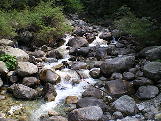
The Glazne is a river in south-western Bulgaria, a right tributary of the Iztok, itself a right tributary of the river Mesta. The river is 11 km long and drains parts of the northeastern slopes of the Pirin mountain range.
Republican Road II-19 is a second class road in Blagoevgrad Province, southwestern Bulgaria. Its length is 109.7 km.
This page is based on this Wikipedia article Text is available under the CC BY-SA 4.0 license; additional terms may apply. Images, videos and audio are available under their respective licenses.