Azam Warsak

Last updated
Azam Warsak
اعظم ورسک
Mjkhanwazir01.jpg
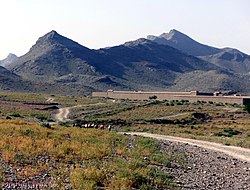
Dramatic scenery of Azam Warsak
Pakistan Khyber Pakhtunkhwa location map.svg
Red pog.svg
Azam Warsak
Pakistan location map.svg
Red pog.svg
Azam Warsak
Coordinates: 32°17′15.8″N69°24′49.5″E / 32.287722°N 69.413750°E / 32.287722; 69.413750
CountryFlag of Pakistan.svg Pakistan
Province PK-NWFP.svg Khyber Pakhtunkhwa
District South Waziristan
Tehsil Birmal Tehsil
Elevation
1,387 m (4,551 ft)
Time zone UTC+5 (PST)
[1]

Azam Warsak is a village located in Birmil Tehsil in the Lower South Waziristan District of Khyber Pakhtunkhwa province, Pakistan. It is located approximately 20 kilometres west of the town of Wanna. [2] [3] The village lies in area that is prone to cold weather in the winter. [4]

Contents

Latitude:32° 17' 15" N
Longitude:69° 24' 49" E
Lat/Long (dec):32.28772,69.41375

Militancy

See also

References

  1. "Map of Azam Warsak in Federally Administered Tribal Areas, Pakistan". Archived from the original on 10 October 2020. Retrieved 9 October 2020.
  2. "NA-50 South Waziristan Agency Area, Map, Candidates and Result". Political, Sports Workers Helpline. Archived from the original on 7 October 2020. Retrieved 7 October 2020.
  3. "How far is Azam Warsak from Wana". Distance Calculator. Archived from the original on 9 October 2020. Retrieved 9 October 2020.
  4. All work, some play: It’s not always sunny in Wana
  5. Six killed in missile attack in SW Pakistan
  6. CIA drone attack kills four in South Waziristan
  7. Drone Kills Top Taliban Commander Maulvi Nazir
  8. One Person Killed In Armed Attack On Pakistan Girls' School
  9. Assailants target school in SW, no loss of life
  10. Blasts destroy school and bridge in Waziristan
  11. JUI-F leader survives IED blast in South Waziristan