
Hadsel is a municipality in Nordland county, Norway. It is part of the traditional district of Vesterålen. The administrative centre of the municipality is the town of Stokmarknes. Other villages in Hadsel include Fiskebøl, Gjerstad, Grønning, Grytting, Hanøyvika, Hennes, Kaljord, Melbu, Sanden, and Sandnes.
Bø may refer to the following:
Bø is a municipality in Nordland county, Norway. It is part of the Vesterålen region. The administrative centre of the municipality is the village of Straume. Other villages in the municipality include Auvåg, the village of Bø, Eidet, Guvåg, Hovden, Klakksjorda, Malnes, Nykvåg, Utskor, and Vågen. The Litløy Lighthouse is located on the tiny island of Litløya off the coast of Bø.

Øksnes is a municipality in Nordland county, Norway. It is located on the northwestern part of the large island of Langøya, which is a part of the traditional region of Vesterålen. The administrative centre of the municipality is the village of Myre. Other villages in Øksnes include Alsvåg, Barkestad, Breidstrand, Nyksund, Strengelvåg, and Stø.

Vesterålen is a district and archipelago in Nordland county, Norway. It is located just north of the Lofoten district and archipelago and west of the town of Harstad. It is the northernmost part of Nordland county, including the municipalities of Andøy, Bø, Hadsel, Sortland, and Øksnes.

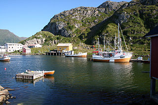
Straume is the administrative centre of Bø Municipality in Nordland county, Norway. The village is located on the island of Langøya in the Vesterålen archipelago. The village is located about 10 kilometres (6.2 mi) from the village of Bø and the village of Eidet, in the west central part of the municipality.

Liland is a village in Sortland Municipality in Nordland county, Norway. The village is located on the island of Hinnøya along the Sortlandssundet strait, about 10 kilometres (6.2 mi) northeast of the town of Sortland, and just north of the Kvalsaukan Bridge.

Sigerfjord is a village in Sortland Municipality in Nordland county, Norway. The village is located on the island of Hinnøya by the entrance to the Sigerfjorden. The village of Strand and the Sortland Bridge are located about 6 kilometres (3.7 mi) to the north. Sigerfjord Church is located in this village.
Strand is a village in Sortland Municipality in Nordland county, Norway. The village is located on the island of Hinnøya at the eastern end of the Sortland Bridge which crosses the Sortlandsundet strait and connects to the town of Sortland on Langøya island. It is located about 5 kilometres (3.1 mi) north of the village of Sigerfjord.
Holand is a village in Sortland Municipality in Nordland county, Norway. The village is located on the island of Langøya along the Sortlandssundet strait, about 10 kilometres (6.2 mi) southwest of the town of Sortland and about 4 kilometres (2.5 mi) southwest of the village of Bø.

Langøya is the third largest island of Norway, with an area of 850.2 square kilometres (328.3 sq mi). The island is a part of the Vesterålen archipelago in Nordland county, Norway. The island includes the municipalities of Bø and Øksnes as well as parts of the municipalities of Sortland and Hadsel.

Forfjorden is a fjord on the west side of the island of Hinnøya in the Vesterålen archipelago in Nordland county, Norway. The fjord lies along the border between Sortland Municipality and Andøy Municipality. The Norwegian County Road 82 follows the shoreline around the whole fjord. The coast around the Forfjorden has about 70 inhabitants. The fjord is located about 30 kilometres (19 mi) northeast of the town of Sortland and about 70 kilometres (43 mi) south of Andenes. The name is derived from its surrounding pine forest, as "Furu" and "Forra" translates to pine tree. The 7-kilometre (4.3 mi) long fjord flows to the west and joins the Gavlfjorden along with the Risøysundet and Sortlandssundet straits.
Holmstad is a village in Sortland Municipality in Nordland county, Norway. The village is located along the Eidsfjorden on the island of Langøya, about 12 kilometres (7.5 mi) west of the town of Sortland. Indre Eidsfjord Church is located in this village.

Eidsfjorden is a fjord in Nordland county, Norway. The 25-kilometre (16 mi) long fjord cuts into the island of Langøya in the Vesterålen archipelago and it is located in the municipalities of Bø, Hadsel, and Sortland. It branches off of the main Vesterålsfjorden which is part of Norwegian Sea. The innermost part of the fjord is part of Sortland Municipality. The outer part of the fjord is split with the western coast belonging to Bø Municipality and the eastern coast belonging to Hadsel Municipality.
Hellfjorden is a fjord in Nordland county, Norway. The 6.5-kilometre (4.0 mi) long fjord is an arm off of the main Eidsfjorden and the border between Sortland Municipality and Bø Municipality runs right down the middle of the fjord. The narrow fjord cuts into the large island of Langøya in the Vesterålen archipelago. The fjord lies in a very rugged, sparsely populated area.

County Road 820 is a 73.1-kilometer (45.4 mi) road in the municipalities of Bø, Øksnes, and Sortland in Nordland County, Norway. It starts in the village of Straumsnes in the municipality of Bø, where it continues south from County Road 901, circles around the west end of the island of Langøya through the Straume Nature Reserve to the village of Straume, and continues east to the Ryggedal Tunnel. It then passes through the municipality of Øksnes along the west shore of Ånnfjord and south shore of Skjellfjord before entering the municipality of Sortland. There it passes along the inner shore of Eidsfjord through Frøskeland, crosses Vikeid, where County Road 956 branches off to Vik, and then runs past the southwest shore of the Vikosen Nature Reserve and along the west side of Sortlandssundet strait, where it terminates at the town of Sortland.

Frøskeland is a village in Sortland Municipality in Nordland county, Norway.
Vik is a village in Sortland Municipality in Nordland county, Norway. The village is located on the island of Langøya, about 13 kilometers (8.1 mi) north of the town of Sortland.

Sortland (help·info) is a town and the administrative centre of Sortland Municipality in Nordland county, Norway. The town is located on the east coast of the island of Langøya, along the Sortlandsundet strait. In 1997, the municipality decided to declare "town status" for the urban area of Sortland. Sortland is the largest town and commercial centre in the whole Vesterålen region and it is becoming known as "the blue town by the strait" since many of the buildings are painted blue.


