
Sortland (Norwegian) or Suortá (Northern Sami) is a municipality in Nordland county, Norway. It is part of the traditional region of Vesterålen. The administrative centre of the municipality is the town of Sortland. Other population centres in Sortland include Bø, Holand, Holmstad, Liland, Sigerfjord, Strand, and Vik. The Norwegian Coast Guard has its northern base in Sortland, called Kystvaktskvadron Nord.

Vesterålen is a district and archipelago in Nordland county, Norway. It is located just north of the Lofoten district and archipelago and west of the town of Harstad. It is the northernmost part of Nordland county, including the municipalities of Andøy, Bø, Hadsel, Sortland, and Øksnes.

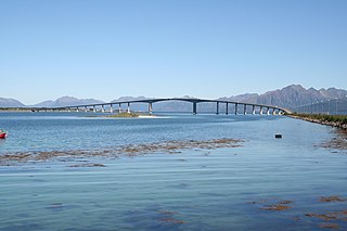
The Sortland Bridge is a cantilever road bridge that crosses the Sortlandssundet strait between the village of Strand on Hinnøya island and the town of Sortland on Langøya island. It is located within Sortland Municipality in Nordland county, Norway. The bridge is 948 metres (3,110 ft) long, the main span is 150 metres (490 ft), and the maximum clearance to the sea is 30 metres (98 ft). The bridge has 21 spans.
The Hadsel Bridge is a cantilever road bridge in Hadsel Municipality in Nordland county, Norway. The bridge carries Norwegian County Road 82 and it crosses the Langøysundet strait between the islands of Langøya and Børøya. Together with the Børøy Bridge it connects the island of Hadseløya and the town of Stokmarknes to the neighboring island of Langøya. The Hadsel Bridge is 1,011 metres (3,317 ft) long, the main span is 150 metres (490 ft), and the maximum clearance to the sea is 30 metres (98 ft). The bridge has a total of 27 spans.
Theodor Kjerulf was a Norwegian geologist and professor at the University of Oslo. He also served as director of the Norwegian Geological Survey.

Liland is a village in Sortland Municipality in Nordland county, Norway. The village is located on the island of Hinnøya along the Sortlandssundet strait, about 10 kilometres (6.2 mi) northeast of the town of Sortland, and just north of the Kvalsaukan Bridge.
Holand is a village in Sortland Municipality in Nordland county, Norway. The village is located on the island of Langøya along the Sortlandssundet strait, about 10 kilometres (6.2 mi) southwest of the town of Sortland and about 4 kilometres (2.5 mi) southwest of the village of Bø.
Bø is a village in Sortland Municipality in Nordland county, Norway. The village is located on the island of Langøya along the Sortlandssundet strait, about 6 kilometres (3.7 mi) southwest of the town of Sortland and about 4 kilometres (2.5 mi) northeast of the village of Holand.

Prof Olaf Holtedahl ForMemRS FRSE was a Norwegian geologist. He became a senior lecturer at the University of Oslo in 1914, and was Professor of Geology there from 1920 to 1956.

Langøya is the third largest island of Norway, with an area of 850.2 square kilometres (328.3 sq mi). The island is a part of the Vesterålen archipelago in Nordland county, Norway. The island includes the municipalities of Bø and Øksnes as well as parts of the municipalities of Sortland and Hadsel.

Geological Survey of Norway, abbr: NGU is a Norwegian government agency responsible for geologic mapping and research. The agency is located in Trondheim with an office in Tromsø, with about 200 employees. It is subordinate to the Norwegian Ministry of Trade, Industry and Fisheries.

Hårek Elvenes is a Norwegian politician for the Conservative Party.

Werner Werenskiold was a Norwegian geologist and geographer. He was a son of Erik Werenskiold and visual artist Sophie Marie Stoltenberg Thomesen (1849–1926), and the brother of Dagfin Werenskiold.
Arendalsfeltet is a geologic province in Norway, between Fevik and Tvedestrand in the county of Aust-Agder, mainly situated within the borders of Arendal. Arendalsfeltet is especially known for its deposits of iron ore.

Gavlfjorden is a fjord in Nordland county, Norway. The 20-kilometre (12 mi) long fjord separates the large islands of Langøya and Andøya in the Vesterålen archipelago and it runs along the border of three municipalities: Øksnes, Andøy, and Sortland. In the north, the fjord flows out into the Norwegian Sea, and in the south, the fjord splits into the Sortlandssundet strait and the Risøysundet strait.

Risøysundet is a strait between the islands of Andøya and Hinnøya in the Vesterålen archipelago in Norway. It is located in Andøy Municipality in Nordland county. The 24-kilometre (15 mi) long strait has only one road crossing: the Andøy Bridge as part of the Norwegian County Road 82 connecting the villages of Risøyhamn and Dragnes.
Saksenvik is a basic statistical unit in the Nedre Saltdal subarea of the municipality of Saltdal in Nordland county, Norway. European route E6 passes through Saksenvik, part of the way via the Saksenvik Tunnel. Since 2012, the Saksenvik Hydroelectric Power Station has produced electricity in the region.
Jakobsbakken is a clustered settlement in the municipality of Fauske in Nordland, Norway. It is situated south of Lake Langvatnet in Sulitjelma, just above the tree line at an elevation of 600 meters (2,000 ft).

County Road 820 is a 73.1-kilometer (45.4 mi) road in the municipalities of Bø, Øksnes, and Sortland in Nordland County, Norway. It starts in the village of Straumsnes in the municipality of Bø, where it continues south from County Road 901, circles around the west end of the island of Langøya through the Straume Nature Reserve to the village of Straume, and continues east to the Ryggedal Tunnel. It then passes through the municipality of Øksnes along the west shore of Ånnfjord and south shore of Skjellfjord before entering the municipality of Sortland. There it passes along the inner shore of Eidsfjord through Frøskeland, crosses Vikeid, where County Road 956 branches off to Vik, and then runs past the southwest shore of the Vikosen Nature Reserve and along the west side of Sortlandssundet strait, where it terminates at the town of Sortland.

Sortland (help·info) is a town and the administrative centre of Sortland Municipality in Nordland county, Norway. The town is located on the east coast of the island of Langøya, along the Sortlandsundet strait. In 1997, the municipality decided to declare "town status" for the urban area of Sortland. Sortland is the largest town and commercial centre in the whole Vesterålen region and it is becoming known as "the blue town by the strait" since many of the buildings are painted blue.


