
The Oslofjord is an inlet in the south-east of Norway, stretching from an imaginary line between the Torbjørnskjær and Færder lighthouses and down to Langesund in the south to Oslo in the north. It is part of the Skagerrak strait, connecting the North Sea and the Kattegat sea area, which leads to the Baltic Sea. The Oslofjord is not a fjord in the geological sense — in Norwegian the term fjord can refer to a wide range of waterways. The bay is divided into the inner and outer Oslofjord at the point of the 17 by 1 kilometre Drøbak Sound.

Saltstraumen is a small strait with one of the strongest tidal currents in the world. It is located in the municipality of Bodø in Nordland county, Norway. It is located about 10 kilometres (6.2 mi) southeast of the town of Bodø. The narrow channel connects the outer Saltfjorden to the large Skjerstad Fjord between the islands of Straumøya and Knaplundsøya. The Saltstraumen Bridge on Norwegian County Road 17 crosses Saltstraumen.

The Trondheim Fjord or Trondheimsfjorden, an inlet of the Norwegian Sea, is Norway's third-longest fjord at 130 kilometres (81 mi) long. It is located in the west-central part of the country in Trøndelag county, and it stretches from the municipality of Ørland in the west to the municipality of Steinkjer in the north, passing the city of Trondheim on its way. Its maximum depth is 617 metres (2,024 ft), between Agdenes and Indre Fosen.

The Danish straits are the straits connecting the Baltic Sea to the North Sea through the Kattegat and Skagerrak. Historically, the Danish straits were internal waterways of Denmark; however, following territorial losses, Øresund and Fehmarn Belt are now shared with Sweden and Germany, while the Great Belt and the Little Belt have remained Danish territorial waters. The Copenhagen Convention of 1857 made all the Danish straits an international waterway.
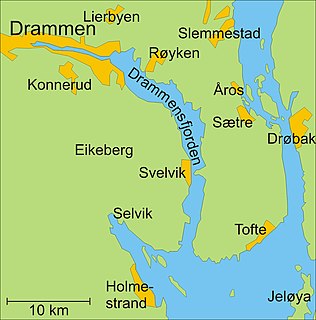
Drammensfjord is a fjord in Norway that connects to Ytre Oslofjord on the west side. It stretches to the north and northeast. The Drammenselva river discharges into the head of the fjord. The municipality and city of Drammen which is named after the fjord is also found there.

Wahlenbergfjorden, sometimes known in English as Waalenburg Bay, is a fjord on the southwest coast of the Arctic island of Nordaustlandet, in Norway's Svalbard archipelago. At 46 kilometres (29 mi) in length, and 15 km (9.3 mi) wide, it is the fifth longest fjord in the archipelago, and the longest on the island. The fjord lies between Gustav V Land and Gustav Adolf Land, at geographical co-ordinates 79°40′N20°00′E. Its mouth faces Spitsbergen across Hinlopen Strait, the strait separating the two islands.
Hadselfjorden or Hadselfjord is a fjord in Hadsel Municipality in Nordland county, Norway. The fjord lies in the Vesterålen region, separating the island of Hadseløya from the islands of Austvågøya and Hinnøya island. In the northeast, the Hadselfjorden connects with Sortlandssund strait, which separates the islands of Langøya and Hinnøya. In the southwest the fjord empties into the Norwegian Sea.

Kangerlussuaq Fjord is a long fjord in the Qeqqata municipality in central-western Greenland. The fjord is 190 km (120 mi) long and between 1.5 km (0.93 mi) and 8 km (5.0 mi) wide, flowing from the estuary of Qinnguata Kuussua river to the southwest, and emptying into the Davis Strait. It is the longest fjord of western Greenland.
Beitstadfjorden is the innermost arm of the Trondheimsfjord in Trøndelag county, Norway. It is located in the municipalities of Steinkjer, Inderøy, and Verran. The fjord has a length of 28 kilometres (17 mi) from southwest to northeast, and a width of about 6 to 8 kilometres.

Selbjørnsfjorden is a fjord in Hordaland county, Norway. The 20-kilometre (12 mi) long fjord flows east-west between the municipalities of Austevoll, Fitjar, and Bømlo. It is a wide fjord that starts at the Slåtterøy Lighthouse at the North Sea in the west and flows to the strait of Langenuen in the east. The central part of the fjord reaches about 8 kilometres (5.0 mi) wide. The fjord is named after the nearby island of Selbjørn.

Saltfjorden or Saltenfjorden is a fjord in the municipalities of Bodø and Gildeskål in Nordland county, Norway. The 40-kilometre (25 mi) long fjord begins around the Fleinvær islands; travels northeast past the islands of Sørarnøya, Sandhornøya, and Straumøya islands; along the southern shores of the town of Bodø; and ends at the village of Løding.
Skjerstad Fjord is a fjord in the municipalities of Bodø, Fauske, and Saltdal in Nordland county, Norway. It is a 40-kilometre (25 mi) long arm off of the main Saltfjorden. It is connected to the Saltfjorden by the narrow Saltstraumen strait, which has very strong tidal currents. The villages of Valnesfjord and Rognan and the town of Fauske lie along the shores of the fjord. European route E06 runs along the eastern shore of the fjord, and the Nordland Line follows the eastern and northern shores of the fjord. The Misværfjorden branches off this fjord to the south at the village of Skjerstad.

Risøysundet is a strait between the islands of Andøya and Hinnøya in the Vesterålen archipelago in Norway. It is located in Andøy Municipality in Nordland county. The 24-kilometre (15 mi) long strait has only one road crossing: the Andøy Bridge as part of the Norwegian County Road 82 connecting the villages of Risøyhamn and Dragnes.

Astafjorden is a fjord in Troms county, Norway. It flows through the municipalities of Salangen, Gratangen, Ibestad, and Skånland. The 30-kilometre (19 mi) long fjord flows from the Salangen fjord in the east to the Vågsfjorden in the west. The 3.5-kilometre (2.2 mi) wide fjord separates the islands of Andørja and Rolla from the mainland. There are several small fjords that branch off this fjord including: Lavangen, Gratangen, Grovfjorden, and Salangen.
Balsfjorden (Norwegian) or Báhccavuotna (Northern Sami) is a fjord in Troms county, Norway. The 57-kilometre (35 mi) long fjord runs through the municipalities of Balsfjord and Tromsø. It branches off the Tromsøysundet strait just south of the city of Tromsø and it flows in a north-south direction, ranging from 2 to 7 kilometres wide. The European route E8 highway follows most of the eastern shore of the fjord and the European route E6 highway runs along the southern end of the fjord. The village of Storsteinnes lies along the southwestern coast of the fjord and the village of Nordkjosbotn lies at the southeastern end of the fjord.

Solbergfjorden is a fjord on the southeastern side of the large island of Senja in Troms county, Norway. It lies in the municipalities of Tranøy, Dyrøy, Sørreisa, and Lenvik. The 27-kilometre (17 mi) long strait flows into the Vågsfjorden to the southwest and into the Finnfjorden and Reisafjorden in the northeast. Vangsvik is one of the larger settlements along the Solbergfjorden.

Ullsfjorden (Norwegian) or Moskavuotna (Northern Sami) is a fjord in Troms county, Norway. The fjord runs through the municipalities of Tromsø, Karlsøy, and Lyngen. The 75-kilometre (47 mi) fjord flows from the village of Sjøvassbotn northwards along the west side of the Lyngen Peninsula. The Kjosen fjord branches off to the east side and the Grøtsundet strait branches off to the west. The islands of Reinøya and Karlsøya lie along the western side of the fjord. The southern part of the Ullsfjorden is also known as Sørfjorden. The area surrounding the Ullsfjorden was part of the municipality of Ullsfjord for about 60 years during the 20th century.

Vartdalsfjorden is a fjord in Møre og Romsdal county, Norway. It begins at the Storfjorden and Sulafjorden in the northeast and flows through Hareid Municipality and Ulstein Municipality on the northern shore of the fjord and through Ørsta Municipality and Volda Municipality on the southern shore. The 20-kilometre (12 mi) long fjord has one road crossing, the Eiksund Tunnel. The deepest part of the fjord reaches 365 metres (1,198 ft) below sea level. The village of Vartdal lies on the southern shore of the fjord in Ørsta Municipality. From 1895 until 1964, the southern banks of the fjord were part of Vartdal Municipality.

Sagfjorden (Norwegian) or Rivtakvuodna (Northern Sami) is a fjord in Nordland county, Norway. The 38-kilometre (24 mi) long fjord forms part of the boundary between the municipalities of Hamarøy and Steigen. There are several large islands in the fjord as well: Finnøya to the north and Lundøya and Engeløya at the mouth of the fjord where it joins the Vestfjorden.


