Related Research Articles
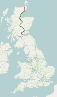
The A9 is a major road running from the Falkirk council area in central Scotland to Scrabster Harbour, Thurso in the far north, via Stirling, Bridge of Allan, Perth and Inverness. At 273 miles (439 km), it is the longest road in Scotland and the fifth-longest A-road in the United Kingdom. Historically it was the main road between Edinburgh and John o' Groats, and has been called the spine of Scotland.

The A38, parts of which are known as Devon Expressway, Bristol Road and Gloucester Road, is a major A-class trunk road in England.

The A44 is a major road in the United Kingdom that runs from Oxford in southern England to Aberystwyth in west Wales.

The A47 is a trunk road in England linking Birmingham to Lowestoft, Suffolk. Most of the section between Birmingham and Nuneaton is now classified as the B4114.

Alcester is a market town and civil parish of Roman origin at the junction of the River Alne and River Arrow in Warwickshire, England, approximately 8 miles (13 km) west of Stratford-upon-Avon, and 8 miles south of Redditch, close to the Worcestershire border. The 2011 census recorded a population of 6,273.

The A46 is a major A road in England. It starts east of Bath, Somerset and ends in Cleethorpes, Lincolnshire, but it does not form a continuous route. Large portions of the old road have been lost, bypassed, or replaced by motorway development. Between Leicester and Lincoln the road follows the course of the Roman Fosse Way, but between Bath and Leicester, two cities also linked by the Fosse Way, it follows a more westerly course.

The A24 is a major road in England that runs for 53.2 miles (85.6 km) from Clapham in south-west London to Worthing on the English Channel in West Sussex via the suburbs of south-west London, as well as through the counties of Surrey and West Sussex.
The A361 is a major road in England and at 195 miles (314 km) is the longest 3 digit A road in the UK. It runs south from Ilfracombe on the north Devon coast to Barnstaple, turning south-east to Tiverton then, after a break, north east from Taunton in Somerset through Street and Glastonbury, along the bottom of the Mendip Hills through Shepton Mallet, past Frome and then into Wiltshire through Trowbridge, Devizes, Avebury and Swindon. It then runs through the eastern Cotswolds, via Lechlade, Burford and Chipping Norton and on through Banbury and Daventry before terminating at its junction with the A5 road at the village of Kilsby on the Northamptonshire-Warwickshire border near Rugby. Despite its length, most of the road is non-primary and relatively unimportant.

The A217 is a road in London and Surrey in England. It runs north/south. It runs from Kings Road in Fulham, London, crosses the Thames at Wandsworth Bridge, then passes through Wandsworth, Earlsfield, Summerstown, Tooting, Mitcham, Rosehill and Sutton Common in Sutton, then Cheam. Then, widened as a dual carriageway, comes Belmont, a suburban district built on a slope rising southward. On the North Downs in Surrey the road then skirts past Banstead and through its late 19th century offspring villages particularly Burgh Heath and Kingswood, Surrey. It then crosses the M25 motorway at Junction 8, then, returning to single carriageways, passes through the castle town of Reigate. It then cuts through the green buffer farmland of two rural villages and terminates at the road network at Gatwick Airport's northern perimeter.

The A422 is an "A" road for east–west journeys in south central England, connecting the county towns of Bedford and Worcester by way of Milton Keynes, Buckingham, Banbury and Stratford-upon-Avon. For most of its length, it is a narrow single carriageway.

The A1079 is a major road in Northern England. It links the cities of York and Kingston upon Hull, both in Yorkshire.

The A338 is a major primary route in southern England, that runs from the junction with the A35 at Poole in Dorset to the junction with the A420 at Besselsleigh in Oxfordshire, a distance of 84 miles (135 km).

The A556 is a road in England which extends from the village of Delamere in Cheshire West and Chester to the Bowdon Interchange in Cheshire East, bordering Greater Manchester. The road contains a mixture of single and dual carriageway sections and forms a large part of the route between Manchester and Chester. It also acts as a major access route to Chester/North Wales to the west and to Manchester to the east for the conurbation of towns and villages around the Dane Valley centering on Winsford and Northwich. The central part, which forms the Northwich Bypass between Davenham and Lostock Gralam, suffers because of the amount of commuter traffic from this area. The part of the route between the M6 motorway Junction 19 and the M56 motorway Junction 7 is a major route into Manchester and has been recently upgraded to a four-lane dual carriageway.
The A140 is an 'A-class' road in Norfolk and Suffolk, East Anglia, England partly following the route of the Roman Pye Road. It runs from the A14 near Needham Market to the A149 south of Cromer. It is of primary status for the entirety of its route. It is approximately 56 miles (90 km) in length.

The A146 is an A road that connects Norwich in Norfolk and Lowestoft in Suffolk, two of East Anglia's largest population centres. It is around 27 miles (43 km) in length and has primary classification along its entire route. It is mainly single carriageway throughout its route, with the exception of a section of dual carriageway on the southern edge of Norwich.

Salford Priors is a rural, agricultural village and civil parish about four miles south-west of Alcester, Warwickshire, England. The population of the civil parish as taken at the 2011 census was 1,546. It is on the Warwickshire border with Worcestershire.

Cookhill is a village and civil parish in Worcestershire, England, on the county border near Alcester. It is close to a former Cistercian Priory of the same name.

Harvington is a village near Evesham in Worcestershire, England. Bounded by the River Avon to the south and the Lench Hills to the north, three miles northeast of Evesham and now on the Worcestershire/Warwickshire border. The village today is an amalgamation of two smaller villages, Harvington and Harvington Cross, and has a population of around 1750.

The A448 is a main road in England running between Studley in Warwickshire and Kidderminster in Worcestershire.
B4008 is a B road in Gloucestershire, England, which starts in Quedgeley and ends in Stroud. The road goes south from Quedgeley, passes near Hardwicke, intersects the M5 motorway at Junction 12, passes through Stonehouse, then turns east through the Ebley area before ending in Cainscross, Stroud. The road is 9.1 miles in length.
References
- ↑ "B4088 - Roader's Digest: The SABRE Wiki". www.sabre-roads.org.uk.
- ↑ "Google Maps". Google Maps.
- ↑ "Speed limits". GOV.UK.
| | This United Kingdom road or road transport-related article is a stub. You can help Wikipedia by expanding it. |