
Homestead is a city within Miami-Dade County in the U.S. state of Florida, between Biscayne National Park to the east and Everglades National Park to the west. Homestead is primarily a Miami suburb and a major agricultural area. It is a principal city of the Miami metropolitan area, which was home to an estimated 6,012,331 people at the 2015 census.

Federal Way is a city in King County, Washington, located within the Seattle metropolitan area. The population was 89,306 at the 2010 census and an estimated 96,289 in 2019. Federal Way is the tenth-largest city in Washington and the fifth-largest in King County, according to the Census Bureau's 2019 population estimate.

The Bonneville Power Administration (BPA) is an American federal agency operating in the Pacific Northwest. BPA was created by an act of Congress in 1937 to market electric power from the Bonneville Dam located on the Columbia River and to construct facilities necessary to transmit that power. Congress has since designated Bonneville to be the marketing agent for power from all of the federally owned hydroelectric projects in the Pacific Northwest. Bonneville is one of four regional Federal power marketing agencies within the U.S. Department of Energy (DOE).
M-1, commonly known as Woodward Avenue, is a north–south state trunkline highway in the Metro Detroit area of the US state of Michigan. The highway, called "Detroit's Main Street", runs from Detroit north-northwesterly to Pontiac. It is one of the five principal avenues of Detroit, along with Michigan, Grand River, Gratiot, and Jefferson avenues. These streets were platted in 1805 by Judge Augustus B. Woodward, namesake to Woodward Avenue. The Federal Highway Administration (FHWA) has listed the highway as the Automotive Heritage Trail, an All-American Road in the National Scenic Byways Program. It has also been designated a Pure Michigan Byway by the Michigan Department of Transportation (MDOT), and was also included in the MotorCities National Heritage Area designated by the US Congress in 1998.
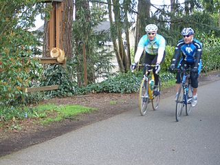
The Burke–Gilman Trail is a rail trail in King County, Washington. The 27-mile (43 km) multi-use recreational trail is part of the King County Regional Trail System and occupies an abandoned Seattle, Lake Shore and Eastern Railway corridor.
The Washington, Baltimore and Annapolis Trail (WB&A) is a 10.25-mile (16.50 km) long discontinuous rail trail from Lanham to Odenton in Maryland. Despite its name, it does not actually connect with Washington, D.C., Annapolis or Baltimore; its name is taken from the Washington, Baltimore and Annapolis Electric Railway, from which the right-of-way comes. The trail exists in two separate pieces, one in Anne Arundel County and the other in Prince George's County, separated by the lack of a bridge over the Patuxent River. The bridge's construction and the trail's alignment was delayed for over a decade due to a property dispute; however, the trail was realigned and plans exist to complete a bridge by 2021. Additional plans exist to extend the trail southward to the Washington, D.C. border.
The Rhode Island Avenue Trolley Trail is a 3.8-mile (6.1 km) long rail trail within the Cities of College Park Maryland, Riverdale Park Maryland and Hyattsville Maryland.
This is a list of trails in Ithaca, New York.

Maryland Route 410 (MD 410) is a state highway in the U.S. state of Maryland and known for most of its length as East–West Highway. The highway runs east to west for 13.92 miles (22.40 km)–from Pennsy Drive in Landover Hills to MD 355 in Bethesda. MD 410 serves as a major east–west commuter route through the inner northern suburbs of Washington, D.C., connecting the commercial districts of Bethesda, Silver Spring, and Hyattsville. In addition, the highway serves the industrial area of Landover Hills and the residential suburbs of Chevy Chase, Takoma Park, Chillum, Riverdale, and East Riverdale. The road also connects many of the arterial highways and freeways that head out of Washington. Additionally, it provides a highway connection to transit and commercial hubs centered around Washington Metro subway stations in Bethesda, Takoma Park, Hyattsville, Silver Spring, and New Carrollton–the latter two of which provide additional connections to MARC and Amtrak trains.

The Schuylkill River Trail is a multi-use trail along the banks of the Schuylkill River in southeastern Pennsylvania. Partially complete as of 2018, the trail is ultimately planned to run about 140 miles (230 km) from the river's headwaters in Schuylkill County to Fort Mifflin in Philadelphia.

Valley Metro Rail is a 28.2-mile (45 km) light rail line serving the cities of Phoenix, Tempe, and Mesa in Arizona, USA. The network, which is part of the Valley Metro public transit system, began operations on December 27, 2008. The line carried 49,416 passengers per day in 2016, making it the 14th busiest light rail system in the country.
The U of M Transitway is a busway that runs between the University of Minnesota's Minneapolis and St. Paul campuses. Use of the roadway is limited to buses, bicycles, and emergency vehicles. The University of Minnesota runs zero-fare buses along the busway connecting the two campuses, primarily the Campus Connector but also shuttles to and from the St. Paul campus for football games. A bicycle trail runs alongside the transitway for most of its distance. Between the endpoints, there are only two intersections with stoplights controlling busway traffic at Energy Park Drive and Como Avenue. The stoplights are designed to normally give the buses priority, so it is possible for many buses to run the length of the transitway without stopping.
The Interurban Trail is a rail trail in Snohomish County, Washington. It is a hard-surfaced, non-motorized trail located on the Pacific Northwest Traction right-of-way, a route used until 1939 by the Interurban Railroad between Seattle and Bellingham. The trail in Snohomish County runs over 16 miles (26 km).
The Metropolitan Branch Trail is a rail trail that, when completed, will run eight miles from the transit center in Silver Spring, Maryland, to Union Station in the District of Columbia. It serves to extend the Capital Crescent Trail where it merges with the active WMATA and CSX railroad tracks into the National Capital. At Fort Totten, a connector trail to the Northwest Branch Trail of the Anacostia Tributary Trail System at Hyattsville, Maryland, will be constructed; and an on-street connection to the National Mall will be constructed from Union Station. When completed, the Metropolitan Branch Trail will serve as part of the East Coast Greenway.

Jones Falls Trail is a hiking and bicycling trail in Baltimore, Maryland. It mostly runs along the length of the namesake Jones Falls, a major north–south stream in and north of the city that has long acted as a major transportation corridor for the city. It also incorporates the bike path encircling Druid Hill Reservoir and its namesake park. The Jones Falls Trail forms a segment of the East Coast Greenway, a partially completed network of off-road bicycling routes that runs the length of the East Coast.

The Rock Creek Trails are a series of trails through the Rock Creek valley and along the Potomac River in Washington, DC and Montgomery County, MD. The main route extends 22 miles from Lake Needwood in Maryland to the Inlet Bridge in Washington, DC, with a loop in the north part of Rock Creek Park and other trails through the Klingle Valley, Turkey Branch Valley and along the North Branch of Rock Creek. There are three separate trails that make up the main Rock Creek Trail route and others that connect to it. Along the Potomac River from Arlington Memorial Bridge to Rock Creek is a section sometimes called the Shoreline Trail.

The Anacostia Riverwalk Trail is a multi-use trail system in Washington, DC, which, when complete, will be ~25 miles long, spanning both sides of the Anacostia River, the Washington Channel waterfront, and projecting into neighborhoods away from the Anacostia. It has more recently been branded as part of a larger Anacostia Riverwalk Trail Network which includes an additional 8 segments and 15 miles of trail. On the north end it connects to the Anacostia Tributary Trail System; on the south end it will connect to the Oxon Hill Farm Trail and on the west it connects to the Rock Creek Park Trail and the 14th Street Bridge. Of the 19 planned segments, 14 are complete for a combined total of 16 miles.