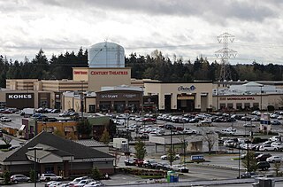
Federal Way is a city in King County, Washington, United States and part of the Seattle metropolitan area. One of the most recently incorporated cities in the county, its population was 101,030 at the 2020 census. Federal Way is the 10th most populous city in Washington and the 5th most populous in King County.

South Hill is a census-designated place (CDP) in Pierce County, Washington, immediately south of Puyallup. The population was 64,708 at time of the 2020 census, up from 52,431 in 2010. The area primarily consists of suburban housing and shopping with several retail shopping centers, residential neighborhoods, and apartment/condo complexes throughout. Because South Hill is unincorporated, its addresses are part of the Puyallup "postal city" or ZCTA.

Floyd Bennett Field is an airfield in the Marine Park neighborhood of southeast Brooklyn in New York City, along the shore of Jamaica Bay. The airport originally hosted commercial and general aviation traffic before being used as a naval air station. Floyd Bennett Field is currently part of the Gateway National Recreation Area's Jamaica Bay Unit, and is managed by the National Park Service (NPS). While no longer used as an operational commercial, military, or general aviation airfield, a section is still used as a helicopter base by the New York City Police Department (NYPD), and one runway is reserved for hobbyists flying radio-controlled aircraft.

An aerodrome or airfield is a location from which aircraft flight operations take place, regardless of whether they involve air cargo, passengers, or neither, and regardless of whether it is for public or private use. Aerodromes include small general aviation airfields, large commercial airports, and military air bases.
Dillingham Airfield is a public and military use airport located two nautical miles (4 km) west of the central business district of Mokulēʻia, in Honolulu County on the North Shore of Oʻahu in the U.S. state of Hawaii. It is operated by the Hawaii Department of Transportation under a 50-year lease from the United States Army. The airport is primarily used for gliding and sky diving operations, and also houses Civil Air Patrol (CAP) glider aircraft. Military operations consist largely of night operations for night vision device training and orientation flights for the United States Air Force Auxiliary (CAP). This airport is included in the Federal Aviation Administration (FAA) National Plan of Integrated Airport Systems for 2017–2021, in which it is categorized as a basic general aviation facility.

Crissy Field is a public recreation area on the northern shore of the San Francisco Peninsula in California, United States, located just east of the Golden Gate Bridge. It includes restored tidal marsh and beaches.

Aspen/Pitkin County Airport, also known as Sardy Field, is a county-owned public-use airport located three miles northwest of the central business district of Aspen, in Pitkin County, Colorado, United States. The airport covers an area of 573 acres (232 ha) at an elevation of 7,820 feet above mean sea level. It has one asphalt paved runway designated 15/33 which measures 8,006 by 100 feet.

Hoxton Park Airport was a general aviation aerodrome in south-western Sydney, New South Wales, Australia.

Blue Ash Airport, also known as Cincinnati–Blue Ash Airport, was a public airport located in Blue Ash, Ohio, United States and owned by the City of Cincinnati. Located 16.5 miles (26.6 km) northeast of downtown Cincinnati, it served as a general aviation reliever for the Cincinnati/Northern Kentucky International Airport.
The Fox Islands consist of the North Fox and South Fox Islands, in Lake Michigan. The uninhabited islands are approximately 17 miles (27 km) northwest of Cathead Point near the tip of the Leelanau Peninsula of Michigan and about 10 miles (16 km) southwest of Beaver Island. The two islands form part of an archipelago. South Fox Island Light was built in 1867 and operated until 1959. Both islands are part of Leelanau County, Michigan, and are administered by Leelanau Township. Several shipwrecks have occurred on the Fox Islands, or the reefs adjoining them; in 1851, the Illinois was reported as a "total wreck" on the Fox Island reef, In 1860, the bark Fontanelle ran aground at the Fox Islands, and in 1861, the schooner Nightingale. In 1873, the ships Frank Perew and Magnet encountered trouble at the Fox Islands.

Royal Air Force Chilbolton or RAF Chilbolton is a former Royal Air Force station in Hampshire, England. The airfield was located in Chilbolton approximately 4 miles (6.4 km) south-southeast of Andover.

Pagan Airstrip is a closed airfield located on Pagan Island in the United States Commonwealth of the Northern Mariana Islands, near the village of Shomu-Shon. The airport is owned by the Commonwealth Ports Authority.
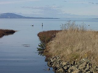
The Dotson Family Marsh, formerly Breuner Marsh, is a 238-acre regional park on San Pablo Bay in the East San Francisco Bay Area city of Richmond, California. In 2009 the East Bay Regional Parks District acquired the Breuner Marsh site, adding it to Point Pinole Regional Shoreline. A habitat restoration plan for 60 acres (24 ha) of wetlands and 90 acres (36 ha) of California coastal prairie was subsequently approved.
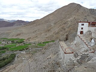
Nyoma is a principal village of southern Ladakh in India, the headquarters of an eponymous subdivision, tehsil, community development block and Indian Air Force Base in the Leh district. It is located on the bank of the Indus river after its 90-degree bend near Dungti east of Nyoma and before the valley narrows to a gorge near Mahe northwest of Nyoma. The Nyoma tehsil and subdivision cover all of southern Ladakh, including the Rupshu plains south of Nyoma, the Indus valley of Skakjung north of Nyoma, and the Hanle valley. Nyoma gompa, a Buddhist monastery, is located on the hill slope north of the village.

Harris Neck National Wildlife Refuge was established in 1962. It consists of 2,762 acres (11.18 km2) of saltwater marsh, grassland, mixed deciduous woods, and cropland located on an abandoned military airfield in McIntosh County, Georgia, north of the intersection of Route 131 and Harris Neck Airport Road, about 30 miles (48 km) southwest of Savannah, Georgia.

The Foggia Airfield Complex was a series of World War II military airfields located within a 40 km (25 mi) radius of Foggia, in the Province of Foggia, Italy. The airfields were used by the United States Army Air Forces' Fifteenth Air Force as part of the strategic bombardment campaign against Nazi Germany in 1944 and 1945, as well as the Twelfth Air Force, the British Royal Air Force and the South African Air Force during the Italian Campaign (1943–1945).

Mainz-Finthen Airfield is a recreational aerodrome in Germany, located about 3 miles (5 km) southwest of Mainz and approximately 320 miles (510 km) southwest of Berlin.
Packwood Airport is a single runway, public general aviation airport, 3 blocks west of US Highway 12 in downtown Packwood, Washington. No commercial service uses the airport, and flight operations are predominantly private, with search-and-rescue and wildfire control operations in the Gifford Pinchot National Forest and Mount Rainier National Park a significant secondary usage. It is one of two airports, including South Lewis County Airport, owned and operated by Lewis County, Washington.
Chehalis–Centralia Airport is a city-owned public use airport located in Chehalis, a city in Lewis County, Washington. The airport lies one mile (1.6 km) west of the town.
