Juropani (जुरोपानी) is a village development committee of the Jhapa district of Nepal.

Tangram is a village development committee in Baglung District in the Dhaulagiri Zone of central Nepal. At the time of the 2001 Nepal census it had a population of 3,907 and had 740 houses in the village.
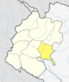
Chaukati is a village in Sindhupalchok District in the Bagmati Zone of central Nepal. At the time of the 1991 Nepal census it had a population of 2346 and had 539 houses in the village. By 2011 the population had become 2497 in 627 households.
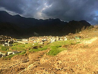
Ghumthang is a village in Sindhupalchok District in the Bagmati Zone of central Nepal. At the time of the 1991 Nepal census it had a population of 3975 and had 760 houses in the village. The rugged village hit by landslide sep 13 2020, 5 dead, 31 missing following heavy rain.
Maneshwara is a village in Sindhupalchok District in the Bagmati Zone of central Nepal. At the time of the 1991 Nepal census, it had a population of 3,065, and had 642 houses in the village. By 2011 the population had become 3,393 in 789 households.
Pagretar is a village development committee in Sindhupalchowk District in the Bagmati Zone of central Nepal. Kothe is a populated location within the committee area. In 1991, there were 633 houses, and at the time of the 2001 Nepal census Pagretar had a population of 3,352. By 2011, the population had become 2,952 in 762 households.
Pedku is a village in Sindhupalchok District in the Bagmati Zone of central Nepal. At the time of the 2013 Nepal census it had a population of 2284 and had 408 houses in the village. In 2011 the population was 1600 in 391 households.
Bageshwari is a village and Village Development Committee in Bhaktapur District in the Bagmati Zone of central Nepal. At the time of the 2011 Nepal census it had a population of 5,385 with 1,137 houses. There were 2,609 males and 2,776 females at the time of census.
Gajuri(Nepali: गजुरी ; gajuri) is a Gaupalika in Dhading District in the Bagmati Zone of central Nepal. It has a literacy rate of 64.28%. The city hosts as one of the city with highest literacy rate in the Dhading district. The local body was formed by merging three VDCs namely Gajuri, Pida, Nepal, Kiranchok.
Martadi is a town and seat of Bajura District Coordination Committee. It is also the headquarters of the Badi Malika Municipality. At the time of the 1991 Nepal census it had a population of 4,618 and had 942 houses in the town but now it has increased by growth rate of 2.62 and reached 8807.

Baganaha is a village development committee in Bardiya District in Lumbini Province of south-western Nepal. At the time of the 2011 Nepal census it had a population of 13,048 people living in 2,482 individual households. There were 6,188 males and 6,860 females at the time of census.
Baniyabhar is a village development committee in Bardiya District in Lumbini Province of south-western Nepal. At the time of the 2011 Nepal census it had a population of 17,682 people living in 3,561 individual households. There were 8,571 males and 9,111 females at the time of census.
Borlang is a village development committee in northern-central Nepal. As of the 1991 Nepal census it had a population of 4,737 and had 837 houses.
Chhoprak is a village development committee in the Gorkha District in the Gandaki Zone of northern-central Nepal. At the time of the 2011 Nepal census, it had a population of 5893 and had 1531 houses.
Chharka is a village development committee in Dolpa District in the Karnali Zone of north-western Nepal. At the time of the 1991 Nepal census it had a population of 552 persons living in 101 individual households. In the 2001 Nepal census it was found that 627 people identified as Buddhist and seven people identified as Hindu. It also stated that 544 people in 2001 were actually literate, 259 male and 285 female. there were also a total of 438 people who were non literate, 183 males and 255 females. Also according to the 2001 Nepal census there were a total of 634 people living in Chharka. Over one third of this population were in the age group of 4–19 years of age while only roughly about 9% of the population were the age of 50 or over.
Bhalam was a Village Development Committee, north of Pokhara in the Valam Municipality of Kaski District, situated in the Gandaki Zone of the Western Development Region, located in northern-central Nepal. In 2015, the VDC was amalgamated with Pokhara.
Bhakunde is a village development committee in Baglung District in the Dhawalagiri Zone of central Nepal. At the time of the 1991 Nepal census it had a population of 3,833 and had 697 houses in the village. At the time of the 2011 Nepal census it had a population of 4,952 among which 2,443 were female and 2,509 were male. There were about 831 houses in the village.
Hardauna is a village in the sub-metropolitan municipality of Maharajganj in the Kapilvastu District of the Lumbini Province. The village is in a terai region in southern Nepal. It is on the Banganga, a river which arises on the southern slopes of the Sivalik Hills and flows across the terai, reaching into Uttar Pradesh state in India.
Kopawa is a village development committee in Kapilvastu District in the Lumbini Zone of southern Nepal. At the time of the 1991 Nepal census it had a population of 7269 people living in 1142 individual households. Now from 2073 B.S. Kopawa is mixed with Banganga municipality ward no. 11.

Kumarwarti is a village development committee in Nawalparasi District in the Lumbini Zone of southern Nepal. At the time of the 1991 Nepal census it had a population of 4155 people living in 698 individual households. However data derived more recently for marriage and education details has suggested in 2001 the population had grown to over 5000.