The Delaware River and Bay Authority or DRBA is a bi-state government agency of the U.S. states of New Jersey and Delaware established by interstate compact in 1962.

The Cohansey River is a 30.6-mile-long (49.2 km) river in southern New Jersey in the United States. The river drains approximately 108 square miles (280 km2) of rural agricultural and forested lowlands on the north shore of Delaware Bay.
Raccoon Creek is a 22.6-mile-long (36.4 km) tributary of the Delaware River in southern New Jersey in the United States.
Dividing Creek is a 15.3-mile-long (24.6 km) tributary of Delaware Bay in southern New Jersey in the United States.
Oranoaken Creek is a 10.0-mile-long (16.1 km) tributary of Delaware Bay in southern New Jersey in the United States.
Stow Creek is an 18.0-mile-long (29.0 km) tributary of Delaware Bay in Salem and Cumberland counties, New Jersey in the United States.
Nantuxent Creek is a 5.5-mile-long (8.9 km) estuary of Delaware Bay in Cumberland County, New Jersey in the United States.
Oldmans Creek is a 22.1-mile-long (35.6 km) tributary of the Delaware River in southwestern New Jersey in the United States.
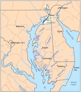
The Elk River is a tidal tributary of the Chesapeake Bay on the Eastern Shore of Maryland and on the northern edge of the Delmarva Peninsula. It is about 15 miles (24 km) long. As the most northeastern extension of the Chesapeake Bay estuary, it has served as one entrance to the Chesapeake & Delaware Canal since the 19th century. The canal and river now serve as one boundary of the Elk Neck Peninsula. The river flows through Cecil County, Maryland, with its watershed extending into New Castle County, Delaware and Chester County, Pennsylvania. Elkton, the county seat of Cecil County, is located at its head. Its total watershed area is 143 square miles (370 km2), with 21 square miles (54 km2) of open water, so its watershed is 15% open water. It is south and east of the North East River, and north of the Sassafras River.

Ridley Creek State Park is a 2,606-acre (1,055 ha) Pennsylvania state park in Edgmont, Middletown and Upper Providence Townships, Delaware County, Pennsylvania in the United States. The park, about 5 miles (8 km) north of the county seat of Media, offers many recreational activities, such as hiking, biking, fishing, and picnicking. Ridley Creek passes through the park. Highlights include a 5-mile (8 km) paved multi-use trail, a formal garden designed by the Olmsted Brothers, and Colonial Pennsylvania Plantation, which recreates daily life on a pre-Revolutionary farm. The park is adjacent to the John J. Tyler Arboretum. Ridley Creek State Park is just over 16 miles (26 km) from downtown, Philadelphia between Pennsylvania Route 352 and Pennsylvania Route 252 on Gradyville Road.

Marshallton is an unincorporated community in Mill Creek Hundred, New Castle County, Delaware, United States. The community was founded in 1836 and is named for John Marshall, mill owner.
Pennsauken Creek is a 3.8-mile-long (6.1 km) tributary of the Delaware River in Burlington and Camden counties, New Jersey in the United States.
Fort Nassau was a factorij in New Netherland between 1627–1651 located at the mouth of Big Timber Creek at its confluence with the Delaware River. It was the first known permanent European-built structure in what would become the state of New Jersey. The creek name is a derived from the Dutch language Timmer Kill as recorded by David Pietersen de Vries in his memoirs of his journey of 1630–1633. The Delaware Valley and its bay was called the "South River" ; the "North River" of the colony was the Hudson River. The factorij was established for the fur trade, mostly in beaver pelts, with the indigenous populations of Susquehannock, who spoke an Iroquoian language, and the Lenape, whose language was of the Algonquian family. They also wanted to retain a physical claim to the territory.

The Delaware National Estuarine Research Reserve consists of two unique components, one on Blackbird Creek and the other on the St. Jones River. Freshwater wetlands, ponds and forest lands dominate the Blackbird Creek component. The St. Jones component is dominated by salt marsh and open water habitats of the Delaware Bay.

Chichester is a region in Delaware County, Pennsylvania, United States, that includes the townships of Upper Chichester and Lower Chichester, and the boroughs of Marcus Hook and Trainer. Other communities included in the region are Linwood, Boothwyn, Ogden, and Twin Oaks.
Artificial Island, is an American island located along the eastern shore of the Delaware River, mostly in southwestern New Jersey with a tiny portion inside Delaware's boundaries. It is part of both Lower Alloways Creek Township, Salem County, New Jersey and New Castle County, Delaware. The island is separated from mainland New Jersey by Alloway Creek and Hope Creek. It is called "artificial" since portions of the island are composed of land reclaimed from Delaware Bay.
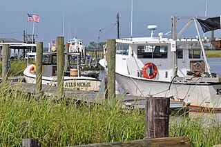
Money Island is the smallest and most remote of five rural communities that make up Downe Township in Cumberland County in the U.S. state of New Jersey. The community is located on the shore of the Delaware Bay on the southern side of Nantuxent Creek. Its location may be described as the southwest corner of New Jersey.
Red Lion Creek is a stream in the U.S. state of Delaware. It is a tributary of the Delaware River.