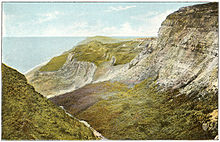
The "Back of the Wight" viewed from St Catherine's Down
Back of the Wight (also known as West Wight) is an area on the Isle of Wight in England. The area has a distinct historical and social background, and is geographically isolated by the chalk hills, immediately to the North, as well as poor public transport infrastructure. Primarily agricultural, the Back of the Wight is made up of small villages spread out along the coast, including Brighstone, Shorwell and Mottistone.
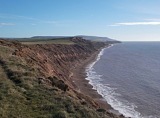
The geographical boundaries of the Back of the Wight are imprecise and vary according to interpretation, however roughly speaking it comprises all the land located South of the Downs and East of Freshwater Bay until the curve in the Downs meets the sea near St. Catherine's Point.[citation needed] The main part of the Back of the Wight[1] is formed of a large bay 18 miles long. The shore is edged by cliffs averaging around 300 feet high from Freshwater to Compton, broken at two points, Grange Chine and Brook Chine, which provide the only easy, natural access to the sea through steep gorges. Stretching out from this coast are three ledges of resistant rock, the Brook, Brighstone and Atherfield ledges, on which many ships have been wrecked over the years.
Past Compton and Brighstone, the coast is wild and there are only four access points inland, Whale, Walpen and Ladder Chine and the greatest of them all, Blackgang Chine, which was once a home of smugglers[2] and experienced a massive landslide during the early-20th century, leaving a much larger chine in its place. Blackgang Chine is home to a theme park of the same name, which was the first theme park to be constructed in the United Kingdom.
The most obvious natural features on land are the downs that enclose the area and cut it off from the rest of the island; parts of these are protected as a Site of Special Scientific Interest and large stretches owned by the National Trust. Brighstone Forest, which covers the top of Brighstone Down, is the largest on the island.
At St. Catherine's Point, the Back of the Wight ends and the Undercliff of Ventnor begins.
Geology
Like the geology of the Isle of Wight as a whole the geology of the area is varied; at Freshwater the Upper Cretaceous Chalk is exposed resulting in substantial cliffs until Compton, at this point other geological types begin to occur including clays, these formations are unique for the way the layers have been tilted exposing ancient, fossil bearing strata of the Vectis Formation overlaid with the Wessex Formation.[3] These Wealden rocks date from around 120 million years ago, thus younger than similar rocks elsewhere in the UK.
Settlements
Most of the settlements in the area are villages or hamlets that have evolved around farms or water courses. Settlement in the area has never been great and the villages are mostly old in construction.[citation needed] Many exist because of medieval churches and manors such as Mottistone Manor. The main settlements are:[4][5]
There is little evidence of the region having been settled in prehistory; apart from the Longstone[6][7] at Mottistone there are few artefacts. That there were once dinosaurs is proved by the numerous types of bones and fossils that have been excavated from the cliffs, including some species unique to the island. At the time the fossils were laid down, between 125 and 110 million years ago, the island was at a latitude similar to that of North Africa.[8] There is an abundance of fossils on the island, especially of crustaceans and nautiloids such Ammonites.
Romans
In AD 43 the Romans invaded the island, which they called Vectis. Although most of their presence was elsewhere, they did build a villa at Rock,[9]Brighstone to make use of the clean waters of the Buddle Brook. During the 4th century the Empire broke up and the coast began to suffer from raids by Germanic tribes, which repeatedly laid waste to the area.
Saxons
In Saxon times the island was colonised by Jutes until the reign of King Arwald, who died in battle when the kingdom of Wessex invaded and converted the island at sword point by killing the inhabitants and re-settling it with Saxons.[10]Saint Wilfred and the church were given large parts and converted the survivors. The island had been the last pagan part of England.[citation needed]
The Back of the Wight had a meagre and fragile economy at the time so this increased the hardships on the area by killing many of the population.[citation needed]
Middle Ages
During medieval times the people of the Back of the Wight were very poor, particularly compared to the new prosperity of towns such as Yarmouth, Newtown and Brading. The people lived a harsh existence exposed to the elements and pirates. They scraped a livelihood from fishing, farming and salvage. Shipwrecks were a great help to these people and some say that the emphasis was on cargo not people. There has never been any proof of islanders wrecking, but given how harsh their lives were it would not be surprising. In 1313, in a famous case the St Mary of Bayonne, from Gascony, ran ashore at Chale Bay. The lord of Chale raised some men and demanded the 53 barrels of wine the ship was carrying. When King Edward II found out, he summoned them to Southampton and had them fined. The wine was destined for a monastery and the church cried sacrilege. As a result of this incident, the first lighthouse on Wight was built at Chale, the St Catherine's Oratory,[11] where the lord's family paid for a light and prayers for his soul. This is the oldest medieval lighthouse in England.[12] Its ruins are now known as the Pepperpot, and a half-built later lighthouse nearby is known as the Salt Shaker. From this period onwards the area lived in fear of French invasions.
18th century and beyond
In the 18th century there were a succession of stormy winters that increased the number of wrecks on the Back's coast. Salvage and theft were combined with thriving local smuggling. Many buildings in the area are formed of parts of these ships. The Coastguard were established on the island at this time. They were hated because they fought the smuggling trade, although they were hardly saints; there is an interesting local tale about the commander of the Yarmouth station who "couldn't hear" the sounds of a raging gun battle going on at Alum Bay between smugglers and Coastguard. In 1859 the first lifeboats were put in place at Brighstone and Brook; they took part in many famous rescues and are commemorated in Brighstone Museum, which has many artefacts of the era.
When in 1892 the SSEider,[13] a German liner, went aground on the Atherfield Ledge, it took "virtually the whole of the sparse human population of the 'Back of the Wight' to get them to sea".[14]
Mottistone Manor and Garden, Isle of Wight
Also in the late 19th century, the area first became popular to visit and some noted figures established homes here, like Mottistone Manor for the noted architects, the Seelys.[15]
On 18 December 2014, A Boeing 767 carrying United Airlines Flight UA28 suffered an engine failure while travelling towards Los Angeles from London Heathrow Airport, and entered a holding pattern over the Back of the Wight for several hours while it dumped fuel, eventually returning to Heathrow some hours later.[citation needed]
Noted shipwrecks
The Back of the Wight has very little in the way of suitable shelter for sailing vessels and prevailing SW storm winds often forced ships onto the coast. The three ledges of rock that extend underwater at Atherfield, Brighstone and Brooke can cause unpredictable water conditions. As a result of the high volume of shipwrecks that occurred RNLI lifeboat stations were established, one at each of these locations. Several local books include detailed accounts of the lifeboat and coastguard rescues of the sailors of the many ships that have been wrecked on the area's dangerous coast. Some of the more high-profile vessels include:
The area is still poorly connected, particularly as erosion threatens the A3055 Military Road[16] ("Millie" to locals), which runs along the coast connecting them. Compton bay and beach are popular with surfers due to waves that come across the Atlantic. Recent cuts have made the bus service more infrequent.
Economy
The economy of the area is largely agricultural and rural with farming using most of the land area. Despite the long coastline, there is little or no local fishing. Tourism provides a significant part of local income and many sites in the area are popular.
Agriculture is still the dominant economic activity of the land. Many residents of the area have Newport as their centre of commerce and culture, using the road over the down to reach it.[17]
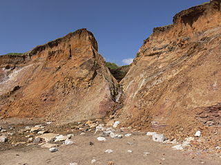
A chine is a steep-sided coastal gorge where a river flows to the sea through, typically, soft eroding cliffs of sandstone or clays. The word is still in use in central Southern England—notably in East Devon, Dorset, Hampshire and the Isle of Wight—to describe such topographical features. The term 'bunny' is sometimes used to describe a chine in Hampshire. The term chine is also used in some Vancouver suburbs in Canada to describe similar features.
Blackgang Chine is the oldest amusement park in the United Kingdom, having opened in 1843. Named after a now-destroyed chine in the soft Cretaceous cliffs, it is about 6 miles from Ventnor at the southern tip of the Isle of Wight just below St Catherine's Down. Blackgang Chine are owned by the Dabell family. Blackgang Chine is home to many lands of imagination, including Pirate Cove, Restricted Area 5, Fairy Land and Village, and Cowboy Town. Owing to the unstable land on which the park is situated, landslides occur frequently, meaning that attractions have been moved further inland to safer ground on several occasions.
Brook is a village and former civil parish, now in the parish of Brighstone, on the Isle of Wight, England. In 1931 the parish had a population of 156. On 1 April 1933 the parish was abolished and merged with Brighstone.
Shorwell is a village and civil parish on the Isle of Wight, United Kingdom. It is 4+1⁄2 miles (7.2 km) from Newport in the southwest of the island. Shorwell was one of Queen Victoria's favourite places to visit on the Isle of Wight.
Chale is a village and civil parish on the Isle of Wight of England, in the United Kingdom. It is located three kilometres from Niton in the south of the Island in the area known as the Back of the Wight. The village of Chale lies at the foot of St. Catherine's Down.
Foreland or Forelands, and the adjacent Foreland Fields, is the easternmost point of the Isle of Wight, part of the village of Bembridge. It is located about 6.5 miles due south of the city of Portsmouth on the British mainland, separated by the eastern reaches of the Solent. It is characterised by a pub called the Crab and Lobster Inn and various beach huts plus a beach cafe and a coast guard lookout. In the sea are the reefs of Bembridge Ledge which is rich in edible crabs, lobsters and spider crabs and shoals of mackerel. In the Crab & Lobster Inn are photographs of the many shipwrecks, which included the submarine HMS Alliance, now a museum ship at Gosport and the First World War troopship the S.S. Mehndi carrying troops from South Africa, with great loss of life.
Atherfield is a rural location in the south west of the Isle of Wight, UK. It includes the small settlements of Atherfield Green and Little Atherfield, as well as several farms, and is set in largely open farmland. To the south west it is bounded by the cliffs of Chale Bay and Brighstone Bay, which are divided by Atherfield Point. The south-eastern part of Brighstone Bay is also sometimes known as Atherfield Bay, and was the site of a former holiday camp, now demolished.
Brighstone is a village and civil parish on the Isle of Wight, 6 miles southwest of Newport on the B3399 road. Brighstone was previously known as "Brixton". The name derives from the Saxon name "Ecgbert's Tun".
Blackgang is a village on the south-western coast of the Isle of Wight, England. It is best known as the location of the Blackgang Chine amusement park which sits to the south of St Catherine's Down.
Whale Chine is a geological feature near Chale on the south-west coast of the Isle of Wight, England. One of a number of such chines on the island created by stream erosion of soft Cretaceous rocks, it is a narrow and steep coastal ravine dropping 140 feet through Lower Greensand rocks from clifftop farmland to Chale Bay.
Grange Chine and Marsh Chine form a geological feature on the south west coast of the Isle of Wight, England. They lie to the south of the village of Brighstone.
Shepherd's Chine is a geological feature on the south west coast of the Isle of Wight, England. It lies to the west of the village of Little Atherfield.
Chale Bay is a bay on the south-west coast of the Isle of Wight, England. It lies to the west of the village of Chale from which it takes its name. It faces south-west towards the English Channel, its shoreline is 3+1⁄4 miles (5.2 km) in length and is gently curving. It stretches from Artherfield Point in the north-west to Rocken End in the south-east.
Freshwater Redoubt, also known as Fort Redoubt, is an old Palmerston fort built in Freshwater Bay on the western end of the Isle of Wight. Construction work for the fort began in 1855 and was completed in 1856. It was finally sold in 1928 and has now been converted into a private residence.
Brighstone Bay is a bay on the south west coast of the Isle of Wight, England. It lies to the south and west of the village of Brighstone from which it takes its name. It faces south west towards the English Channel, its shoreline is 7 km in length and is gently curving. It stretches from Sudmoor Point in the north west to Artherfield Point in the south east.
Atherfield Ledge is a rocky outcrop extending from the coast of the Back of the Wight, Isle of Wight. This is a famous shipwreck location. Along with Brook Ledge and Brighstone Ledge it is one of the area's main shipping hazards.
Brighstone Grange Lifeboat Station was located at Grange Chine, near the village of Brighstone, formerly Brixton, on the south west coast of the Isle of Wight.
Brook Lifeboat Station was located at Brook Chine, near the village of Brook, on the south west coast of the Isle of Wight.
Atherfield Lifeboat Station was located at Atherfield Point, near the village of Atherfield, on the south west coast of the Isle of Wight.
This page is based on this Wikipedia article Text is available under the CC BY-SA 4.0 license; additional terms may apply. Images, videos and audio are available under their respective licenses.