Related Research Articles
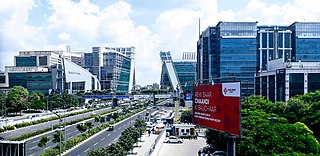
Haryana is an Indian state located in the northern part of the country. It was carved out of the former state of East Punjab on 1 November 1966 on a linguistic basis. It is ranked 21st in terms of area, with less than 1.4% of India's land area. The state capital is Chandigarh, which it shares with the neighboring state of Punjab, and the most populous city is Faridabad, which is a part of the National Capital Region. The city of Gurgaon is among India's largest financial and technology hubs. Haryana has 6 administrative divisions, 22 districts, 72 sub-divisions, 93 revenue tehsils, 50 sub-tehsils, 140 community development blocks, 154 cities and towns, 7,356 villages, and 6,222 villages panchayats.

Bhiwani district is one of the 22 districts of the northern Indian state of Haryana. Created on 22 December 1972, the district was the largest district of the state by area, before the creation of Charkhi Dadri as a separate district, as it occupied an area of 4,778 square kilometres (1,845 sq mi) and administered 442 villages with a population of 1,634,445. Sirsa is now the largest district of the state.

Mahendragarh district is one of the 22 districts of Haryana state in northern India. The district occupies an area of 1,899 km² and has a population of 922,088 (2021census). District have 3 Sub-divisions : Narnaul, Mahendragarh and Kanina
Faridabad district is one of the 22 districts of the Indian state of Haryana with Faridabad city being the district headquarters. The Delhi-Mathura-Agra National Highway 44 passes through the centre of the district, which occupies an area of 741 square kilometres (286 sq mi) and as of the 2011 census of India had a population of 1,809,733. Haryana government has created a new Faridabad division which would cover the districts – Faridabad, Nuh and Palwal.

Kaithal district is one of the 22 districts of Haryana, a state in northern India. Kaithal town is the district headquarters. The district occupies an area of 2317 km2. It has a population of 1,074,304. It is part of Karnal division. Kaithal was notified as district by Haryana Govt. on 16 October 1989 and carved out of Kurukshetra and Jind districts, comprising Guhla and Kaithal sub-divisions of Kurukshetra district, Kalayat sub-tahsil and 6 villages of Jind district.

Yamunanagar district is one of the 22 districts of the Indian state of Haryana. The district came into existence on 1 November 1989 and occupies an area of 1,756 square kilometres (678 sq mi). Yamunanagar town is the district headquarters.

Sonipat is a city & administrative headquarter in Sonipat district of Haryana state of India. It comes under the National Capital Region and is around 44 kilometres (27 mi) from New Delhi. It is also around 214 km southwest of Chandigarh, the state capital. The Yamuna River runs along the eastern boundary.
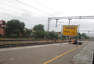
Palwal is a city and a municipal council. It is the headquarters of Palwal district, the 21st district of Haryana state in northern India. It is a centre of the cotton trade in the area. It is also a part of National Capital Region.

Hodal is a town and a municipal council in Palwal district in the Haryana state of India. It is located at 27°53′39″N77°22′09″E and has an average elevation of 190 meters.

Nuh district is one of the 22 districts in the Indian state of Haryana. There are four sub-divisions in this district: Nuh, Ferozepur Jhirka, Punahana, and Taoru. It has an area of 1,860 square kilometres (720 sq mi) and had a population of 1.09 million in 2011. It is bounded by Gurugram District to the north, Palwal District of Haryana to the east and Alwar District of Rajasthan to the south and west. Its boundaries also touch Bharatpur District of Rajasthan and Mathura District of Uttar Pradesh near Bichhor Village and Nai Village of Punhana Tehsil. It is predominantly populated by farmers of Meo ethnicity.
Jewar is a town and a nagar panchayat in Gautam Buddha Nagar District in the Indian state of Uttar Pradesh.

Kalsia was a princely state in Punjab, British India, one of the former Cis-Sutlej states. It was founded by Raja Gurbaksh Singh Sandhu in 1760. After India's independence, it was included in PEPSU and later in the Indian East Punjab after the States Reorganisation Act, 1956. The area of Kalsia is now located in the modern day Indian states of Punjab and Haryana. In 1940 the population of Kalsia was 67,393. Kalsia was ruled by Jat Sikhs.

Palwal district was created on 15 August 2008. It is the 21st district of Haryana state in northern India. Palwal City is the headquarters of the district. It is part of the Braj region.
Bahal is a small town in the Loharu tehsil in the Bhiwani district of the Indian state of Haryana. Situated near the town of Rajgarh on the Haryana-Rajasthan border, it lies 54 kilometres (34 mi) south west of the district capital Bhiwani and 160 kilometres (99 mi) south west of the National capital Delhi. And Rajiv Gandhi Stadium is on it.
Kushak is also called Bainsla village and the largest village in the Palwal district of the Haryana state in India. As of the 2011 census, the village had a population of 5487 people. Kushak village sits on the bank of the Yamuna river about 40 miles south-east of the Indian capital New Delhi. It is the largest village of the Bainslat tribe.
Gurgaon Assembly constituency is one of the 90 constituencies in the Haryana Legislative Assembly of Haryana a north state of India. Gurgaon is also part of Gurgaon Lok Sabha constituency.

Tigaon Assembly constituency is a Haryana Legislative Assembly constituency in Faridabad Haryana.
Banchari is a village in the mandal of Hodal, Palwal district, Haryana state, India.

Faridabad Division is one of the six divisions of Haryana state of India. It comprises the districts of Faridabad, Palwal and Nuh. It was announced in January 2017 and approved by the Haryana cabinet on 2 February 2017.
References
- ↑ "Badoli". 2011 Census of India . Government of India. Archived from the original on 21 September 2017. Retrieved 21 September 2017.
- ↑ Neela Mukherjee; Meera Jayaswal (2006). Chained by food: marginalized voices from peri-urban India. Concept Publishing Company. p. 120. ISBN 8180692388.
28°04′48″N77°26′06″E / 28.080°N 77.435°E
| | This Haryana location article is a stub. You can help Wikipedia by expanding it. |