
The Indus is a transboundary river of Asia and a trans-Himalayan river of South and Central Asia. The 3,180 km (1,980 mi) river rises in mountain springs northeast of Mount Kailash in Western Tibet, flows northwest through the disputed region of Kashmir, bends sharply to the left after the Nanga Parbat massif, and flows south-by-southwest through Pakistan, before emptying into the Arabian Sea near the port city of Karachi.
Topi is a town in the eastern part of the Swabi District of Khyber Pakhtunkhwa province of Pakistan. The administrative division of Topi unfolds into two Union councils: Topi East and Topi West. Notably, the Tarbela Dam, largest earth-filled dam in the world, is located only 9 kilometres (5.6 mi) east of Topi.

Nowshera is the capital city of Nowshera District in the Khyber Pakhtunkhwa province of Pakistan. It is the 78th largest city in Pakistan and ninth largest city in the province of Khyber Pakhtunkhwa.

Gomal Zam Dam is a multi-purpose gravity dam in South Waziristan Tribal District of Khyber Pakhtunkhwa, Pakistan. The dam impounds the Gomal River, a tributary of the Indus River, at Khjori Kach, where the Gomal River passes through a narrow ravine. The purpose of the dam is irrigation, flood control, and hydroelectric power generation. Construction of the dam began in August 2001 and was completed in April 2011. The powerhouse was completed in March 2013 and electricity production started in August 2013. The dam was officially inaugurated on 12 September 2013 by Minister for Water and Power Khawaja Muhammad Asif, along with US Ambassador Richard G. Olson and Khyber Pakhtunkhwa Governor Shaukatullah Khan.

Ladakh is an administrative territory of India that has been under its control since 1947. The geographical region of Ladakh union territory is the highest altitude plateau region in India, incorporating parts of the Himalayan and Karakoram mountain ranges and the upper Indus River and valley.

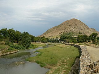
Hund, known in antiquity as Udabhandapura, is a small village in Swabi district, situated on the right bank of the Indus River in the Khyber Pakhtunkhwa province of Pakistan. It is about 15 km upstream of Attock Fort and is located 80 km to the east of Peshawar.
Lāhor (لاهور), also known as Little Lahore, previously known as Salatura (سلاطوره), is a town within the Swabi District of Khyber Pakhtunkhwa, Pakistan. The town serves as the headquarters of the Lahor Tehsil and is administratively subdivided into two union councils. The town is a settlement of 35,000 people and is located at 34°02′54″N72°21′56″E with an altitude of 308 metres and lies west of Swabi and on the northern bank of the Indus River. In the vicinity of Lahor are Panjpir, Hund and Zaida three other cities of the ancient world.
Panjpir is a town and Union council of Swabi District in the Khyber Pakhtunkhwa province of Pakistan that is surrounded by Shahmansoor, Kaddi, Thand Kohi, Bam Khel, Darra and Ismailabad.Panj peer means five Sufi Sanits. District Swabi has 4 Tehsils i.e. Swabi Tehsil, Lahor, Topi Tehsil and Razar. Each Tehsil comprises certain numbers of union councils. There are 56 union councils in district Swabi.
Beka is a town and Union Council of Swabi District in the Khyber Pakhtunkhwa of Pakistan. It is part of Lahor Tehsil.
Jehangira is a town in the Khyber-Pakhtunkhwa province of Pakistan.
Zarobai Munara, commonly known as Zarobi, is a historical village and Union Council of Swabi District in the Khyber Pakhtunkhwa province of Pakistan. It is located at 34°2′0N 72°34′0E with an altitude of 321 metres.
Kaddi(کڈی) is a village in the Swabi District of Khyber-Pakhtunkhwa. The inhabitants belong to Aba Khel subtribe of Mandanr Yusufzai Pakhtuns who occupy Swabi and Mardan districts of Khyber-Pakhtunkhwa. The major khel living in Kaddi include Balar Khel, Taju Khel, Zakarya Khel, Khan Khel and Panj Pao.

Thandkoi is a historic village of Swabi District of Khyber Pakhtunkhwa Province of Pakistan. The population is about 30,000. Thandkoi is situated on the main Jehangira-Topi road. A small village Dodher is located on its south, to the north of Thandkoi is Bamkhel, east Marghuz and to the west is Kaddi and Zaida.
Buddha Nullah or Buddha Nala is a seasonal water stream, which runs through the Malwa region of Punjab, India, and after passing through highly populated Ludhiana district, Punjab, India, it drains into Sutlej River, a tributary of the Indus River. Today, it has also become a major source of pollution in the region as well the main Sutlej river, as it gets polluted after entering the highly populated and industrialized Ludhiana city, turning it into an open drain. Also, since large area in south-western Punjab solely depend on the canal water for irrigation, and water from Buddha Nullah enters various canals after Harike waterworks near Firozpur, thus affecting far-reaching areas such as Malout, Zira, upper Lambi, while the areas being fed by Sirhind feeder, are the most-affected by its pollution.

Demchok , previously called New Demchok, and called Parigas by the Chinese, is a village and military encampment in the Indian-administered Demchok sector, that is disputed between India and China. It is administered as part of the Nyoma tehsil in the Leh district of Ladakh by India, and claimed by China as part of the Tibet Autonomous Region.

Hund Museum is an archaeology museum located in Hund, near the bank of the Indus River north of Attock, Swabi district, Khyber Pakhtunkhwa, Pakistan. It is frequented by thousands of visitors annually.
The Charding Nullah, traditionally known as the Lhari stream and called Demchok River by China, is a small river that originates near the Charding La pass that is also on the border between the two countries and flows northeast to join the Indus River near a peak called "Demchok Karpo" or "Lhari Karpo". There are villages on both sides of the mouth of the river called by the same name "Demchok", which is presumed to have been a single village originally, and has gotten split into two due to geopolitcal reasons. The river serves as the de facto border between China and India in the southern part of the Demchok sector.
The Demchok sector is a disputed area named after the villages of Demchok in Ladakh and Demchok in Tibet, situated near the confluence of the Charding Nullah and Indus River. It is a part of the greater Sino-Indian border dispute between China and India. Both China and India claim the disputed region, with a Line of Actual Control between the two nations situated along the Charding Nullah.


