Related Research Articles

Also see Ratannagar, Churu

Sathamba is a town located in Aravali district of the Indian state of Gujarat and the seat of a former petty princely state. It has a population of approximately 15,000. It was ruled by Kshatriya Baria Kolis having Thakor title.
Bhadresar or Bhadreshwar is a village in Mundra Taluka, Kutch district of Gujarat, India. It is about 27 km from Taluka headquarters Mundra and barely a kilometer away from the seashore.
Bhuvad or Bhuwad is a village in Anjar Taluka of Kutch district of Gujarat, India.

All Saints' Church is in Queens Road, Hertford, Hertfordshire, England. It is an active Anglican parish church in the deanery of Hertford and Ware, the archdeaconry of Hertford, and the diocese of St Albans. It is the civic church of the town and of the county. The church is recorded in the National Heritage List for England as a designated Grade II* listed building. It is the largest church in Hertfordshire, other than St Albans Cathedral, and can seat up to 1,000 people.
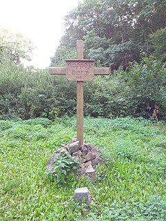
The Kappelberg, at 358 metres, is the highest hill in Rhenish Hesse in central Germany. It lies in the forest of Vorholz between Bechenheim, Orbis and Oberwiesen near the border with the Palatinate.

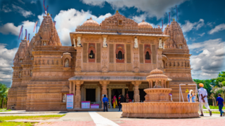
Bhadreshwar Jain Temple, also known as Vasai Jain Temple, is a historical importance located in Bhadreshwar village of Mundra Taluka, Kutch, Gujarat, India.
Chitrod is a village near Rapar of Kutch district of Gujarat, India.
Gedi is a village near Rapar of Kutch district of Gujarat, India.

Gundiyali is a village near Mandvi of Kutch district of Gujarat, India.
Katariya is a village in Bhachau Taluka of Kutch district of Gujarat, India. The villages is now divided into two parts; Juna (old) and Nava (new) Katariya.
Rav is a village of three hamlets; Rav Moti, Rav Nani and Temple; in an open plain, located nineteen miles from Chobari, in Rapar Taluka of Kutch district of Gujarat, India.
Sikra is a village in Bhachau Taluka of Kutch district of Gujarat, India.
Talvana or Tanvana is a village in Mandvi Taluka of Kutch district of Gujarat, India.
Vira is a village in Anjar Taluka in Kutch district of Gujarat, India. Nearby temple of Jogninar is place of religious significance.
Patgadh or Vagham Chavdagadh was a historical town and capital of western Kutch during rule of Chawda dynasty. The ruins of the town is located in Lakhpat Taluka in Kutch district of Gujarat, India. The village is on the west bank of Little Rann of Kutch.
Antaliya is a village in Amreli district in the Indian state of Gujarat.
Bagasara-Ghed, also known as Bagasara (Sil), is a village in Mangarol Taluka of Junagadh district, Gujarat, India. Bagasra-Ghed lies thirty-four miles to the south-west of Junagadh.
Bherai is a village in Rajula Taluka of Amreli district, Gujarat, India.
Chogath (Thapnath) is a village in Umrala Taluka of Bhavnagar district, Gujarat, India. It is a former princely state.
References
- ↑ Gazetteer of the Bombay Presidency: Cutch, Palanpur, and Mahi Kantha (Public Domain Text). Printed at the Government Central Press. 1880. p. 213.

Coordinates: 22°58′54″N69°47′19″E / 22.98167°N 69.78861°E
| This article about a location in Kutch district, Gujarat, India is a stub. You can help Wikipedia by expanding it. |