Bahundangi, the name is believed to be founded by a Brahmin woman who was a very kind hearted and selfless. She spent all her life towards helping people and since she was Brahmin and every single person was very happy with her; they soon decided to pronounce the area as, “Bahundangi”. It is also believed that, she died of high fever at an age about 57 and was buried near the river in Bahundangi and today it is also known as, “Bahunijhoda” which also means the River of Brahmin.
Economy
The majority of population fall under middle class categories. People are mostly self-sustained by growing their own crops. There are weekly markets held such that people can trade their products.People are also engaged in government public services work as well as a majority of population has gone to foreign lands in search of jobs. There is also a youth trend of joining the Indian and British Army. The majority of the people are farmers, mostly cultivating rice, tea, Areca nuts, ginger, mushroom, etc. In the past, there used to be only one market, also called Bahundangi Bazar, held on Thursday of every week. The local vendors as well as those from India used to come to sell their products, especially, clothes, groceries and basic materials. At Present days, there are a lot of such markets held on different days in different places within Bahundangi. It has helped the people to avail themselves of all the basic needs without having need to go far. This market trend has been followed by the native of Bahundangi for more than 100 years. Because of its open border, people also have free access to India where they go for trading goods, shopping and health treatment. The adjoining Indian markets are Naxalbari and Silguri.
The total population is 22897 according to 2001 census and the major ethnicity living here are Brahmins, Cheetri, Newar, Magar, Marwari, Rai, Limbu, etc.
Transportation
Transportation is an important means for Trading goods. Since, Bahundangi lies at the border of India, people mostly uses Trucks, Tractors to trade their goods to India and vice versa. There are several Buses that directly runs from Bahundangi to Kathmandu, the capital city of Nepal on a daily basis. Also, several Buses and Cabs are available that runs from Bahundagi and connects to major cities like, Kakarvitta, Birtamode, Biratnagar, Dharan etc.
Climate
Bahundangi which lies at the bank of Mechi River and near Illam District has a Moderate Climate. The average Temperature in summer is recorded as 33°C and 6°C in Winter Season.[2]
Sports
Bahundangi Jaycess had organized an invitational football tournament on 30 August 2012 (14 Bhadra 2069) in Bahundangi. The participating teams were Munal Club (Host Team) Birtamod Youth Club, APF Jhapa, Morang XI, Sunsari XI, UKFC Darjeeling and SAI Academy Siliguri.[3][importance?]
Recently, Bahundangi Youth Club has organized "Late Fanda Singh Pandey Memorial Knockout Football Tournament" in the memory of Fanda Singh Pandey, the founding chairperson of Bahundangi Youth Club from 17th to 24th of Jestha 2075. The participating teams were Bahundangi Youth Club (Host Team), Sanischare Youth Club, New Star Youth Club, Munal Club, Birtamode United, APF Padajungi, Kakarvitta Football Training Centre & Damak Fc. president: Bikram Thapa, secretary general: Nikesh Dahal
From very early times, Bahundangi is most rewarded VDC for sports among VDC's in Jhapa
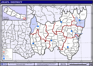
Jhapa District is a district of Koshi Province in eastern Nepal named after a Rajbanshi Surjapuri language word "Jhapa", meaning "to cover" (verb). The 2021 Nepal Census, puts the total population of the district at 994,090. The total area of the district is 1,606 square kilometres.
Birgunj is a metropolitan city in Parsa District in Madhes Pradesh in southern Nepal. It lies 135 km (84 mi) south of the capital Kathmandu, attached in the north to Raxaul on the border of the Indian state of Bihar. As an entry point to Nepal from Patna, Birganj is known as the "Gateway of Nepal". It is also called the "Commercial Capital of Nepal". The town has significant economic importance for Nepal as most of the trade with India is via Birganj and the Indian town of Raxaul. The Tribhuvan Highway links Birgunj to Nepal's capital, Kathmandu.
Butwal, officially Butwal Sub-Metropolitan City ,previously known as Khasyauli, is a sub-metropolitan city and economic hub in Lumbini Province in West Nepal. Butwal has a city population of 195,054 as per the 2021 AD Nepal census.
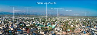
Damak is one of the oldest municipalities in Jhapa District of Koshi Province in eastern Nepal. It is situated between the Ratuwa River in the east and the Maawa River in the west. It has Sivalik Hills in its north and ends with the intersection of Ratuwa River and Maawa River in the south. Mahendra Highway, the longest highway of Nepal, bisects the municipality .It is the largest city in Jhapa District with a population of 107,410 in 2021.
Mechinagar is a municipality in Jhapa District, Koshi Province, Nepal and is the main entry point from India on Nepal's eastern border. Nepal's customs office is in Kakarvitta, a section of the municipality. The city lies 475 km southeast of the capital Kathmandu and 115 km east of Biratnagar, the capital of Province No. 1.
Juropani (जुरोपानी) is a village development committee of the Jhapa district of Nepal.
Birtamod is a municipality in Jhapa District of Nepal. It is the commercial, educational and transport hub of Jhapa District. Sarnamati Bazar, Dhulabari Bazar, Dhaijan Bazar, Charali Bazar, Shivasatakshi Bazar, Kamatoli Bazar, Chakchaki Bazar and Surunga Bazar are some of the nearest local towns/settlements connected to Birtamod. It is one of the fastest growing cities in Nepal and one of the largest cities of Jhapa.
Budhabare, more specifically Hadiya Budhabare, is a village and former Village Development Committee that is now part of Buddhashanti Rural Municipality in Jhapa district of Province No. 1 in south-eastern Nepal. The latest official data, 2011 Nepal Census, puts the total population of the VDC at 22,936. Owing to this average population size, the VDC has been divided into nine wards.
Bhadrapur, or Chandragadhi, is a town and municipality in Jhapa District in the Koshi Pradesh of southeastern Nepal. It lies on the banks of the Mechi River and shares borders with Bihar on the south and West Bengal on the north. There is a border crossing with a customs office for goods. Galgalia village in Kishanganj district borders Bhadrapur.
Dhulabari is a town in Jhapa District in the Province No. 1 of south-eastern Nepal. It is part of Mechinagar Municipality.
Haldibari is a village development committee (VDC) in Jhapa District in the Province No. 1 of southeastern Nepal. Haldibari, from Haldi, means besar/turmeric. At the time of the 1991 Nepal census it had a population of 6,407 people living in 1,167 individual households.
Khudunabari is a village development committee in Jhapa District in the Province No. 1 of south-eastern Nepal. At the time of the 1991 Nepal census, it had a population of 10,674 people living in 1867 individual households. It is connected via Sanischare Road to Mahendra Highway. Its neighbouring VDC s are Arjundhara, Lakshmipur and Shantipur of Illam District. It area comprises both plain and hilly. It has a moderate climate.
Surunga is a trade center of Jhapa District. It is located in Kankai Municipality in Jhapa District in the Koshi Province of south-eastern Nepal. At the time of the 1991 Nepal census it had a population of 16,747 people living in 2996 individual households. Surunga is one of the rapidly developing towns of Jhapa district. It is situated on the bank of the Kankai River.
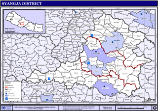
Pindikhola was a village development committee in Syangja District in the Gandaki Zone of central Nepal. At the time of the 2011 Nepal census it had a population of 4,956 people living in 1,119 individual households.
Rajgadh is one of the villages in the southern part of the Jhapa district in Nepal. Its elevation range is 80–120 m above sea level. Some of its land area is covered with dense forest, known as the Charkose Jhadi. Its neighbouring VDCs are Chakchaki, Goldhhap, Sharanamati, Jalthal and Gherabari. It also borders India.
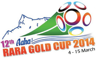
The 2014 Aaha! Rara Gold Cup is the 12th edition of the Aaha Gold Cup held in Pokhara and organised by Sahara Club. 12 teams participated in the tournament. The defending champions Three Star Club have chosen not to compete. All matches were held at the Pokhara Rangasala. Due to a sponsorship deal with Him-Shree Foods, the tournament is officially known as the 12thAaha! Rara Gold Cup 2014. Which is named after its flagship product, "RARA" instant noodles.
The 2015 Nepal National League also known as the RedBull National League for sponsorship reasons was the 2nd edition of Nepal National League. The winners Three Star Club received 1 Crore or 10 million rupees.
Birat Gold Cup is an annual football tournament held in Biratnagar, the second largest metropolitan city of Nepal. It has been held at the Sahid Rangsala stadium since 2012. The event witnesses participation from several national and international teams, and is among the most prestigious football tournaments of the nation.
The 2015 Budha Subba Gold Cup was the 17th edition of the Budha Subba Gold Cup held in Dharan and sponsored by Red Bull. Seven teams from Nepal and one from India participated in the tournament. All matches were held at the ANFA Technical Center Dharan. A lot of changes were made regarding the format of the tournament, the tournament took place in February as opposed to April, when it previously took place. Also, the prize money for the winning team was increased to make the tournament more attractive. Belgharia Sporting Club from Calcutta, India, who won this tournament in 1999, was also meant to join the tournament but was replaced by another Indian Team, Sikkim Sunalchu FC.
The India–Nepal border is an open international boundary running between the republics of India and Nepal. The 1,751 km (1,088.02 mi) long border includes the Himalayan territories as well as Indo-Gangetic Plain of the subcontinent. The current border was delimited after the Sugauli treaty of 1816 between Nepal and the British Raj. Following Indian independence, the prevailing border was recognised as the international border between the Kingdom of Nepal and the Dominion of India.
This page is based on this Wikipedia article Text is available under the CC BY-SA 4.0 license; additional terms may apply. Images, videos and audio are available under their respective licenses.