
Jhapa District is a district of Koshi Province in eastern Nepal named after a Rajbanshi Surjapuri language word "Jhapa", meaning "to cover" (verb). The 2021 Nepal Census, puts the total population of the district at 994,090. The total area of the district is 1,606 square kilometres.

Birtamod is a municipality in Jhapa District of Nepal. It is the commercial, educational and transport hub of Jhapa District. Sarnamati Bazar, Dhulabari Bazar, Dhaijan Bazar, Charali Bazar, Shivasatakshi Bazar, Kamatoli Bazar, Chakchaki Bazar and Surunga Bazar are some of the nearest local towns/settlements connected to Birtamod. It is one of the fastest growing cities in Nepal and one of the largest cities of Jhapa.
Myanglung is a municipality and the district headquarters of Terhathum District of Koshi Province in eastern Nepal. The "myang" means cat and "lung" means stone in Limbu language.The story is that the cat (myang) in ancient time, pawed the stone (lung) in anger. The municipality is situated at an elevation of about 1500 metres above sea level. Myanglung was converted into a municipality from a village development committee on 18 May 2014, merging the existing village development committees of Myanglung, Piple, Jirikhimti, Ambung, Sabla and Tamphula. According to the census of 2011 the total population of Myanglung is 19,659 including five VDCs.
Chandika is a business center in Sanphebagar Municipality in Achham District in the Seti Zone of western Nepal. It was annexed to form the new municipality since 18 May 2014. At the time of the 1991 Nepal census, the village had a population of 2129 living in 446 houses. At the time of the 2001 Nepal census, the population was 2383, of which 45% was literate.

Arjundhara is the name of a temple that is situated in south-eastern part of Nepal. It is situated in Jhapa district, Province No. 1 in Nepal. It is 45 minutes on flight from Kathmandu to Bhadrapur and 30 minutes car ride from Bhadrapur to Arjundhara. It is 6 km north from the business centre Birtamode, Previously it used to be in Arjundhara VDC ward no. 04. and now it lies in Arjundhara Municipality. As Nepal is recently divided into provinces this place lies in the Province no.01.
Charpane (चारपाने) is a business center in Birtamod Municipality in Jhapa District in the Province No. 1 of south-eastern Nepal. At the time of the 1991 Nepal census it had a population of 7766 people living in 1472 individual households. Ramchowk is a Chautari popular for local meeting and discussion platform for the people living in this area. There is a small jungle of SAAL from which the jungle is given a name of SAALGHARI. There is a local public school named Mohanmaya School. Bal Kalyan Boarding School is besides of Charpane Chowk(चारपाने चोक).
Ghailadubba is a small town and ancient market place in Kankai Municipality near the Biring river in Jhapa District in the Province No. 1 of south-eastern Nepal. At the time of the 1991 Nepal census it had a population of 11,185.

Surunga is a trade center of Jhapa District. It is located in Kankai Municipality in Jhapa District in the Koshi Province of south-eastern Nepal. At the time of the 1991 Nepal census it had a population of 16,747 people living in 2996 individual households. Surunga is one of the rapidly developing towns of Jhapa district. It is situated on the bank of the Kankai River.

Phidim Municipality is the headquarters of Panchthar District in the Koshi Province of eastern Nepal. Its old name is Pheden, which in Limbu langauage means land on top of hills. Phidim was the capital of Panthar Thum of Limbuwan and was upgraded from a village to a municipality when a development committee merged with other VDCs - including Phidim Chokmagu and Siwa villages - on May 18, 2014. It offers a route for trekkers and locals to and from the Taplejung district bordering the Tibetan Autonomous Region of China. It is also a commercial hub for the rural surroundings.

Belbari, officially known as Belbari municipality, is one of the major suburb of Morang district, Koshi Province. It lies in the eastern Terai region of Nepal. Previously a Village Development Committee (VDC), it was upgraded to the municipality status in 2014. In order to meet the requirements to become a municipality, Belbari VDC merged Kaseni VDC with itself, making it larger in total area. Moreover, in 2017 AD VDC like Dangihat and Bahuni merged with it to become present Belbari Municipality. Now it have 11 wards offices. It had a population of 81,771 people living in 18,945 households making it the third most populous city in Morang district.
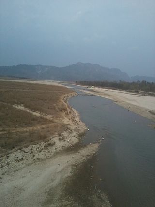
The Kankai River is a trans-boundary river flowing through the hills of Ilam and the plains of the Jhapa District in Nepal. It begins at the confluence of the Mai Khola and Deb Mai Khola rivers.

Dhimal is a Sino-Tibetan language of Nepal spoken by about 20,000 people, mainly in the Terai of Koshi Province. There is an eastern and western dialect, which are separated by the Kankai River. Most people transcribe Dhimal into Devanagari and there are standard conventions for extra phonological distinctions.
Shivasatakshi is a municipality in the southeastern part of Jhapa District in the Koshi Province of eastern Nepal. The new municipality was formed by merging four existing VDCs—Shivaganj, Satasidham, Dharampur, and Panchgachhi—on 2 Dec 2014. The office of the municipality is that of the former Satasidham village development committee (VDC).

Kotihom Dham is a religious site in Eastern Development Region, Nepal. It is located in the Kankai Municipality of Jhapa District. Other names it famously goes by are Kankai Mai and Kankai Dham.

The Jamunkhadi Simsar or Jamunkhadi Wetlands is a wetlands conservation project in the Kankai municipality of Jhapa District, in eastern Nepal.

Shree Harikul Model Higher Secondary School also called Shree Harikul in short is a privately owned secondary school in Kankai Municipality, Surunga, Jhapa District, Nepal, established in 1995. It is one of the oldest schools in the locality which has been running through the private sector and in English medium.

Arjundhara is a municipality in Jhapa District of Province No. 1 in Eastern Nepal. It was formed in 2014 by merging the former village development committees Arjundhara, Shanischare, and Khudunabari. It was named Shani-Arjun initially but was changed to Arjundhara again in January 2017. It is named after a holy place situated here, Arjundhara Temple. At the time of the 2011 Nepal census it had a population of 60,205 people living in 13,623 individual households.

A municipality in Nepal is an administrative division in the Provinces of Nepal. The urban population of Nepal refers to the inhabitants residing in the designated municipal area. Population size has been taken as the principal criteria in the declaration of urban areas in Nepal since 1961. Municipalities can therefore also include rural areas. It functions as a sub-unit of a district. Nepal currently has 293 municipalities, which given the 2011 population estimate of 16,656,057.

Jhapa 2 is one of five parliamentary constituencies of Jhapa District in Nepal. This constituency came into existence on the Constituency Delimitation Commission (CDC) report submitted on 31 August 2017.

Jhapa 4 is one of five parliamentary constituencies of Jhapa District in Nepal. This constituency came into existence on the Constituency Delimitation Commission (CDC) report submitted on 31 August 2017.


