Jamunkhadi Simsar

Last updated
Jamunkhadi Simsar
Jamun khadi simsar.JPG
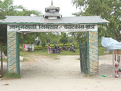
Gate to wetlands area
Nepal adm location map.svg
Red pog.svg
Jamunkhadi Simsar
Jamunkhadi in map of Nepal
Coordinates: 26°31′N87°28′E / 26.52°N 87.47°E / 26.52; 87.47 Coordinates: 26°31′N87°28′E / 26.52°N 87.47°E / 26.52; 87.47
countryFlag of Nepal.svg    Nepal
zone Mechi zone
District Jhapa District

The Jamunkhadi Simsar or Jamunkhadi Wetlands is a wetlands conservation project in the Kankai municipality of Jhapa District, in eastern Nepal.

Kankai Municipality Place in Mechi Zone, Nepal

Kankai Municipality is a municipality in Jhapa District of eastern Nepal.

Jhapa District District in Kirat, Nepal

Jhapa is one of 14 districts of Kirat of eastern Nepal. The latest official data, the 2011 Nepal Census, puts the total population of the district at 812,650.

Nepal country in South Asia

Nepal, officially the Federal Democratic Republic of Nepal, is a landlocked country in South Asia. It is located mainly in the Himalayas but also includes parts of the Indo-Gangetic Plain. With an estimated population of 26.4 million, it is 48th largest country by population and 93rd largest country by area. It borders China in the north and India in the south, east, and west while Bangladesh is located within only 27 km (17 mi) of its southeastern tip and Bhutan is separated from it by the Indian state of Sikkim. Nepal has a diverse geography, including fertile plains, subalpine forested hills, and eight of the world's ten tallest mountains, including Mount Everest, the highest point on Earth. Kathmandu is the nation's capital and largest city. Nepal is a multiethnic nation with Nepali as the official language.

Contents

It was created to be developed as a tourist destination in Wards 2 and 5 of Surunga VDC (which are now the Dandagau area of Kankai), within the community forest. It lies about a kilometer away from the East-West Highway and occupies an area of about 10 hectares of the 25-hectare community forest. [1] Originally, it included two ponds named after the rivers Ganga (Ganges) and Jamuna, but due to lack of protection, Ganga no longer exists and currently only Jamuna remains.

Surunga Town in Mechi Zone, Nepal

Surunga is a trade center of Jhapa District. It is located in Kankai Municipality in Jhapa District in the Mechi Zone of south-eastern Nepal. At the time of the 1991 Nepal census it had a population of 16,747 people living in 2996 individual households. Surunga is one of the rapidly developing towns of Jhapa district. It is situated on the bank of the Kankai River.

Mahendra Highway road in Nepal

Mahendra Highway, also called East-West Highway runs across the Terai geographical region of Nepal, from Mechinagar in the east to Bhim Datta in the west, cutting across the entire width of the country. It is the longest highway in Nepal and was constructed by CPWD/PWD Nepali and Indian engineers.

Ganges river in Bangladesh and India with major tributeries from Nepal

The Ganges, or Ganga, is a trans-boundary river of the Indian subcontinent which flows through the nations of India and Bangladesh. The 2,525 km (1,569 mi) river rises in the western Himalayas in the Indian state of Uttarakhand, and flows south and east through the Gangetic Plain of North India. After entering West Bengal, it divides into two rivers: the Hooghly and the Padma River. The Hooghly, or Adi Ganga, flows through several districts of West Bengal and into the Bay of Bengal near Sagar Island. The other, the Padma, also flows into and through Bangladesh, and joins the Meghna river which ultimately empties into the Bay of Bengal.

Jamuna pond is a tourist attraction. [2] [3] There is boating and fishing on the pond. Wild animals such as the python, bear, sambar, and porcupine are protected in this area.

<i>Python</i> (genus) genus of reptiles

Python is a genus of constricting snakes in the Pythonidae family native to the tropics and subtropics of the Eastern Hemisphere. Currently, 10 python species are recognized.

Bear Family of mammals

Bears are carnivoran mammals of the family Ursidae. They are classified as caniforms, or doglike carnivorans. Although only eight species of bears are extant, they are widespread, appearing in a wide variety of habitats throughout the Northern Hemisphere and partially in the Southern Hemisphere. Bears are found on the continents of North America, South America, Europe, and Asia. Common characteristics of modern bears include large bodies with stocky legs, long snouts, small rounded ears, shaggy hair, plantigrade paws with five nonretractile claws, and short tails.

Sambar deer species of mammal

The sambar is a large deer native to the Indian subcontinent, southern China, and Southeast Asia that is listed as Vulnerable on the IUCN Red List since 2008. Populations have declined substantially due to severe hunting, insurgency, and industrial exploitation of habitat.

Tourism

Image of jamun pokhari simsar.JPG

Related Research Articles

A Ramsar site is a wetland site designated to be of international importance under the Ramsar Convention.

Caroni Swamp The second largest mangrove wetland in Trinidad and Tobago

The Caroni Swamp is the second largest mangrove wetland in Trinidad and Tobago. It is located on the west coast of Trinidad, south of Port of Spain and northwest of Chaguanas, where the Caroni River meets the Gulf of Paria.

Wetlands International is a global organisation that works to sustain and restore wetlands and their resources for people and biodiversity. It is an independent, not-for-profit, global organisation, supported by government and NGO membership from around the world.

Riverland Region in South Australia

The Riverland is a region of South Australia. It covers an area of 9,386 square kilometres (3,624 sq mi) along the Murray River from where it flows into South Australia from New South Wales and Victoria downstream to Blanchetown. The major town centres are Renmark, Berri, Loxton, Waikerie, Barmera and Monash, along with many minor townships; the population is approximately 35,000 people.

Matthews Beach, Seattle Neighborhood in Seattle

Matthews Beach is a neighborhood in Seattle, Washington; it and Meadowbrook are the southern neighborhoods of the annexed township of Lake City (1954). Matthews Beach lies about 2 miles (3 km) northeast of the University of Washington, about 8 miles (13 km) northeast of Downtown.

Lough Oughter

Lough Oughter is a lake, or complex of lakes, in County Cavan covering more than 8,900 hectares. The complex of lakes lies on the River Erne, and forms the southern part of the Lough Erne complex. The lakes are bounded roughly by Belturbet in the north, Cavan town to the east, Crossdoney to the south and Killeshandra to the west.

Polar Bear Pass

Polar Bear Pass is a 262,400 hectare wetland and mountain pass on Bathurst Island within the Qikiqtaaluk Region, Nunavut, Canada. The pass is on federal Crown land.

Tourism in Belize

Tourism in Belize has grown considerably recently, and it is now the second largest industry in the nation. Belizean Prime Minister Dean Barrow has stated his intention to use tourism to combat poverty throughout the country. The growth in tourism has positively affected the agricultural, commercial, and finance industries, as well as the construction industry. The results for Belize's tourism-driven economy have been significant, with the nation welcoming almost one million tourists in a calendar year for the first time in its history in 2012.

Myanglung Municipality in Province No. 1, Nepal

Myanglung is a municipality and the district headquarters of Terhathum District of Province No. 1 in eastern Nepal. The municipality is situated at an elevation of about 1500 metres above sea level. Myanglung was converted into a municipality from a village development committee on 18 May 2014, merging the existing village development committees of Myanglung, Piple, Jirikhimti, Ambung, Sabla and Tamphula. According to the census of 2011 the total population of Myanglung is 19,659 including five VDCs.

Piccaninnie Ponds Conservation Park Protected area near Mount Gambier in South Australia

Piccaninnie Ponds Conservation Park, formerly the Piccaninnie Ponds National Park, is a protected area of 862 hectares located in southeastern South Australia near Mount Gambier.

Pond A relatively small body of standing water

A pond is an area filled with water, either natural or artificial, that is usually smaller than a lake. It may arise naturally in floodplains as part of a river system, or be a somewhat isolated depression. It may contain shallow water with marsh and aquatic plants and animals.

Black Pond Wildlife Management Area

Black Pond Wildlife Management Area is a 526-acre (213 ha) New York State Wildlife Management Area (WMA) that lies on the eastern shore of Lake Ontario, and at the northern limit of an unusual region of sandy barrier beaches and lagoons. Much of the barrier beach in Black Pond WMA has forested sand dunes that are about 60 feet (18 m) high; these are the highest sand dunes in the northeast United States excepting Cape Cod. Immediately north of the WMA is the 360-acre (150 ha) El Dorado Beach Preserve, which is a bird refuge owned by The Nature Conservancy. North of the outlet from Black Pond to Lake Ontario, the shoreline is a weathered, flat bedrock shelf that is "calcareous" instead of sandy.

Sandy Pond Beach Unique Area

Sandy Pond Beach Unique Area is a 76-acre (31 ha) New York State conservation area located within the eastern Lake Ontario dunes. It lies at the north end of a spit of land dividing North Sandy Pond from Lake Ontario, and is about two miles (3.2 km) north of the developed portion of Sandy Island Beach State Park. There is no road access to the area, which can be most easily reached by boat. For this reason, local residents have long referred to the beach as "Boaters' Beach". It has been managed as part of Sandy Island Beach State Park since 2011.

Coxs Creek, a watercourse of the Cooks River catchment, is located in the Inner West of Sydney, in New South Wales, Australia.

Kankai River river in India

The Kankai River (Nepali: कन्काई नदी, is a trans-boundary river flowing through Ilam and Jhapa in north to south direction of Nepal. Holy river of millions of Hindu Devotees living throughout Nepal. Passes through the hills of Ilam and plains of Jhapa District. Kotihom river Bank is the centre for Death rituals of millions of Hindus living in Jhapa and Ilam. Kankai Irrigation Project launched by Nepal government irrigates the southern Jhapa like Shivganj, Pachgachi, Mahavara etc. Kanki Mai or Mai khola has the several points of tourism like Domukha, Dhanuskoti, Chuli, Chepti and Maipokhari. The river overfloods during the monsoon and has possibility to overflow through the thousands of hector of fertile plains of Jhapa. It is really beautiful to view the local fisherman fishing in the river and the children taking bath in heat of sun. Kotihom Surunga Municipality holds annual Mai Mela Fair where Millions of people from Jhapa, Morang, Ilam and various parts of India come to enjoy and perform the religious activity on the Day of Magh 1st. Kankai Aryaghat for death rituals in Kotihom bank of the river built recently by the public investment is used for death rituals each day by the people.

Alto Loa National Reserve

Alto Loa National Reserve is a Protected Area located in the province of El Loa, Antofagasta region, Chile. Announced in 2002 and created in 2005, it is Chile's largest natural reserve.

Salburua protected area

Salburua is a wetland habitat on the eastern outskirts of the city of Vitoria-Gasteiz in the Basque Country in Spain. The area, which is part of the city green belt, contains lakes, meadows and oak groves. It was drained in the 19th century to transform the area into farmland. Restoration work started in 1994 and has reversed this situation and now Salburua is a Ramsar Wetland of International Importance. The Salburua marshes are considered to be "the Basque country's most valuable area of wetland", according to a Fedenatur report for the European Commission in 2004.

Attenborough Nature Reserve nature reserve in the United Kingdom

Attenborough Nature Reserve is a nature reserve at Attenborough, Nottinghamshire, England, located 7 Kilometres south west of Nottingham city centre. It is managed by Nottinghamshire Wildlife Trust in partnership with the site's owners, Cemex, supported by Broxtowe Borough Council. At its centre is a building called Attenborough Nature Centre, comprising visitor services and educational facilities.

Sawbridgeworth Marsh Essex Wildlife Trust Nature reserve

Sawbridgeworth Marsh is a 6.3 hectare biological Site of Special Scientific Interest (SSSI) near Sawbridgeworth in Hertfordshire, apart from a small area in the north which is in Essex. It is managed by the Essex Wildlife Trust. The planning authorities are East Hertfordshire District Council and Uttlesford District Council.

References

  1. Tourism Office Kakarvitta. "जामुनखाडी सिमसार क्षेत्र". Tourism Office Kakarvitta. Tourism Office Kakarvitta. Retrieved 27 January 2016.
  2. "Jamunkadhi Simsar region". Birattourism.org.np. Archived from the original on 2015-01-02. Retrieved 2016-01-09.
  3. [[[:ne:जामुनखाडी सिमसारक्षेत्र|जामुनखाडी सिमसारक्षेत्र]] "जामुनखाडी सिमसारक्षेत्र - विकिपीडिया"] Check |url= value (help). Ne.wikipedia.org (in Nepali). Retrieved 2016-01-09.