Surunga

Last updated
Surunga
सुरुंगा
Kanakai
Nepal adm location map.svg
Red pog.svg
Surunga
Location in Nepal
Coordinates: 26°40′N87°54′E / 26.66°N 87.90°E / 26.66; 87.90
Country Nepal
Province Koshi province
District Jhapa District
Population
 (1991)
  Total16,747
Time zone UTC+5:45 (Nepal Time)
Area code 23
Surunga Bazaar, Jhapa, Nepal. Surunga bazaar.JPG
Surunga Bazaar, Jhapa, Nepal.
Surunga Bazaar on weekly Saturday haat in Jhapa, Nepal. Surunga haat1.JPG
Surunga Bazaar on weekly Saturday haat in Jhapa, Nepal.
Surunga Bazaar on weekly Saturday haat in Jhapa, Nepal. Surunga haat2.JPG
Surunga Bazaar on weekly Saturday haat in Jhapa, Nepal.
Street shops at Surunga Bazaar on weekly Saturday haat. Surunga haat3.JPG
Street shops at Surunga Bazaar on weekly Saturday haat.
Utensils shops at Surunga Bazaar on weekly Saturday haat. Surunga haat4.JPG
Utensils shops at Surunga Bazaar on weekly Saturday haat.
Utensils shops at Surunga Bazaar on weekly Saturday haat. Surunga haat5.JPG
Utensils shops at Surunga Bazaar on weekly Saturday haat.
Street shops at Surunga Bazaar on weekly Saturday haat. Surunga haat6.JPG
Street shops at Surunga Bazaar on weekly Saturday haat.
People in Street shops at Surunga Bazaar on weekly Saturday haat. Surunga haat7.JPG
People in Street shops at Surunga Bazaar on weekly Saturday haat.

Surunga is a trade center of Jhapa District. It is located in Kankai Municipality in Jhapa District in the Koshi Province of south-eastern Nepal. At the time of the 1991 Nepal census it had a population of 16,747 people living in 2996 individual households. Surunga is one of the rapidly developing towns of Jhapa district. It is situated on the bank of the Kankai River (also known as Kankai Mai by the locals).

Contents

Geography

It is bordered by Ilam district on the north mostly while it also shares a border with Khudnabari VDC, Kankai river flows to its west (on the western bank of which lie Shivasatakshi), to the east lies Ghailadubba and Arjundhara VDCs and at the south it is surrounded by Sharnamati and Dangibari VDCs. Being one of the few villages in Jhapa through which East-west Highway runs also makes the village one of the most important towns in the region. It has significant religious importance due to its being on the bank of Kankai river where the famous Koti Hom Religious Area is situated.

Surunga was named after its historical meaning: Surung (Tunnel). It is believed that five brothers from Hindu mythology mahabharat along with their mother kunti escaped from the palace and finally reached Surunga underground.

Population

Estimated population in 2001 census was around 17,000 but currently this could be around 35,000 with a large influx of people from different villages of Eastern hills and various parts of India. Ethnicities in Surunga are Bhramin, Chhetri, Satar, Kami, Damai, Newar, Bhujel, Tamang, Agrawal, Rajbanshi, Dhimal, Sarki, Magar, Rai and Limbu among others. Out of all the ethnicities, Satar and Rajbanshi are underprivileged in Surunga.[ citation needed ]

Education

In Surunga is located the government-run Kankai Madhyamik Vidyalaya, which caters for around 3,000 students every year not only from Surunga but also from surrounded villages. The boarding schools are Shree Pashupati English Secondary School, Shree Harikul Model Higher Secondary School, Paragon Academy Secondary School, Champa Flowers Academy, Jhapa Marigold English School, Mai valley English School, Dibya Ratna English Secondary School, Shree Banubajha English school (Surunga 7), Janaki primary school (Surunga 8), Devkota Education Foundation and Hamro Pathashala.

There are other primary boarding schools in Surunga. For higher education, Kankai Multiple Campus is running courses for certificate, bachelors and masters levels. Shree Harikul Model Higher Secondary School also runs higher secondary education also known as 10+2.

Kankai Higher Secondary School is the pioneer school in Surunga. It also runs classes in symbolic language up to grade 10 for hearing-impaired students.

Economy

Surunga's main economy rests on agriculture. However, now remittance, local businesses and tourism also contribute significant amount to the economy of Surunga village. In recent times, real estate business is also a vital means of economic activities. The cost of land is increasing each day making about 10 million for one Katha in main points of Surunga. It contains a group of A-graded banks certified by Nepal Rastra Bank (NRB) which includes NRB, Agricultural Development Bank (ADBL), BiratLaxmi Development Bank, Excel Development Bank, Sunrise Bank, NMC Jhapa, Prithivi Saving and Credit Society. Simultaneously a group of 'saving and credit' companies are also working. Leading among them is Bhagwati Saving and Credit Pvt Limited which has more than 400 share members.

Koti Hom (a hom ritual in Hindu religion) was conducted by late yogi Naraharinath, a Hindu yogi and philosopher, in 1985. Now Koti Hom is going to be developed as a tourist place. Movie filming and photography can be done there paying a little charge in KotiHom Dharmik Sthal Bikash Samiti (a committee which manages the Koti Hom area). A place for trekking freaks called jhandi dada (झन्दी डाँडा) is located in the border of Surunga which is shared with Illam.

No bandas

Surunga is one of the best place for business opportunities because of its anti-strike stance. It is one of the most important educational and business centers in the region. No political parties, ethnic groups or professional organization has been able to shut down Surunga bazaar over the last few years. Defying all manner of bandas, Surunga has earned a reputation as the country's only anti-banda town. The locals say Surunga bazaar has not been closed down even for a single day in the last six years. According to District Traffic Police Office Jhapa, the district has seen shutdowns for 31 days in the last two years. But, no banda has had any impact in Surunga. In the past, the locals of Surunga have even chased away political party cadres trying to shut down the bazaar by force. Due to this reason trade is easy in Surunga.

Religious and touristic sites

Surunga is famous for Kotihome religious site that lies on the westernmost point of the VDC. Every year hundreds of thousands of devotees flock to this area to worship. The most remarkable occasion is Makar Sankranti when Maghe Mela is organized which is attended by thousands of people from as far as Biratnagar, Dharan, Itahari, Ilam, Kakarvitta and Indian states of West Bengal (mostly Darjeeling and Jalpaiguri), southern Bhutan and Assam.[ citation needed ]

Domukha is a tourist destination in the eastern part of Nepal. Kankai river flows through the Chure range of hills, comes and reaches the plains of Terai region. Because of the Domukha Dam that was constructed to build Kankai Nahar (channel), there's a huge reservoir of water which is serene and clear most of the year. Many youngsters visit this place for picnic, field visit, excursions and simply to cool off from the scorching heat. Domukha is also a connecting point to Surunga for people living in high hills and southern Ilam. According to mythology, around this area used to be the palace of Kirant King in the history.

These days another religious place has become visited, Dhanushkoti Dham, which is supposed to be place of "Arjun's meditation in The Mahabharat". Its growing to be one of the most important religious sites and picnic place nowadays. A more fascinating fact about it is that this lies just the opposite bank of Damukha.

Kankai Bridge: The bridge over the Kankai river is one of the long concrete bridge in the country and measures 703 meters. The longest barrage/dam is on Koshi River and the longest bailey bridge is on Mahakali River connecting rest of Nepal to the 2 Nepali villages beyond Mahakali called Chandani and Dodhara villages.

Jamunkadhi Simsar, where many animals like deer, pythons, bears, sambar deer and porcupine are protected, is also located in this VDC.

A park named Happy Land has been established recently and is gaining popularity among the local tourists. The park is located on the bank of Sankha Khola, approximately 1 km north from the town.

Health services

Surunga has a government-run primary health care center that is staffed by a medical doctor, health assistant, AHW, nurses and other helpers. The PHC also has vaccination center for snake bite which is a highly prevalent condition in the region especially from the Cobra and Krait. Besides, there are a lot of pharmacy stores like Sitaula Pharmacy, Pradhan Medical, Asmita Medical etc. that mostly sell medicines to the people and also provide consultation related to medical conditions with the help of medical doctors who rotate on hourly basis. Recently, Marigold Hospital and Sidhakali Hospital have been set up to cater to the growing health needs of the people. However, there is no medical institution in Surunga that can provide inpatient services to the people. When they have major health problems, the citizens of Surunga have to either go to Damak, a bigger city in western Jhapa that has AMDA clinic or to Dharan BPKIHS where the largest medical institution of Eastern Nepal is situated. Some of the people also travel as far as Siliguri, second largest city in West Bengal state of India for better treatment. People also travel to Kathmandu for treatment.

Drinking water: Surunga has drinking water supply that is collected from underground water and treated before distributed to the taps in every house. This was constructed by the initiative of local people and support from the district development committee. The drinking water project covers most parts of the VDC. It is also ranked one of the best drinking water service in the Eastern Region of Nepal. Prior to this, people used to drink tube well water which wasn't treated before drinking and contained a lot harmful minerals for health including arsenic that is linked with cancers and other skin conditions. [1]

Media

To promote local culture, Surunga has an FM radio station named Radio Sandesh - 103.9 MHz, which is run by a public library (Kankai pustakalaya) and is also registered as a Community radio.

Organizations

Amongst many: Surunga Cooperate Youth Club, Sahkarya Sarthi Samuha, Surunga Jaycees, Sahakarya girls group, Sahakarya child Group, Youth Forum Surunga, Gayan Joti Yuwa club and Bal Club.

Related Research Articles

<span class="mw-page-title-main">Jhapa District</span> A district in eastern Nepal

Jhapa District is a district of Koshi Province in eastern Nepal named after a Rajbanshi Surjapuri language word "Jhapa", meaning "to cover" (verb). The 2021 Nepal Census, puts the total population of the district at 994,090. The total area of the district is 1,606 square kilometres.
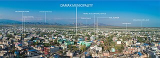
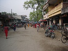
<span class="mw-page-title-main">Damak Municipality</span> Municipality in Nepal

Damak, a city in eastern Nepal, is one of the oldest municipalities in Jhapa District in Koshi Province in eastern Nepal. It is situated between the Ratuwa River in the east and the Maawa River in the west. It has Sivalik Hills in its north and ends with the intersection of Ratuwa River and Maawa River in the south. Mahendra Highway, the longest highway of Nepal, bisects the municipality. It is the largest city in Jhapa District with a population of 107,410 in 2021.

Juropani (जुरोपानी) is a village development committee of the Jhapa district of Nepal.

<span class="mw-page-title-main">Birtamod Municipality</span> Municipality of Jhapa district, Nepal

Birtamod is a municipality in Jhapa District of Nepal. It is the commercial, educational and transport hub of Jhapa District. Sarnamati Bazar, Dhulabari Bazar, Dhaijan Bazar, Charali Bazar, Shivasatakshi Bazar, Kamatoli Bazar, Chakchaki Bazar and Surunga Bazar are some of the nearest local towns/settlements connected to Birtamod. It is one of the fastest growing cities in Nepal and one of the largest cities of Jhapa.

<span class="mw-page-title-main">Budhabare, Jhapa</span> Village of Buddhashanti Rural Municipality in Province No. 1, Nepal

Budhabare, more specifically Hadiya Budhabare, is a village and former Village Development Committee that is now part of Buddhashanti Rural Municipality in Jhapa district of Province No. 1 in south-eastern Nepal. The latest official data, 2011 Nepal Census, puts the total population of the VDC at 22,936. Owing to this average population size, the VDC has been divided into nine wards.

Ekatappa is a town and Village Development Committee in Ilam District in the Province No. 1 of eastern Nepal. At the time of the 1991 Nepal census it had a population of 4,320 persons living in 784 individual households.

Sulubung is a Village Development Committee in Ilam District in the Province No. 1 of eastern Nepal. At the time of the 1991 Nepal census it had a population of 3,470. Maipokhari, one of the major tourist and religious place of Nepal lies here. A company named Hesty Kiwi Private Limited has been established in this region which had helped to popularize this village with the plantation of kiwifruit. It is about 15 km from Ilam Bazaar. It is a hilly area having cold climate and mainly tea production is the income of most of the people here.

Hariwan Municipality is one of the new municipalities declared by the Government of Nepal on May 18, 2014. It is located in Sarlahi District Janakpur zone, Nepal. It is formed by the joining of four contemporary Village development committees (VDCs) namely Atrouli, Sasapur, Ghurkauli and Harion VDCs covering an area of 88.1 km2. It has been divided into 11 wards with an administration center in Harion Bazar. According to Nepal Population Census 2011, the municipality has a total population of 42,783.

<span class="mw-page-title-main">Bhadrapur Municipality</span> Town in Jhapa District, Nepal

Bhadrapur is a town and municipality in Jhapa District in the Koshi Pradesh of southeastern Nepal. It lies on the banks of the Mechi River, and shares borders with Bihar state, India on the south and West Bengal state on the north. There is a border crossing with a customs office for goods. Galgalia village in Kishanganj district borders with Bhadrapur

Dangibari is a village development committee in Jhapa District in the Province No. 1 of south-eastern Nepal. At the time of the 1991 Nepal census it had a population of 7472.

<span class="mw-page-title-main">Kawasoti</span> Kawasoti municipality in Gandaki Province, Nepal

Kawasoti (Nepali: कावासोती) is a municipality in Nawalpur District, Gandaki Province, Nepal. It is 31 km (19 mi) west of Bharatpur and 85 km (53 mi) east of Butwal, approximately on the middle of Mahendra Highway. The Naryani River flows south of it, and the Mahabharat Range is north of it.

<span class="mw-page-title-main">Kankai River</span> River in Nepal

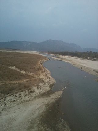
The Kankai River is a trans-boundary river flowing through the hills of Ilam and the plains of the Jhapa District in Nepal. It begins at the confluence of the Mai Khola and Deb Mai Khola rivers.

Rajgadh is one of the villages in the southern part of the Jhapa district in Nepal. Its elevation range is 80–120 m above sea level. Some of its land area is covered with dense forest, known as the Charkose Jhadi. Its neighbouring VDCs are Chakchaki, Goldhhap, Sharanamati, Jalthal and Gherabari. It also borders India.

Baniyatol is a village in Kohabara VDC, Jhapa District in the Mechi Zone of south-eastern Nepal. It is one of the most developed village in Kohabara VDC. As estimated in 2011, it had a population of approx. 100 people living in their own house.

Shivasatakshi is a municipality in the southeastern part of Jhapa District in the Koshi Province of eastern Nepal. The new municipality was formed by merging four existing VDCs—Shivaganj, Satasidham, Dharampur, and Panchgachhi—on 2 Dec 2014. The office of the municipality is that of the former Satasidham village development committee (VDC).

<span class="mw-page-title-main">Jamunkhadi Simsar</span> Tourist attractions in Mechi zone, Nepal

The Jamunkhadi Simsar or Jamunkhadi Wetlands is a wetlands conservation project in the Kankai municipality of Jhapa District, in eastern Nepal.

<span class="mw-page-title-main">Shree Harikul Model Higher Secondary School</span> Private school in Surunga, Nepal

Shree Harikul Model Higher Secondary School also called Shree Harikul in short is a privately owned secondary school in Kankai Municipality, Surunga, Jhapa District, Nepal, established in 1995. It is one of the oldest schools in the locality which has been running through the private sector and in English medium.

<span class="mw-page-title-main">Koshi Province</span> Province of Nepal

Koshi Province is the autonomous easternmost province adopted on 20 September 2015 by Constitution of Nepal. The province is rich in natural resources, tourist attractions, recreational activities, and natural beauty. The province covers an area of 25,905 km2 (10,002 sq mi), about 17.5% of the country's total area. With the industrial city of Biratnagar as its capital, the province includes major eastern towns of Birtamod, Sundar Haraincha, Damak, Dharan, Itahari, Triyuga Municipality and Mechinagar, and the Mount Everest, Kangchenjunga and Ama Dablam. Koshi River, the largest river of the nation, forms the province's western boundary. Under the First-past-the-post voting system issued by the Constituency Delimitation Commission, Nepal, the province hosts 28 parliamentary seats and 56 provincial assembly seats.

<span class="mw-page-title-main">Dakneshwori Municipality</span> Municipality in Eastern Development Region, Nepal

Dakneshwori Municipality is located in Saptari District in Madhesh Province of Nepal. It was formed in 2016 occupying current 10 sections (wards) merging previous Kabilasha, Hariraha, Tarhi, Bhuthi, Pato, Aurahi, Brahampur, Gamahariya Parwaha, Patthargada and Banaula VDCs. It occupies an area of 69.11 km2 with a total population of 44,782. Dakneshwori Municipality is named after the famous temple Dakneshwori Bhagwati located at ward no. 5, Pato.

The Mai Khola is a river in eastern Nepal, the headwater of the Kankai River. Its water is used for irrigation and also powers several hydroelectric plants.

References

  1. "Nepal Census 2001". Nepal's Village Development Committees. Digital Himalaya . Retrieved 24 November 2008.