
Tihar is a five-day spiritual and cultural Hindu festival of lights celebrated by Nepalese as well as by the Indian Gorkhas inhabiting Sikkim state and Territories. Tihar is analogous to the Indian festival of Diwali, the festival of lights, but both are different Festival.
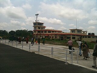
Bhadrapur Airport, also known as Chandragadhi Airport, is a domestic airport located in Bhadrapur, primarily serving Jhapa and Ilam districts in Koshi Province, Nepal. The Civil Aviation Authority of Nepal considers it an important hub for passengers entering Nepal from the north eastern states of India, and the passengers from Bhutan and Bangladesh.

Mechinagar is a municipality in Jhapa District, Koshi Province, Nepal and is the main entry point from India on Nepal's eastern border. Nepal's customs office is in Kakarvitta, a section of the municipality. The city lies 475 km southeast of the capital Kathmandu and 115 km east of Biratnagar, the capital of Province No. 1.

Birtamod is a municipality in Jhapa District of Nepal. It is the commercial, educational and transport hub of Jhapa District. Sarnamati Bazar, Dhulabari Bazar, Dhaijan Bazar, Charali Bazar, Shivasatakshi Bazar, Kamatoli Bazar, Chakchaki Bazar and Surunga Bazar are some of the nearest local towns/settlements connected to Birtamod. It is one of the fastest growing cities in Nepal and one of the largest cities of Jhapa.
Tokha Chandeshwari is a village and former Village Development Committee that is now part of Tokha Municipality in Kathmandu District in Province No. 3 of central Nepal. At the time of the 2011 Nepal census it had a population of 3,961. Tokha Chandeshwari now is part of Tokha municipality.
Bhalam was a Village Development Committee, north of Pokhara in the Valam Municipality of Kaski District, situated in the Gandaki Zone of the Western Development Region, located in northern-central Nepal. In 2015, the VDC was amalgamated with Pokhara. Bhalam is located around 950 m above sea level, 5 km from the city of Pokhara.

Arjundhara is the name of a temple that is situated in south-eastern part of Nepal. It is situated in Jhapa district, Province No. 1 in Nepal. It is 45 minutes on flight from Kathmandu to Bhadrapur and 30 minutes car ride from Bhadrapur to Arjundhara. It is 6 km north from the business centre Birtamode, Previously it used to be in Arjundhara VDC ward no. 04. and now it lies in Arjundhara Municipality. As Nepal is recently divided into provinces this place lies in the Province no.01.

Bahundangi was a village development committee in Jhapa District in the Province No. 1 of South-Eastern Nepal. From 2017, this VDC is officially merged by Government with Mechinagar Municipality

Bhadrapur, or Chandragadhi, is a town and municipality in Jhapa District in the Koshi Pradesh of southeastern Nepal. It lies on the banks of the Mechi River and shares borders with Bihar on the south and West Bengal on the north. There is a border crossing with a customs office for goods. Galgalia village in Kishanganj district borders Bhadrapur.
Dhulabari is a town in Jhapa District in the Province No. 1 of south-eastern Nepal. It is part of Mechinagar Municipality.
Haldibari is a village development committee (VDC) in Jhapa District in the Province No. 1 of southeastern Nepal. Haldibari, from Haldi, means besar/turmeric. At the time of the 1991 Nepal census it had a population of 6,407 people living in 1,167 individual households.

Surunga is a trade center of Jhapa District. It is located in Kankai Municipality in Jhapa District in the Koshi Province of south-eastern Nepal. At the time of the 1991 Nepal census it had a population of 16,747 people living in 2996 individual households. Surunga is one of the rapidly developing towns of Jhapa district. It is situated on the bank of the Kankai River.
Rajghat is a small village in the Urlabari Municipality, comprising two wards; 8 and 9 in the Morang District in the Koshi Zone of south-eastern Nepal. It is located in North-East part of Morang and 1.5 kilometers south of the East West national highway of Nepal. Durgapuri Bazar is the local town of Rajghat. This place is one of the major habitat of indigenous Dhimal, Santhal,and Mushahar communities.
Goldhap refugee camp is a small refugee camp in Nepal populated by just over 4,600 Bhutanese refugees as of 2011. Because of its dwindling population, the UNHCR merged Goldhap into the nearby Beldangi refugee camps. The camp is located near the settlement of Goldhap, along the Thulo Bato Road, directly abutting the Charali Jungle in Jhapa.
Gaindakot is a municipality in Nawalpur District in the Gandaki Zone of southern Nepal. It became a municipality in May 2014 by merging the existing Mukundapur, Amarapuri, and Gaindakot VDCs. It was again expanded by merging Ratanpur VDC. It is situated on the shore of Narayani River in the lap of Maula Kalika temple. So this place has a great possibility of tourism development. At the time of the 2011 Nepal census, it had a population of 58,841 and 13,623 individual households according to 2011 Nepal census.
Buddhabhumi is a Municipality in Kapilvastu District in the Lumbini Province of southern Nepal. It is located 308 km west of Kathmandu, 47 km west of Butwal and 206 km east of Nepalgung.

Kankalini Temple is a temple and Shakti Peethas in Eastern Nepal in Bhardaha VDC, Saptari, 19 km east of district headquarter Rajbiraj and near the Indian border at Birpur. It draws Nepali and Indian pilgrims, especially during Dashain when thousands of goats and Rangaa sacrificed there. The temple is near Mahendra Highway Bhardah section. It is famous temple of bhardaha.

Arjundhara is a municipality in Jhapa District of Province No. 1 in Eastern Nepal. It was formed in 2014 by merging the former village development committees Arjundhara, Shanischare, and Khudunabari. It was named Shani-Arjun initially but was changed to Arjundhara again in January 2017. It is named after a holy place situated here, Arjundhara Temple. At the time of the 2011 Nepal census it had a population of 60,205 people living in 13,623 individual households.
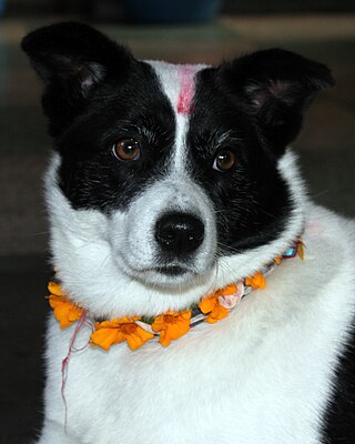
Kukur Tihar is an annual Hindu festival originating from Nepal which falls on the second day of the festival of Tihar. The second day of Tihar, called Kukur Tihar, is dedicated to the worship of dogs. On this day, people worship dogs to please Yama, the god of death, as they are considered to be his messengers. Dogs are decorated with tilaka and wear flower garlands around their necks. Worshippers offer them various foods including meat, milk, eggs, and dog food. It is considered a sin if someone acts disrespectfully to a dog on this day.

