Calama is a city and commune in the Atacama Desert in northern Chile. It is the capital of El Loa Province, part of the Antofagasta Region. Calama is one of the driest cities in the world with average annual precipitation of just 5 mm (0.20 in). The River Loa, Chile's longest, flows through the city. Calama has a population of 147,886.

Nevado Ojos del Salado is a dormant complex volcano in the Andes on the Argentina–Chile border. It is the highest volcano on Earth and the highest peak in Chile. The upper reaches of Ojos del Salado consist of several overlapping lava domes, lava flows and volcanic craters, with an only sparse ice cover. The complex extends over an area of 70–160 square kilometres (27–62 sq mi) and its highest summit reaches an altitude of 6,893 metres (22,615 ft) above sea level. Numerous other volcanoes rise around Ojos del Salado.
Cerro Paranal is a mountain in the Atacama Desert of northern Chile and is the home of the Paranal Observatory. Prior to the construction of the observatory, the summit was a horizontal control point with an elevation of 2,664 m (8,740 ft); now it is 2,635 m (8,645 ft) above sea level. It is the site of the Very Large Telescope and the VLT Survey Telescope. It is located 120 km (75 mi) south of Antofagasta and 80 km (50 mi) north of Taltal, as well as 15 km (9.3 mi) inland and 5 km (3.1 mi) west of highway B-710.

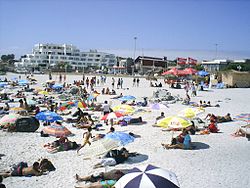
Caldera is a port city and commune in the Copiapó Province of the Atacama Region in northern Chile. It has a harbor protected by breakwaters, being the port city for the productive mining district centering on Copiapó to which it is connected by the first railroad constructed in Chile.

The Atacama Desert is a desert plateau located on the Pacific coast of South America, in the north of Chile. Stretching over a 1,600 km (990 mi) strip of land west of the Andes Mountains, it covers an area of 105,000 km2 (41,000 sq mi), which increases to 128,000 km2 (49,000 sq mi) if the barren lower slopes of the Andes are included.
The Chasicoan age is a period of geologic time from 10–9 Ma within the Late Miocene epoch of the Neogene, used more specifically within the SALMA classification in South America. It follows the Mayoan and precedes the Huayquerian age.

The Paso de Jama is a mountain pass through the Andes between Chile and Argentina, at an elevation of 4,200 m (13,800 ft) at the border. It is the northernmost road border crossing between the two countries. The pass is reached via Chile Route 27 and via National Route 52 (Argentina). The Chile Route 27 reaches an altitude according to OpenStreetMap of 4,831 metres (15,850 ft) at 23°04′21″S67°30′17″W in a road distance of 57.6 kilometres (35.8 mi) west of the border, making it one of the highest highways in South America.
Hiking in Chile is characterized by a wide range of environments and climates for hikers, which largely results from Chile's unusual, ribbon-like shape, which is 4,300 kilometres long and on average 175 kilometres wide. These range from the world's driest desert, the Atacama, in the north, through a Mediterranean climate in the center, to the glaciers, fjords and lakes of Patagonia in the south.

Salín is a mountain at the border of Argentina and Chile with an elevation of 6,029 metres (19,780 ft) metres. Salin is within the following mountain ranges: Argentine Andes, Chilean Andes, Puna de Atacama. Its territory is within the Argentinean protection area of Provincial Fauna Reserve Los Andes. It is on the border of 3 provinces: Argentinean province of Salta; Chilean provinces of El Loa and Antofagasta. Its slopes are within 3 cities: Argentinean city of Tolar Grande, Chilean cities of San Pedro de Atacama and Antofagasta (Chile).

El Ermitaño is a peak in Chile with an elevation of 6,146 metres (20,164 ft) metres located at Puna de Atacama. It is on the border of the Chilean provinces of Chañaral and Copiapó Along with Cerro Peña Blanca, lies on the southern rim of the Wheelwright Caldera.

Barrancas Blancas is a peak in Chile with an elevation of 6,119 metres (20,075 ft) metres. Barrancas Blancas is within the following mountain ranges: Chilean Andes and Puna de Atacama. It is located within the territory of the Chilean province of Copiapo. Its slopes are within the administrative boundaries of the Chilean commune of Copiapo.

Piscophoca is an extinct genus of pinniped. The genus was named after the fossiliferous Pisco Formation in Peru, where the holotype was found. Other fossils of the genus were found in the Bahía Inglesa Formation of the Caldera Basin in Chile.
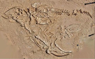
Cerro Ballena is a fossiliferous locality of the Bahía Inglesa Formation, located in the Atacama Desert along the Pan-American Highway a few kilometers north of the port of Caldera, Chile. It has been dated back to the Late Miocene epoch, during the Neogene period. The locality was first noted in 1965 during military work and fully excavated and studied between 2011 and 2012, and is protected by law since the latter year.

Sairecabur is a volcano located on the frontier between Bolivia and Chile. It is part of the Andean Central Volcanic Zone. Sairecabur proper is 5,971 m (19,590 ft) high; other mountains in the range are 5,722 m (18,773 ft) high Curiquinca, 5,819 m (19,091 ft) high Escalante and 5,748 m (18,858 ft) high Cerro Colorado, all of which have erupted a number of lava flows. Also in close proximity to Sairecabur lie the volcanic centres Licancabur, Putana and Juriques.
Caldera Basin is a sedimentary basin located in the coast of northern Chile west of Copiapó. The basin has a fill of marine sediments of Late Cenozoic age. With a north-south extension of 43 kilometres (27 mi) and an east-west width of 20 kilometres (12 mi) the basin occupies an area between the coast and the Chilean Coast Range and between the port of Caldera and the mouth of Copiapó River. The sedimentary fill rests on metamorphic rocks of Paleozoic age and on plutonic rocks of Mesozoic age.

The Bahía Inglesa Formation is a littoral, sedimentary, and highly fossiliferous geological formation that outcrops across the nearby coastal zones of Caldera, Chile. The unit is part of the greater Caldera Basin and was deposited in deep-shallow water, littoral paleoenvironments. It holds an exquisite fossil record in several localities, mostly composed of marine mammals, as well as invertebrate taxa.

Macraucheniinae is an extinct subfamily of macraucheniids that lived from the Late Miocene and potentially the Early Holocene, consisting of all the derived genera.

Micrauchenia is an extinct genus of macraucheniine litoptern that lived during the Late Miocene of what is now Chile. Fossils of this genus have been found in the Bahía Inglesa Formation in Chile.