
The Baja California Peninsula is a peninsula in Northwestern Mexico. It separates the Pacific Ocean from the Gulf of California. The peninsula extends 1,247 km from Mexicali, Baja California in the north to Cabo San Lucas, Baja California Sur in the south. It ranges from 40 km at its narrowest to 320 km at its widest point and has approximately 3,000 km of coastline and approximately 65 islands. The total area of the Baja California Peninsula is 143,390 km2 (55,360 sq mi).

Bahía de los Ángeles is a coastal bay on the Gulf of California, located along the eastern shore of the Baja California Peninsula in the state of Baja California, Mexico. The town of the same name is located at the east end of Federal Highway 12 about 42 miles (68 km) from the Parador Punta Prieta junction on Federal Highway 1. The area is part of the Ensenada Municipality.

Cabo San Lucas, or simply Cabo, is a resort city at the southern tip of the Baja California Peninsula, in the Mexican state of Baja California Sur. As of 2015, the population of the city was 81,111 inhabitants. Cabo San Lucas together with San José del Cabo is known as Los Cabos. Together they form a metropolitan area of 305,983 inhabitants.

The Peninsular Ranges are a group of mountain ranges that stretch 1,500 km (930 mi) from Southern California to the southern tip of the Baja California Peninsula; they are part of the North American Coast Ranges, which run along the Pacific Coast from Alaska to Mexico. Elevations range from 500 to 10,834 feet.
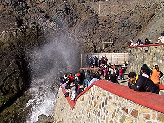
La Bufadora is a marine geyser or blowhole located on the Punta Banda Peninsula in Baja California, Mexico. The spout of sea water is the result of air, trapped in a sea cave, exploding upwards. Air is forced into the cave by wave action and is released when the water recedes. This interaction not only creates the spout, but a thunderous noise as well. The phenomena repeats every minute or so with its volume depending on the strength of the waves.

Mulegé is an oasis town in the Mexican state of Baja California Sur, situated at the mouth of the Río de Santa Rosalía. It is the fourth-largest community in Mulegé Municipality. It had a population of 3,821 according to the Mexican federal census of 2010.

Cedros Island is an island in the Pacific Ocean belonging to the state of Baja California, Mexico. The dry and rocky island had a population of 1,350 in 2005 and has an area of 348 square kilometres (134 sq mi) which includes the area of several small nearby islands. Cedros Island is mountainous, reaching a maximum elevation of 1,205 metres (3,953 ft). The economy is based on commercial fishing and salt mining. Cedros has a distinctive flora and the traces of some of the earliest human beings in the New World. The ocean around the island is popular with sports fishermen.

The municipality of Ensenada, with a land area of 52,482.40 km2 (20,263.57 sq mi), takes up the majority of the state of Baja California. It is the largest municipality in Mexico and in the Americas by area. It contains all of Baja California apart from a strip at the north and, at the northeast extremity of the state, the municipality of Mexicali. It is bordered by the Pacific Ocean on the west, the Gulf of California on the east, and by all of the other municipalities in Baja California on the North. Its municipal seat is Ensenada, which lies near the northwest corner of the municipality, although almost all of the municipality's territory lies far to its southeast. Its current municipal president is Enrique Pelayo Torres. A major port is planned to be built in Punta Colonet, a largely uninhabited area 80 km (50 mi) south of the city of Ensenada. Located offshore, Guadalupe Island is part of the municipality, making Ensenada the westernmost municipality of Latin America.

Federal Highway 1 is a free (libre) part of the federal highway corridors of Mexico, and the highway follows the length of the Baja California Peninsula from Tijuana, Baja California, in the north to Cabo San Lucas, Baja California Sur, in the south. The road connects with Via Rapida, which merges into the American Interstate 5 (I-5) at the international border south of San Ysidro, California.

Punta Prieta is a desert town in the Mexican state of Baja California, on Federal Highway 1.

Crotalus mitchellii is a venomous pit viper species found in the Southwestern United States and northern Mexico. It was named in honor of Silas Weir Mitchell (1829–1914), a medical doctor who also studied rattlesnake venoms. Five subspecies are currently recognized, including the nominate subspecies described here.

The Sierra de la Giganta is a mountain range of eastern Baja California Sur state, located on the southern Baja California Peninsula in northwestern Mexico.

Punta Sur marks the southern point of Cozumel and is part of the Parque Punta Sur, a 247-acre (1.00 km2) ecological park that covers the reefs, beaches, lagoons, and low forest of the surrounding area. The reef system is also part of the Arrecifes de Cozumel National Park.
Santa Anita is a village in Los Cabos Municipality, Baja California Sur, western Mexico. It is located north of San Jose del Cabo on the right bank of the Arroyo San José along Federal Highway 1. It had a population of 687 inhabitants in the 2010 census, and is situated at an elevation of 76 meters (249 ft.) above sea level.
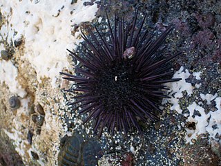
The sea urchins of the Gulf of California live between the coasts of the Baja California Peninsula to the west and mainland state of Sonora, Mexico to the east. The northern boundary is the lateral band of land with the remains of the Colorado River Delta, and the southern is the Pacific Ocean.
Punta Abreojos is a fishing town in Mulegé Municipality, Baja California Sur, Mexico.
Miraflores is a small town in the Municipality of Los Cabos. Miraflores is located about 45 miles north of San Jose del Cabo, 2 km west of Highway 1, just to the east of the Sierra de la Laguna. Miraflores is 220 meters above sea level. As of 2010, the town had a population of 1,384.
Harumi Fujita is a Japanese researcher of Mexican archaeology, who has specialized in pre-classical period of the northern states of Baja California and Baja California Sur. Her research has shown that fishing cultures had arisen in the area at the end of the Pleistocene period, indicating an occupation from at least 11,000 years ago. In a cave shelf known as the Babisuri Shelter, radiocarbon dating indicated the area may have been occupied 40,000 years ago.


