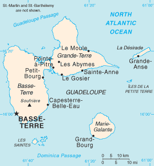
Basse-Terre is a commune in the French overseas department of Guadeloupe, in the Lesser Antilles. It is also the prefecture of Guadeloupe. The city of Basse-Terre is located on Basse-Terre Island, the western half of Guadeloupe.

Baillif is a commune of Guadeloupe, an overseas region and department of France located in the Lesser Antilles. Baillif is a suburb of Basse-Terre, the prefecture and second-largest urban area of Guadeloupe located on Basse-Terre Island.

Pointe-à-Pitre International Airport or Pointe-à-Pitre Le Raizet Airport is an international airport serving Pointe-à-Pitre on the island of Grande-Terre in Guadeloupe, France.

The arrondissement of Basse-Terre is an arrondissement of France in the Guadeloupe department in the Guadeloupe region. It has 18 communes. Its population is 189,210 (2016), and its area is 854.3 km2 (329.8 sq mi).

Vieux-Habitants is a commune on Guadeloupe, a French overseas department in the Caribbean. It is located on the southwest coast of the island of Basse-Terre.
The Canton of Vieux-Habitants is a canton in the Arrondissement of Basse-Terre on the island of Guadeloupe.

Guadeloupe National Park is a national park in Guadeloupe, an overseas department of France located in the Leeward Islands of the eastern Caribbean region. The Grand Cul-de-Sac Marin Nature Reserve is a marine protected area adjacent to the park and administered in conjunction with it. Together, these protected areas comprise the Guadeloupe Archipelago biosphere reserve.

Air Guadeloupe was a small French international airline with its head office in Les Abymes, Guadeloupe, France. At one time, it was on the property of Le Raizet Airport. Later it was located in the Immeuble Le Caducet.

Articles related to the French overseas department of Guadeloupe include:
Marie-Galante Airport is an airport serving the island of Marie-Galante in Guadeloupe. It is located 5.5 km (3.0 NM) east of Grand-Bourg, one of three communes on the island.

Les Saintes Airport is an airport serving the archipelago of Îles des Saintes, French West Indies. It is on an isthmus in the middle of Terre-de-Haut Island, a dependency of Guadeloupe.

The Invasion of Guadeloupe was the last conflict between French and British forces during the Napoleonic Wars, and took place after Napoleon's defeat at Waterloo.
La Désirade Airport is an airport serving La Désirade, the easternmost island of Guadeloupe.
Saint-François Airport is an airport serving Saint-François, a town at the southeastern tip of Grande Terre island in Guadeloupe.
Charles Auger de La Motte was a French colonial administrator. He was governor in turn of Marie-Galante, Guadeloupe and Saint-Domingue.
Communauté d'agglomération Grand Sud Caraïbe is a communauté d'agglomération, an intercommunal structure in the Guadeloupe overseas department and region of France. Created in 2011, its seat is in Basse-Terre. Its area is 343.5 km2. Its population was 77,186 in 2019.


