Christchurch is a town and civil parish in Dorset on the south coast of England. The town covers an area of 19.5 square miles (51 km2) and had a population of 48,368 in 2013. It adjoins Bournemouth to the west, with the New Forest to the east. Part of the historic county of Hampshire, Christchurch was a borough within the administrative county of Dorset from 1974 until 2019, when it became part of the new Bournemouth, Christchurch and Poole unitary authority.

Poole is a large coastal town and seaport in Dorset, on the south coast of England. The town is 21 miles (34 km) east of Dorchester and adjoins Bournemouth to the east. Since 1 April 2019, the local authority is Bournemouth, Christchurch and Poole Council which is a unitary authority. Poole had an estimated population of 151,500 making it the second-largest town in the ceremonial county of Dorset. Together with Bournemouth and Christchurch, the conurbation has a total population of nearly 400,000.

Sandbanks is a small peninsula or spit crossing the mouth of Poole Harbour on the English Channel coast at Poole in Dorset, England. It is known for its high property prices and for its award-winning beach. In 2005, Sandbanks was reported to have the fourth highest land value by area in the world. The Sandbanks and Canford Cliffs Coastline area has been dubbed "Britain's Palm Beach".

Hamworthy is a village, parish, peninsula and suburb of Poole in Dorset, England. It is sited on a peninsula of approximately 3 square kilometres (1.2 sq mi) that is bordered by the town of Upton to the north, Poole Harbour to the south, Lytchett Bay to the west and Holes Bay to the east. Poole Bridge, the southern terminus of the A350 road, connects the suburb with the town centre. Hamworthy is the location of the Port of Poole ferry passenger terminal and cargo handling operations.

Eastleigh railway station serves the town of Eastleigh in the county of Hampshire in England. It is located on the South West Main Line and is the junction station for two other routes, the Eastleigh-Fareham Line and the Eastleigh-Romsey Line. It is 73 miles 35 chains (118.2 km) from London Waterloo. South of the station are Eastleigh Railway Works and Eastleigh Depot.

Dorset County Council (DCC) was the county council for the county of Dorset in England. It provided the upper tier of local government, below which were district councils, and town and parish councils. The county council had 46 elected councillors and was based at County Hall in Dorchester. The council was abolished on 31 March 2019 as part of structural changes to local government in Dorset.

Bournemouth Borough Council was the local authority of Bournemouth in Dorset, England and ceased to exist on 1 April 2019. It was a unitary authority, although between 1974 and 1997 it was an administrative district council with Dorset. Previously most of the borough was part of Hampshire.

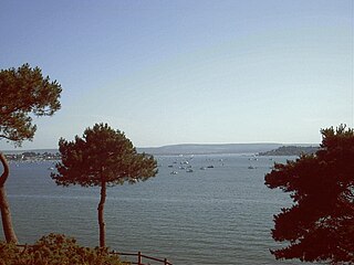
Lilliput is a district of Poole, Dorset. It borders on Sandbanks, Canford Cliffs, Lower Parkstone, and Whitecliff and has a shoreline within Poole Harbour with views of Brownsea Island and the Purbeck Hills. Brownsea Island stands opposite Lilliput's harbour foreshore and is famous as the birthplace of Baden Powell's International Scouting Movement. Lilliput itself was host to a number of early scouting camps. During the Second World War at one stage it provided Britain's only civilian air route: Poole Harbour was temporary home to the Imperial Airways/BOAC flying boat fleet, which had its passenger HQ at Salterns Marina.

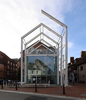
Poole Museum is a local history museum situated on the Lower High Street in the Old Town area of Poole, Dorset, and is part of the Borough of Poole Museum Service. Entrance to Poole Museum is free, and the museum is the fifth most visited free attraction in South West England.

Whitecliff, is a small area of Parkstone in Poole, Dorset, England. It is situated near the eastern shore of Poole Harbour and is a very sought-after residential district of Poole due to its park and harbour view.

East Cliff is a suburb and ward in Bournemouth, Dorset, England.

Townsend is a area of Bournemouth, Dorset. It is located in the suburbs along the north eastern boundary of the town and is close to the Royal Bournemouth Hospital.

Strouden Park is an area of Bournemouth, Dorset, England.

The Port of Poole is a cross channel port on Poole Harbour in Poole, Dorset, South West England. Along with Weymouth Harbour, Poole has the other major Channel Port in Dorset.

Friars Cliff is a neighborhood and beach in Christchurch, Dorset. It is east of Mudeford and west of Highcliffe.
Harbourside Park in Poole, England has two components:
The economy of the County of Dorset in South West England was worth £16.189 billion to the UK economy in 2013.

Poole Town is an electoral ward in Poole, Dorset. Since 2019, the ward has elected 2 councillors to Bournemouth, Christchurch and Poole Council.


