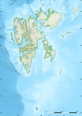
Svalbard, previously known as Spitsbergen or Spitzbergen, is a Norwegian archipelago in the Arctic Ocean. North of mainland Europe, it lies about midway between the northern coast of Norway and the North Pole. The islands of the group range from 74° to 81° north latitude, and from 10° to 35° east longitude. The largest island is Spitsbergen, followed in size by Nordaustlandet and Edgeøya. The largest settlement is Longyearbyen on the west coast of Spitsbergen.
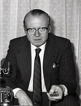
Kjell Torbjørn Holler was a Norwegian economist and politician with the Norwegian Labour Party and a Minister of Industry.

Stallobreen is a glacier in Oscar II Land at Spitsbergen, Svalbard. It has a length of about 4.5 kilometers, and is located between the mountains of Stallofjellet, Sparrefjellet and Heksefjellet, near the glacier complex of Eidembreen.
Løvliebreen is a glacier in Oscar II Land at Spitsbergen, Svalbard. It has a length of about five kilometers, and is located between the mountain ranges of Gunnar Knudsenfjella and Holmesletfjella. The glacier debouches northwards towards St. Jonsfjorden. It is named after Norwegian businessperson Andreas Løvlie along with the nearby mountain of Løvliefjellet.

Tinayrebreen is a glacier in Haakon VII Land at Spitsbergen, Svalbard. It has a length of about ten kilometers, and extends from the glacier cap of Isachsenfonna to Möllerfjorden, where it debouches into the bay of Tinayrebukta. The glacier is named after French painter Louis Tinayre.

Hayesbreen is a glacier in Sabine Land at Spitsbergen, Svalbard. It is named after American politician and Arctic explorer Isaac Israel Hayes. The glacier has a length of about eighteen kilometers, and debouches into the bay of Mohnbukta. Surrounding mountains are Aagaardfjellet to the north, Jebensfjellet to the south, and Panofskyfjellet where Hayesbreen joins the glacier of Königsbergbreen.
Luitpoldbreen is a glacier in Sabine Land at Spitsbergen, Svalbard. It is named after Luitpold, Prince Regent of Bavaria. The glacier is a tributary to Hayesbreen. The mountain of Jebensfjellet is surrounded by Luitpoldbreen, Hayesbreen and Königsbergbreen.
Linnébreen is a glacier in Nordenskiöld Land at Spitsbergen, Svalbard, Norway. It is named after Swedish botanist Carl Linnaeus. The glacier has a length of about 3.5 kilometers, and flows from the mountain of Systemafjellet towards the valley of Linnédalen. It is proximate to the mountain of Christensenfjella.
Mathiesenfjella is a mountain group in Oscar II Land at Spitsbergen, Svalbard. The group is named after Norwegian businessman Haaken L. Mathiesen.
Svalisbreen is a glacier in Sørkapp Land at Spitsbergen, Svalbard. It has a length of about 12.5 kilometers, extending from the mountain pass of Svanhildpasset to Hornbreen, towards the bay of Brepollen, the inner part of Hornsund.

Storbreen is a glacier in Torell Land at Spitsbergen, Svalbard. It has a length of about fifteen kilometers, and debouches towards the bay of Brepollen, the inner part of Hornsund.
Skilfonna is a glacier in Sørkapp Land at Spitsbergen, Svalbard. It is located west of Russefjella, and separates the glacier of Hedgehogfonna from Vasil'evbreen. The mountains of Brendetoppane separate Skilfonna from Svalisbreen.
Hedgehogfonna is a glacier field in Sørkapp Land at Spitsbergen, Svalbard. It is located west of the mountain of Hedgehogfjellet, and is separated from the glacier of Vasil'evbreen by Skilfonna.
Tromsøbreen is a glacier in Sørkapp Land at Spitsbergen, Svalbard. It has a length of about six kilometers, and extends southwards from the ice field of Hedgehogfonna towards the sea. The glacier is named after the Norwegian city of Tromsø.
Hedgehogfjellet is a mountain in Sørkapp Land at Spitsbergen, Svalbard. It has a height of 615 m.a.s.l. The mountain is situated south of Tvillingtoppen, between the sea and the glacier of Hedgehogfonna.

Scheelebreen is a glacier in Nathorst Land at Spitsbergen, Svalbard. It has a length of about sixteen kilometers, and is located between the mountains of Vriompeisen and Fagerstafjella. The glacier is named after Swedish chemist Carl Wilhelm Scheele.
Vriompeisen is a mountain area in Nathorst Land at Spitsbergen, Svalbard. It comprises the peaks of Kroknosa, Peisen and Peisnosa, which form a U-shape surrounding the glacier of Peisbreen. Vriompeisen is located between the glaciers of Paulabreen, Scheelebreen, Klubbebreen and Sokkbreen.
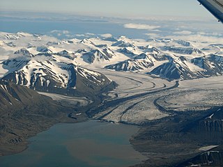
Paulabreen is a glacier in Nathorst Land and Heer Land at Spitsbergen, Svalbard. It has a length of about fifteen kilometers, extending from the mountain of Kjølberget to the bay of Rindersbukta. The glacier is named after Paula, the wife of shipmaster Richard Ritter von Barry. Paulabreen borders to the mountain area of Vriompeisen, and the mountain of Hollertoppen. A tributary glacier is Bakaninbreen.
Hollertoppen is a mountain in Heer Land at Spitsbergen, in the Norwegian archipelago of Svalbard in the Arctic Ocean.
Rindersbukta is a bay in Nathorst Land and Heer Land at Spitsbergen, Svalbard. It forms the southern branch of Van Mijenfjorden. The glaciers of Scheelebreen and Paulabreen debouche into the bay. The bay is named after Dutch whaler Michiel Rinders.